ArcGIS API for JavaScript 4.2学习笔记[28] 可视域分析【使用Geoprocessor类】
想知道可视域分析是什么,就得知道可视域是什么
我们站在某个地方,原地不动转一圈能看到的所有事物就叫可视域。当然平地就没什么所谓的可视域。
如果在山区呢?可视范围就会被山体挡住了。这个分析对军事上有十分重要的意义。
在本例中,可视域是以GraphicLayer中的Graphics[]形式存在的。
这个例子用到了Geoprocessor这个类。这个类的对象是如何判别我要进行可视域分析呢?且听我慢慢道来。
看看结果

点击山谷的位置,出现一个红点,稍等10s左右,出现橙色的面块,橙色的面块就是红点位置所能看到的范围了(比起桌面的可视域分析还是弱了点),比起桌面来说可谓是所见即所得。
这个在AJS 3.x是做不到的,因为这里有强大的3D分析功能嘛。
Geoprocessor类
这个类很强大,和之前的四个Task不太一样,它接受的处理参数不再是一个类,而是一个Object数组。也就是说,是什么样子的处理,就输入什么样的参数。
官方举例如下:
假设有Input_Points和Distance两个需要输入的参数,那么

就在Geoprocessor类的execute()方法中传入这么一个Object对象:
{
   Input_Points: <FeatureSet>,
   Distance: <Number>
}
这就是GP类的强大之处。如果需要进行异步操作,则使用submitJob()代替execute()方法,节约网页等待时间。
Geoprocessor类的execute()方法返回一个Object对象,其包含有:
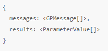
两个属性,我们关心的是results属性,其为ParameterValue[]类型。下面我就要说说ParameterValue这个类,它和前面某某Result类十分相似。
ParameterValue类
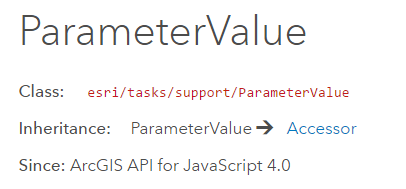
它是execute()或submitJob()的返回值中的results属性类型。
它有三个属性:dataType(String类型)、declareClass和value(Object类型)
什么意思呢?GP处理的结果当然是因输入的参数决定的,所以在本例中,dataType就规定成了"record-set"或"feature-record-set-layer", 即value属性就被装箱成了FeatureSet类型。
dataType的值就确定了value的值类型,见这个表格:点我
有了这些预备知识,讲解这个例子和下一个例子就不难了。
给出引用
require([
    "esri/Map",
    "esri/views/SceneView",
    "esri/layers/GraphicsLayer","esri/Graphic",
    "esri/geometry/Point",
    "esri/symbols/SimpleMarkerSymbol","esri/symbols/SimpleFillSymbol",
    "esri/tasks/Geoprocessor",
    "esri/tasks/support/LinearUnit","esri/tasks/support/FeatureSet",
    "dojo/domReady!"
  ],
  function(Map, SceneView, GraphicsLayer, Graphic, Point,
    SimpleMarkerSymbol, SimpleFillSymbol, Geoprocessor,
    LinearUnit, FeatureSet) {
    ...
    }
);
嗯,对Geoprocessor的引用。
函数框架
function(...){
    var gpUrl ="https://sampleserver6.arcgisonline.com/arcgis/rest/services/Elevation/ESRI_Elevation_World/GPServer/Viewshed";
    var map = new Map({...});
    var view = new SceneView({...});
    var graphicsLayer = new GraphicsLayer({...)};
    map.add(graphicsLayer);

    var markerSymbol = new SimpleMarkerSymbol({...});
    var fillSymbol = new SimpleFillSymbol({...});

    var gp = new Geoprocessor(gpUrl);
    gp.outSpatialReference = {...};

    //重点
    view.on("click", computeViewshed);

    function computeViewshed(event){...}
    function drawResultData(result){...}
}
我想到这,就不必解释很多了,我们直接关注数据处理的重点代码:view的click事件和两个处理函数computeViewshed()和drawResultData()。
gp这个Geoprocessor类的实例化在上方已经说明了,就不说那么详细了。
computeViewshed(event)方法
这个方法有点长,但是每一行的意义都很明确。它做的就是获取点击点,生成一个红色的点符号,然后获取gp.execute()的输入参数,执行execute()方法。


function computeViewshed(event) {
  graphicsLayer.removeAll();

  var point = new Point({
    longitude: event.mapPoint.longitude,
    latitude: event.mapPoint.latitude
  });

  var inputGraphic = new Graphic({
    geometry: point,
    symbol: markerSymbol
  });

  graphicsLayer.add(inputGraphic);

  var inputGraphicContainer = [];
  inputGraphicContainer.push(inputGraphic);
  var featureSet = new FeatureSet();
  featureSet.features = inputGraphicContainer;

  var vsDistance = new LinearUnit();
  vsDistance.distance = 5;
  vsDistance.units = "miles";

  var params = {
    "Input_Observation_Point": featureSet,
    "Viewshed_Distance": vsDistance
  };

  gp.execute(params).then(drawResultData);
}
首先,图形图层清零,获取点击点,命名为point(Point类的实例);
然后,根据这个point形成一个Graphic对象,名为inputGraphic,添加到图形图层中(显示点击点);
之后,根据可视域分析服务所需的参数
drawResultData()方法
function drawResultData(result) {
  var resultFeatures = result.results[0].value.features;

  var viewshedGraphics = resultFeatures.map(function(feature) {
    feature.symbol = fillSymbol;
    return feature;
  });

  graphicsLayer.addMany(viewshedGraphics);

  view.goTo({
    target: viewshedGraphics,
    tilt: 0
  });
}
result即为execute()返回的Object对象,获取results[0]的value(即FeatureSet)中的features(类型为Graphic[]),命名为resultFeatures。
对这个Graphic[]变量进行遍历(map()方法),对每个Graphic设置填充符号,返回一个新的Graphic[]变量viewshedGraphics;
然后把这个Graphic[]变量添加到图形图层上;
最后让视图跳转到这个图形图层。
总结一下
通过单击,获取这个点位信息——通过这个点生成需要的可视域分析所需的参数集(Object类型),传入gp.execute()——对返回的Object对象中的可视域进行处理、显示。
完美!

 浙公网安备 33010602011771号