
基于uni-app+vue3实现的微信小工具地图范围限制与单点标记功能实现指南
一、功能概述
本文将分步骤讲解如何使用uni-app框架在微信小程序中实现以下功能:
显示基础地图
绘制特定区域范围(以郑州市为例)
实现点击地图添加标记点
限制标记点只能在指定区域内添加
显示选中位置的坐标信息
二、分步骤实现
步骤1:搭建基础地图
1.1 添加map组件
在页面template中添加map组件:
1.2 设置地图中心点
在script部分设置地图初始中心点(xxx位置):
import { ref } from 'vue'
const center = ref({
latitude: 34.747,   // 纬度
longitude: 113.625  // 经度
})
步骤2:绘制郑州市范围
2.1 定义郑州市边界坐标
const zhengzhouPolygon = [
{latitude: 34.936, longitude: 112.842}, // 西北角
{latitude: 34.936, longitude: 114.023}, // 东北角
{latitude: 34.524, longitude: 114.023}, // 东南角
{latitude: 34.524, longitude: 112.842}, // 西南角
{latitude: 34.936, longitude: 112.842}  // 闭合多边形
]
2.2 添加polygons属性到map组件 绘制限制范围
const polygons = ref([{
points: zhengzhouPolygon,
strokeWidth: 2,
strokeColor: "#1E90FF",
fillColor: "#1E90FF22"
}])
更新map组件:
步骤3:实现点击添加标记功能
3.1 初始化markers和选中点
const markers = ref([])
const selectedPoint = ref(null)
const isInZhengzhou = ref(false)
3.2 实现点击事件处理
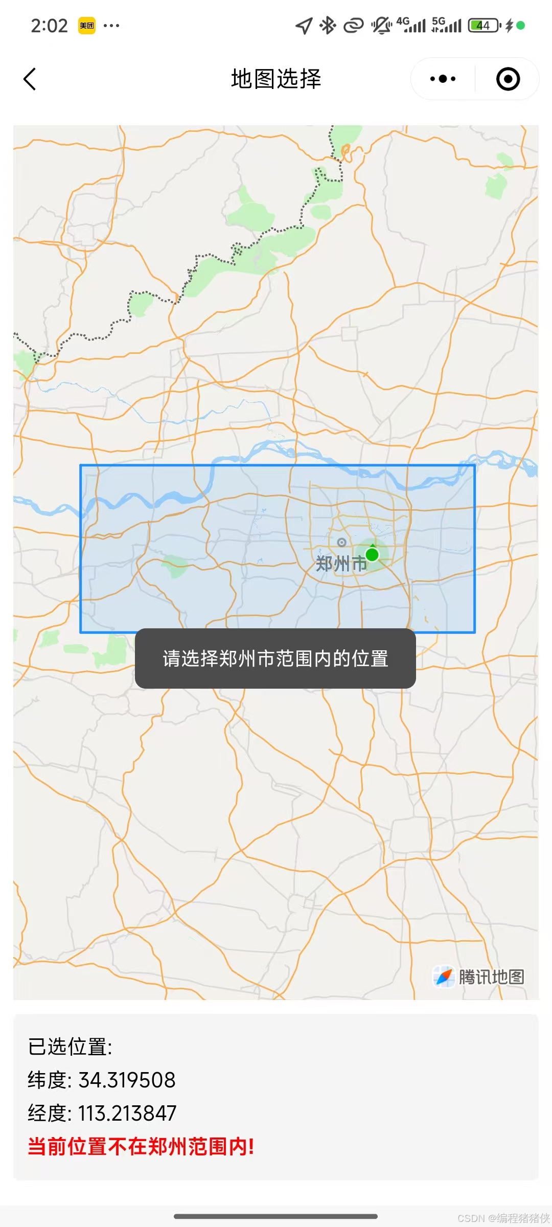
const handleMapTap = (e) => {
const { latitude, longitude } = e.detail
selectedPoint.value = { latitude, longitude }
// 判断是否在郑州范围内
isInZhengzhou.value = isPointInPolygon(
{latitude, longitude},
zhengzhouPolygon
)
if (isInZhengzhou.value) {
// 在范围内,添加标记
markers.value = [{
id: 1,
latitude,
longitude,
iconPath: '/static/location.png', // 替换为你的标记图标路径
width: 30,
height: 30,
title: "选择的位置"
}]
} else {
// 不在范围内,清除标记并提示
markers.value = []
uni.showToast({
title: "请选择郑州市范围内的位置",
icon: "none",
duration: 2000
})
}
}
步骤4:实现点在多边形内判断(射线法)
function isPointInPolygon(point, polygon) {
const x = point.longitude, y = point.latitude
let inside = false
for (let i = 0, j = polygon.length - 1; i  y) !== (yj > y)) &&
(x < (xj - xi) * (y - yi) / (yj - yi) + xi)
if (intersect) inside = !inside
}
return inside
}
步骤5:添加信息显示区域
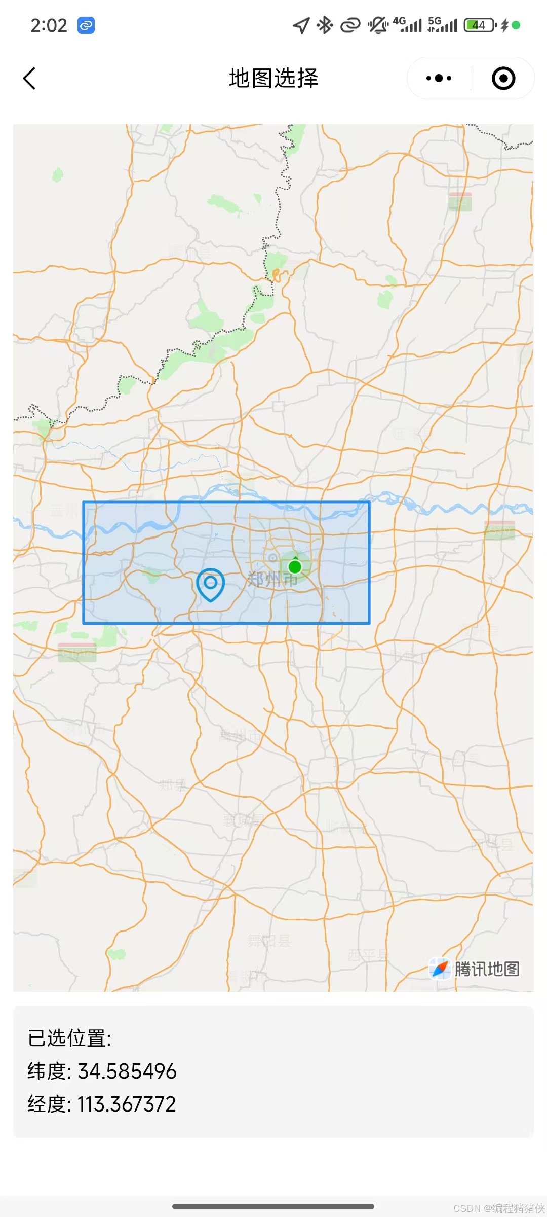
已选位置:
纬度: {{selectedPoint.latitude.toFixed(6)}}
经度: {{selectedPoint.longitude.toFixed(6)}}
当前位置不在郑州范围内!
添加样式:
.container {
padding: 20rpx;
}
.info-box {
margin-top: 20rpx;
padding: 20rpx;
background-color: #f5f5f5;
border-radius: 10rpx;
}
.info-box text {
display: block;
margin: 10rpx 0;
font-size: 28rpx;
}
.error {
color: #ff0000;
font-weight: bold;
}
三、完整代码
已选位置:
纬度: {{selectedPoint.latitude.toFixed(6)}}
经度: {{selectedPoint.longitude.toFixed(6)}}
当前位置不在郑州范围内!
import { ref } from 'vue'
// 郑州市边界坐标
const zhengzhouPolygon = [
{latitude: 34.936, longitude: 112.842},
{latitude: 34.936, longitude: 114.023},
{latitude: 34.524, longitude: 114.023},
{latitude: 34.524, longitude: 112.842},
{latitude: 34.936, longitude: 112.842}
]
// 地图中心点(郑州二七塔)
const center = ref({
latitude: 34.747,
longitude: 113.625
})
// 多边形配置
const polygons = ref([{
points: zhengzhouPolygon,
strokeWidth: 2,
strokeColor: "#1E90FF",
fillColor: "#1E90FF22"
}])
// 标记点
const markers = ref([])
const selectedPoint = ref(null)
const isInZhengzhou = ref(false)
// 判断点是否在多边形内
function isPointInPolygon(point, polygon) {
const x = point.longitude, y = point.latitude
let inside = false
for (let i = 0, j = polygon.length - 1; i  y) !== (yj > y)) &&
(x  {
const { latitude, longitude } = e.detail
selectedPoint.value = { latitude, longitude }
isInZhengzhou.value = isPointInPolygon(
{latitude, longitude},
zhengzhouPolygon
)
if (isInZhengzhou.value) {
markers.value = [{
id: 1,
latitude,
longitude,
iconPath: '/static/location.png',
width: 30,
height: 30,
title: "选择的位置"
}]
} else {
markers.value = []
uni.showToast({
title: "请选择郑州市范围内的位置",
icon: "none",
duration: 2000
})
}
}
.container {
padding: 20rpx;
}
.info-box {
margin-top: 20rpx;
padding: 20rpx;
background-color: #f5f5f5;
border-radius: 10rpx;
}
.info-box text {
display: block;
margin: 10rpx 0;
font-size: 28rpx;
}
.error {
color: #ff0000;
font-weight: bold;
}
通过以上步骤,我们完整实现了一个限制区域范围的单点标记功能。开发者可以根据实际需求调整区域范围或扩展更多功能。。。ps:markers中的iconpath 如果不传 会展示系统默认的标记点,如果要根据经纬度获取地名则需要申请对接地图的接口才能实现
四、实现效果
![]()
![]()

 浙公网安备 33010602011771号