
Web Services Introduction:
(http://www.esri.com/news/arcnews/fall03articles/serving-our-world2of2.html)
Availability of the product to realize cartographic web-services http://www.geographynetwork.com/data/dynamicdata.html
1.0 、Introduction: The sharing of knowledge brings us to Web services, which provide us with a new infrastructure linking users and servers with portals that are server-centric. It's the foundation for GIS networks. It's now possible to dynamically bring together multiple distributed services so that they can be overlaid visually or analyzed together. For example, we can now merge real-time weather maps that change every 15 seconds with flight path maps that change every 14 days. This can create a whole new service for pilots, showing dynamically these two changing thematic geographic layers.

Web services are an integration infrastructure. They allow us to take distributed servers through a portal and build standard products. Another example is the U.S. Geological Survey (USGS) National Map, which is being created by overlaying data sets from distributed servers and viewing them together. Other custom products would facilitate data collection and spatial analysis.
Web services are also an enterprise architecture. For example, a department can connect with other departments through portals into a network of systems. We can begin to integrate large agencies or companies' distributed applications using Web services. Portals are a key for linking users to various distributed services.

These new technologies of Web services, GIS servers, and portals excite me because I can see the future coming. They're going to provide us with platforms for sharing our knowledge. Fundamental to my beliefs is that information makes a difference. GIS Web services will help us abstract information, share it, encapsulate geographic knowledge, and build intelligent geographic information systems.
Web services are only now coming of age—their full implementation will bring new opportunities to work more collaboratively, not just by data sharing and working on a common project, but really connecting our individual work models, work flows, methods, etc., into a global network of helping each other. I believe future generations will benefit from these efforts. By creating, managing, and connecting our individual components and contributions of work on the earth into a kind of global infrastructure, I believe GIS professionals will build this infrastructure and serve the world.
Web services will, therefore, play a role in geographic knowledge sharing, providing users with an infrastructure of servers with portals. ArcIMS is a major part of the technology for building these GIS networks. One example is the recent launch of the United States Office of Management and Budget's Geospatial One-Stop (geodata.gov), a portal referencing spatial data from many government agencies at the U.S. federal, state, and local levels. This portal is a gateway for building a spatial data infrastructure in the United States. It is the first step in beginning to organize the geographic knowledge components-not just the data but many types of services.

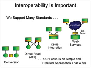
Interoperability
Interoperability is important to this new environment. ESRI has long supported open standards for data sharing and open services. An example: Fifteen years ago, we simplified the direct reading of data with the publishing of the shapefile and integrating data in various database management systems (DBMSs), but the Web services platform for interoperability is much stronger. The use of XML and Simple Object Access Protocol (SOAP) allows us to very quickly interchange between different types of services and integrate them. Our focus on standards will be a practical approach that really works.
1、Web Services
1.1、Web services are self-contained application components that provide specific functionality to other applications via the Internet.Applications can access Web services through Web protocols such as HTTP and XML, without concern for how each service is implemented. Application developers can combine Web services or use them with other tools to perform a larger function or provide a complete solution.the architecture is follow:

1.2、Web Services technology
WSDL (Web Service Description Language)
SOAP(Simple Object Access Protocol)
What is a REST Web Service
The acronym REST stands for Representational State Transfer, this basically means that each unique URL is a representation of some object. You can get the contents of that object using an HTTP GET, to delete it, you then might use a POST, PUT, or DELETE to modify the object (in practice most of the services use a POST for this).
Who's using REST?
All of Yahoo's web services use REST, including Flickr, del.icio.us API uses it, pubsub, bloglines, technorati, and both eBay, and Amazon have web services for both REST and SOAP.
Who's using SOAP?
Google seams to be consistent in implementing their web services to use SOAP, with the exception of Blogger, which uses XML-RPC. You will find SOAP web services in lots of enterprise software as well.
REST vs SOAP
As you may have noticed the companies I mentioned that are using REST api's haven't been around for very long, and their apis came out this year mostly. So REST is definitely the trendy way to create a web service, if creating web services could ever be trendy (lets face it you use soap to wash, and you rest when your tired). The main advantages of REST web services are:
- Lightweight - not a lot of extra xml markup
- Human Readable Results
- Easy to build - no toolkits required
SOAP also has some advantages:
- Easy to consume - sometimes
- Rigid - type checking, adheres to a contract
- Development tools
For consuming web services, its sometimes a toss up between which is easier. For instance Google's AdWords web service is really hard to consume (in CF anyways), it uses SOAP headers, and a number of other things that make it kind of difficult. On the converse, Amazon's REST web service can sometimes be tricky to parse because it can be highly nested, and the result schema can vary quite a bit based on what you search for.
Which ever architecture you choose make sure its easy for developers to access it, and well documented.
1.2、GIS Web Services
(http://www.esri.com/news/arcnews/fall03articles/serving-our-world2of2.html)
GIS Web services are Internet applications that use data and related functionality to perform basic geoprocessing tasks such as
- Address matching
- Spatial searches
- Routing
- Mapping
- Geocoding
According to the OGC framework (OGC 2002), GIS services are logically grouped into three categories:
(1) Data Services typically provide function of accessing and query of spatial data. Such services are tightly coupled with spatial data such as Web Feature Service (WFS), Web Coverage Service (WCS) of OGC.
(2) Processing Services are not associated with specific datasets. Instead they provide operations for processing or transforming data in a manner determined by user-specified parameters [1]. Such services include projection/coordinate conversion, map overlay, imagery manipulation, and imagery classification and so on.
(3) Registry/catalog services are used to classify, register, describe, search, maintain and access information about Web Services (OGC 2002).
Introduction ofWMS
A Web Map Service (WMS) produces maps of georeferenced data. We define a "map"
as a visual representation of geodata; a map is not the data itself. This specification
defines three WMS operations: GetCapabilities returns service-level metadata, which is
a description of the service's information content and acceptable request parameters;
GetMap returns a map image whose geospatial and dimensional parameters are welldefined;
GetFeatureInfo (optional) returns information about particular features shown
on a map.
Introduction of WCS
The Web Coverage Service (WCS) supports the networked interchange of geospatial data
as "coverages" containing values or properties of geographic locations. Unlike the Web
Map Service (WMS) (OGC document #01-021r2), which filters and portrays spatial data
to return static maps (server-rendered as pictures), the Web Coverage Service provides
access to intact (unrendered) geospatial information, as needed for client-side rendering,
multi-valued coverages, and input into scientific models and other clients beyond simple
viewers.
The Web Coverage Service consists of three operations: GetCapabilities, GetCoverage,
and DescribeCoverageType. The GetCapabilities operation returns an XML document
describing the service and the data collections from which clients may request coverages.
Clients would generally run the GetCapabilities operation and cache its result for use
throughout a session, or reuse it for multiple sessions.
Introduction of WFS
This document (OpenGIS Web Feature Service Implementation Specification) takes the next logical step and proposes interfaces for describing data manipulation operations on geographic features using HTTP as the distributed computing platform. Data manipulation operations include the ability to:
1. Create a new feature instance
2. Delete a feature instance
3. Update a feature instance
4. Get or Query features based on spatial and non-spatial constraints
A Web Feature Service (WFS) request consists of a description of query or data transformation operations that are to be applied to one or more features. The request is generated on the client and is posted to a web feature server using HTTP. The web feature server then reads and (in a sense) executes the request.
A Web Processing Service provides access to calculations or models which operate on spatially referenced data. The data required by the service can be available locally, or delivered across a network using data exchange standards such as GML or GDAS. The calculation can be as simple as subtracting one set of spatially referenced numbers from another (e.g. determining the difference in influenza cases between two different seasons), or as complicated as a global climate change model.
The WPS specification is intended to provide a mechanism to identify the spatially-referenced data required by the calculation, initiate the calculation, and manage the output from the calculation so that it can be accessed by the client.
1.3、Adventage of GIS Web services
GIS Web services enable application developers to integrate GIS functionality into their Web applications without having to build the functionality or host the mapping data locally. and access the most current data available without having to store any of that data on your system or maintain it over time
the GIS web services provides access to geographic data sets that can be accessed for use within your GIS software or mapping application. These services may be previewed online and then used, for free or for a subscription fee, within your GIS software (such as ArcGIS or ArcExplorer) or custom mapping application.they can provide users with dynamic maps and data allow direct interaction with content. Content is delivered in one of two ways
- Map images generated from data on the map server.
- Compressed vector features streamed to you and displayed in your GIS software.
when users Use Dynamic Data and Maps rather than traditional mechanisms such as CD-ROMs. The data sets used in dynamic maps and data are stored and maintained by the data publisher or its hosting service provider. When you make a request to a dynamic maps and data service, you can access the most current data available without having to store any of that data on your system or maintain it over time.
With dynamic data and maps, you can access data as either an image or feature service. You can use the service as a background layer for other local data or interact with the data as a traditional feature source. In either case, you can stream down only the data you need and discard it when you are done.
1.4、Availability of the product to realize cartographic web-services
• Most commercial GIS server products and search sites deliver maps and geospatial functionality using a proprietary architecture/API
• These products include the following:
– ArcIMS (ESRI)
– ArcGIS Server (ESRI)
– ArcWeb Services (ESRI)
– MapXtreme (MapInfo)
– MapGuide (Autodesk)
– Geomedia WebMap (Intergraph)
– MapPoint
– Google Maps (Google)
– Live Search Maps (Microsoft)
– Mapquest
– Yahoo Maps
• However, most of the above products can publish open services (e.g, WMS) that meet open standards
• Additionally there are many open source GIS products (e.g., MapServer) which are collaborative efforts and do not use proprietary architectures… these are typically based on open standards
1.5、Availability GIS Web Services and Services and functionality
Google Maps is a free web mapping service application and technology provided by Google that powers many map-based services including the Google Maps website, Google Ride Finder, Google Transit and embedded maps on third-party websites via the Google Maps API. It offers street maps, a route planner for traveling by foot, bicycle, car, or public transport and an urban business locator for numerous countries around the world. It also can help with finding businesses.The GIS (Geographic Information System) data used in Google Maps are provided by Tele Atlas. '
Google's use of Google Maps
Live Search Maps (previously Windows Live Maps and Windows Live Local) is a web mapping service provided as a part of Microsoft's Windows Live online applications services suite and powered by the Microsoft Virtual Earth framework.
Features:
Satellite Images
Bird's eye view
3D Maps
ClearFlow
Other features
• Terrain details are also available in 3D mode.
• Finding, viewing, and printing driving directions
• Traffic viewing (in several major cities)
• User points of interest that can be stored and shared
• Drawing on maps
• A location finder that can locate the user's location
• Integrated route calculation
• Street-level photos (from all directions) in Seattle, WA (city center) and San Francisco, CA (city center). Users can view these photos by driving a race or sports car, or by having a walk. Street-level photography is currently only available as part of a separate tech preview site
Compatibility:
Microsoft states that Live Search Maps can be used with Internet Explorer 5.5 and later, with Mozilla Firefox 1.5 on Windows and Mac OS X, and with Safari[18]. Firefox on Linux and Firefox 2.0 and 3.0 also appear to work. Opera is stated to be usable "with some functionality limitations".[19]
Users of browsers that are not considered compatible, as well as users of versions of compatible browsers that are not supported, will be directed away from viewing the map without an error message.
WebKit-based browsers have experienced problems accessing Live Search Maps and related websites.[20]
The 3D Maps viewer plug-in requires Microsoft Windows XP Service Pack 2, Microsoft Windows Server 2003, or Windows Vista, with Internet Explorer 6/7 or Firefox 1.5/2.0/3.0.[21]
Yahoo! Maps is a free online mapping portal provided by Yahoo!.
Available Services
The main Yahoo! Maps site offers street maps and driving directions for the United States and Canada. It has the following notable features:
- Address Book: Registered Yahoo! users can store a list of commonly used street addresses, making it unnecessary to type them in again. A recently entered address can be quickly recalled by selecting one from a drop-down list.
- Live Traffic: Traffic incident markers and current highway conditions can be viewed on the map.
- Point of Interest Finder: SmartView (tm) can be used to find businesses and other points of interest near the current location, with clickable icons that supply an address, a telephone number, and links for more information.
- Driving Directions: Driving directions can be displayed on a map or in printable form, with optional turn-by-turn maps, or as simple text. Links to driving directions can be e-mailed, and text directions sent to mobile phones.
Yahoo! Local Maps Rich Internet Application
A new and improved Yahoo! Local Maps has been recently made available. It offers maps with significantly more interactivity for broadband users. It is written using AJAX, leveraging Rich Internet Application techniques. Some features:
- Draggable maps: The current map view can be manipulated by dragging it with the mouse or tapping the arrow keys. Zoom level can be controlled via the mouse scroll wheel, "Page Up"/"Page Down" keys, or the map's zoom bar.
- Multi-point driving directions: Multiple addresses can be entered and manually reordered for complex driving directions.
- Find On The Map: A local search by business name or category can be typed into the "Find On The Map" box to locate it in the current map view. A list of clickable point of interest categories is also available. The results can be further refined by user rating, or related category.
- Widgets: A number of widgets over the map include a navigator widget, map type (map, satellite & hybrid) controller and a zoom level control.
- Satellite Imagery: Labelled (hybrid) and unlabelled satellite imagery is available world-wide.
- Overview map: Collapsible overview map provides context, with draggable grey area controlling the main map view.
- International Coverage: Outside the US and Canada, Yahoo! Maps Beta can recognize city, province, and country names, and provide a small-scale map or satellite views.
- Right click to set waypoint: an origin, destination, or midpoint can be set by right-clicking on the desired location on the map.
- Draggable markers: Any marker can be dragged to the 'Get Map' text entry area to add that location to a route.
Live traffic, address book, and send to phone features are also available.
Yahoo! Map Web Services
Developers can embed Yahoo! Maps into their own web pages (to create a mashup) through the Yahoo! Maps Developer APIs. Many exciting new web sites have come about recently by displaying content from other sources on top of maps provided by the various mapping portals (the Google Maps API getting the most publicity). The Yahoo! Maps APIs come in three basic flavors:
- The Flash APIs, that use the Adobe Flash platform. Three variations, allowing the developer to write in JavaScript, ActionScript, or Adobe Flex 1.5, are available.
- The Ajax API, for interactive maps that use capabilities inherent in web browsers, without using the Flash plug-in. Ajax applications are written in JavaScript.
- The "Simple" API. The Simple API is basically an XML data format, an extension of GeoRSS, for displaying point of interest data on top of Yahoo!'s main map site. The Flash and Ajax APIs also support display of GeoRSS formatted data.
Yahoo! offers a number of low-level APIs to support maps, for geocoding, getting a map image, searching for a local business, or retrieving traffic information. Some other Yahoo! services, such as Flickr and Upcoming.org, have their content available through web services, with interesting potential for mashups.
Map Data:
The street network and other vector data Yahoo! maps uses is from Navteq, Tele Atlas, and public domain sources. Detailed street network data is currently available for the United States, Canada, Puerto Rico, the Virgin Islands, and most European countries. Country borders, cities, and water bodies are mapped for the rest of the world.
Moderate resolution satellite imagery is available world-wide. 1-2 meter resolution is available for most of the contiguous United States, and select cities worldwide
Map24 is a free online mapping service, providing street level maps and driving directions for many parts of the world. Map24 is owned and operated by Mapsolute GmbH, a producer of geographic software. The website has five million users in Germany and 150 million monthly page views.
The service is powered by a company-owned technology called MapTP which offers features like a 3-D route flight and complete interactivity with each map. Satellite images of many countries, provided by GlobeXplorer, can also be viewed.
MapQuest is a map publisher and a free online Web mapping service owned by AOL. The company was founded in 1967 as Cartographic Services, a division of R.R. Donnelley & Sons in Chicago, Illinois. It moved to Lancaster, Pennsylvania in 1969. When it became an independent company in 1994, it was renamed GeoSystems Global Corporation. MapQuest was acquired in 2000 by America Online, Inc. Company headquarters are in Lancaster and Denver, Colorado.[1]
MapQuest provides some extent of street-level detail and/or driving directions for a variety of countries. You can see if they include your country from a pull down menu on their home page.
A MapQuest-branded Yellow Pages service is provided by AOL. Other services include a world atlas, and MapQuest Mobile. MapQuest Mobile is a service providing maps and driving directions to any Web-enabled Mobile phone or Personal Digital Assistant. Black Berry World Version MSN, Yahoo! and Google have competing services as followed Google Maps, Windows Live Local.
http://en.wikipedia.org/wiki/Comparison_of_Web_Map_Services
MapPoint
– Google Maps ( Geocode Services,Map services,Traffic dynamic information services and weather information services,Route services)
– Live Search Maps ( Geocode Services,Map services,Traffic dynamic information services and weather information services,Route services)
– Mapquest( Geocode Services,Map services,Traffic dynamic information services and weather information services,Route services,drving direction services)
– Yahoo Maps ( Geocode Services,Map services,Traffic dynamic information services and weather information services,Route services)

 浙公网安备 33010602011771号