
1、基本概念:
http://bbs.esrichina-bj.cn/ESRI/redirect.php?fid=37&tid=36459&goto=nextnewset
http://blog.csdn.net/GISERzp/archive/2008/04/29/2341197.aspx
W3C:中的 web services 的定义和实现 技术和方法和例子:
http://www.w3.org/TR/ws-arch/#id2260892
定义:
Web Services
(http://www.esri.com/news/arcnews/fall03articles/serving-our-world2of2.html)
The sharing of knowledge brings us to Web services, which provide us with a new infrastructure linking users and servers with portals that are server-centric. It's the foundation for GIS networks. It's now possible to dynamically bring together multiple distributed services so that they can be overlaid visually or analyzed together. For example, we can now merge real-time weather maps that change every 15 seconds with flight path maps that change every 14 days. This can create a whole new service for pilots, showing dynamically these two changing thematic geographic layers.

Web services are an integration infrastructure. They allow us to take distributed servers through a portal and build standard products. Another example is the U.S. Geological Survey (USGS) National Map, which is being created by overlaying data sets from distributed servers and viewing them together. Other custom products would facilitate data collection and spatial analysis.
Web services are also an enterprise architecture. For example, a department can connect with other departments through portals into a network of systems. We can begin to integrate large agencies or companies' distributed applications using Web services. Portals are a key for linking users to various distributed services.

These new technologies of Web services, GIS servers, and portals excite me because I can see the future coming. They're going to provide us with platforms for sharing our knowledge. Fundamental to my beliefs is that information makes a difference. ArcGIS and Web services will help us abstract information, share it, encapsulate geographic knowledge, and build intelligent geographic information systems.
Web services are only now coming of age—their full implementation will bring new opportunities to work more collaboratively, not just by data sharing and working on a common project, but really connecting our individual work models, work flows, methods, etc., into a global network of helping each other. I believe future generations will benefit from these efforts. By creating, managing, and connecting our individual components and contributions of work on the earth into a kind of global infrastructure, I believe GIS professionals will build this infrastructure and serve the world.
Web services will, therefore, play a role in geographic knowledge sharing, providing users with an infrastructure of servers with portals. ArcIMS is a major part of the technology for building these GIS networks. One example is the recent launch of the United States Office of Management and Budget's Geospatial One-Stop (geodata.gov), a portal referencing spatial data from many government agencies at the U.S. federal, state, and local levels. This portal is a gateway for building a spatial data infrastructure in the United States. It is the first step in beginning to organize the geographic knowledge components-not just the data but many types of services.

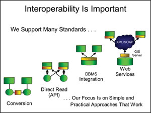
Interoperability
Interoperability is important to this new environment. ESRI has long supported open standards for data sharing and open services. An example: Fifteen years ago, we simplified the direct reading of data with the publishing of the shapefile and integrating data in various database management systems (DBMSs), but the Web services platform for interoperability is much stronger. The use of XML and Simple Object Access Protocol (SOAP) allows us to very quickly interchange between different types of services and integrate them. Our focus on standards will be a practical approach that really works.
OGC gis web services 的定义以及要求:http://www.opengeospatial.org/resource/products;http://www.ogc-services.net/?page=2
WMS:定义及概念例子
The Web Map Service (WMS) implementation specification is a standard that describes how mapped information should be communicated on the internet. The Open Geospatial Consortium has come up with a number of versions of the WMS standard. Currently, this site works with WMS versions 1.0.0, 1.1.0, and 1.1.1.
http://wms-sites.com/
http://columbo.nrlssc.navy.mil/ogcwms/servlet/WMSServlet?REQUEST=ServiceLinks, 在任何客户端都不允许操作 ,但可以看,
在arcmap 中的应用;http://columbo.nrlssc.navy.mil/ogcwms/servlet/WMSServlet/Austin_TX_Maps.wms?
WFS;定义及概念例子
USGS Framework Web Feature Services:http://frameworkwfs.usgs.gov/
access :http://frameworkwfs.usgs.gov/framework/wms/cubexplor.cgi
http://frameworkwfs.usgs.gov/framework/wms/cubexplor.cgi?clickMode=zoomIn&layerToQuery=(value+of+%22Layers%22+field)&pixelSensitivity=3&featureCount=5&operation=none&dataStores=USGS+Framework+Layers&themes=Government+Units+(High+Resolution)&layers=County+or+equivalent&styles=(default)&newScale=5.88M&newX=-104.7641393&newY=37.904877626&predefinedLocations=(choose)&newImageWidth=800&newImageHeight=500&newQuality=MEDIUM&newSrs=NAD83+%2F+Pennsylvania+North+(EPSG%3A32128)&whereClauses=&sldUrl=&layersToPlot=County+or+equivalent|State+or+territory|Point+High|Roads|Flowline+High|Line+High|Waterbody+High|Area+High&action=showMainPage&actionPointX=0&actionPointY=0&boxRatio=0¤tX=-104.7641393¤tY=37.904877626¤tScale=5.88M¤tImageWidth=800¤tImageHeight=500¤tSrs=EPSG%3A4326¤tQuality=MEDIUM
可以查询,copy 等操作
http://frameworkwfs.usgs.gov/
WCS:定义及概念例子
http://nsidc.org/cgi-bin/atlas_north?service=WMS&request=GetCapabilities&version=1.1.1
http://nsidc.org/cgi-bin/atlas_north?service=WCS&request=GetCapabilities&version=1.1.1
WPS:定义及概念例子
A Web Processing Service provides access to calculations or models which operate on spatially referenced data. The data required by the service can be available locally, or delivered across a network using data exchange standards such as GML or GDAS. The calculation can be as simple as subtracting one set of spatially referenced numbers from another (e.g. determining the difference in influenza cases between two different seasons), or as complicated as a global climate change model.
This specification is intended to provide a mechanism to identify the spatially-referenced data required by the calculation, initiate the calculation, and manage the output from the calculation so that it can be accessed by the client. The Web Processing Service is targeted at vector GIS data, not at raster image processing.
http://52north.org/maven/project-sites/wps/52n-wps-site/
demo:http://52north.org/maven/project-sites/wps/52n-wps-site/demos.html
2、技术方法:SOA,WSDL,REST
REST: http://www.xfront.com/REST-Web-Services.html
DEMO:http://www.thomas-bayer.com/rest-demo.htm
ARCGIS SERVER SUPPORT BUTH:
http://sampleserver2.arcgisonline.com/ArcGIS/rest/services/Elevation/ESRI_Elevation_World/GPServer
3、成功例子:
GOOGLE MAP
The National Geologic Map Database Project: Overview and Progress :
http://pubs.usgs.gov/of/2004/1451/soller/index.html
google map services:
yahoo map web services: http://developer.yahoo.com/maps/
http://developer.yahoo.com/traffic/
动态交通数据real-time traffic service :http://www.tih.org.uk/index.php/Directory
动态交通数据: http://datex2.tistrafficinfo.com/england/
动态公交信息应用:
http://lorry.its.washington.edu/busview/realtime/all/welcome.jsp?height=1024
动态停车场信息:
http://www.parkingspacenow.smgov.net/
动态交通信息http://www.traffic.com:rest
应用:http://www.traffic.com/Houston-Traffic/Houston-Traffic-Reports.html?ct=ma_list
5、目前可以实现的功能:
成功应用:http://www.traffic-england.co.uk/
重点: dll 发布成web services 和web services的跨平台
工具:
ARCGIS 的概念 和例子以及可实现的服务以及 符合OGC标准的要求,成功服务器端和客户端
ARCVIEW SERVICRES: http://www.geographynetwork.com/
Web services: http://resources.esri.com/arcgisserver/index.cfm?fa=samples
sharpmap .net deom 可以
openlayers 的例子的概念,例子 http://openlayers.org/
比较特别的功能:允许客户端发广告:http://www.urmap.com/adservice /Advertise_03.html?utm_source=UrMapsite&utm_medium=textlink&utm_term=advertiser
others services and application
http://www.microsoft.com/virtualearth/
http://www.acme.com/jef/transpac2005/
http://www.microsoft.com/MapPoint/en-us/default.aspx#
http://www.lib.unc.edu/reference/gis/index.html
online tools
http://www.lib.unc.edu/reference/gis/online_mapping_tools/index.html
web services 。net
http://www.webservicex.net/WCF/Services.aspx?CID=3
http://www.ddsgeo.de/produkte/software-tools.html
我们在多模式导航里的整体设计和思路以及考虑,实现的功能
6、我们需要做的
匹配算法有可以依靠web services 可实现的功能和框架体系

 浙公网安备 33010602011771号