


Hou Tao, Fan Xiangtao, Guohuadong, Li Hongga, Nie Yueping
State Key Laboratory of Remote Sensing Science, Institute of Remote Sensing Applications
Chinese Academy of Sciences, P.O.X 9718, Beijing, China
Email: wuhanht@sohu.comAs a synthesize technology, has been springing up in the end of 20 century, Virtual Reality technology integrates several latest information technology such as computer graph, artificial intelligence, Multi-media, Sensor surveying and parallel processing technology. Virtual Reality technique provides a new interface tool and interactive operation environment and immersive environment for the representation and real-time simulation of large-scale virtual scene.
In Hebei Province, northeast of China, Shanhaiguan Great Wall preserved in good condition, and it has historic research and appreciation value. This paper presents the research works, such as build 3D terrain and scene model of existent old castle at Shanhaiguan region based on the 1:50,000 scale DEM, high resolution Quickbird image, historical records and pictures on the sport, and attempt to reconstruct of ancient Great Wall and old castle scene at this region. The research works indicates that Virtual Reality technology integrated the data of remote sensing and correlative information will provide a new tool and verifying methods in archaeology. By viewing the Virtual scene and interactively controlling the models in the scene, archaeologist can study the historical change of the Great Wall and the surrounding environment.
Key Words: Virtual Reality technology, 3D terrain model, interactive control, Reconstruction
Introduction
As a synthesize technology, has been springing up in the end of 20 century, Virtual Reality technology integrating several latest information technology such as computer graph, artificial intelligence, Multi-media, Sensor surveying and parallel processing technology provides us a strong support to create and experience virtual world. So the development of computer technology is greatly advanced. In recent years, Virtual Reality technique not only is utilized in many fields such as plan of city, real estate, military, medicine, design of architecture, archeology, art and entertainment, but also brings huge economic benefit to society.
The information which the research works for virtual heritage will express are multi-dimensional, and need the authenticity of history, the art expression of culture and the reality of environment [1]. Satisfying this kind of information expression, the Virtual Reality technology is the most suitable to be adopted because of the character and function of VR technology. For example, applying the construction of the 3D scenes and the display helmet processes the visual simulation for archeology. The feeling and hearing are simulated separately by the use of glove of feeling and the sound card and other devices.
From 1997 to 2002 the UCLA Cultural Virtual Reality Laboratory created a digital model of the Roman Forum. The model contains the 22 major elements of the Forum including the discuss hall of the elder, monument etc [3].
The display of ancient Greek sanctuary in
The historical situation of Study Site
The project of the building the Great Wall lasted more than two thousand years from the Spring and Autumn Period to Ming Dynasty. Located the east of the Great Wall, Shanhaiguan Great Wall whose distance is 26 kilometers starts from the Laolongtou at the south, traverses the Shanhaiguan Ancient City and reaches the JiuMenKou like a huge dragon connecting mountain, sea and passes. Mainly composed by the City Wall, Centered by the Shanhaiguan Ancient City, Supplemented by 10 Big Passes, 5 Defend Cities, 23 Enemy Platforms, 14 Fight Platforms, 10 Signal Fire Platforms and other establishments such as fort, guard place etc, Shanhaiguan area become the famous military fortress [5].
The First Pass under Heaven Tower is the east gate in the ShanHaiguan ancient city. It is the most imposing tower in the city and lifts on the Great Wall like a coiling dragon and crouching tiger. On the north and south, there is Weiyuan Lou Tower, Jingbian Lou Tower, Muying Lou Tower and Linlu Lu Tower. The five towers like five tigers guarding the east.
Located on the shore of the Bohai Sea about 4 kilometers away from the city of Shanhaiguan, Laolongtou is the starting point of the Ming-Dynasty Great Wall. Set against the mountain and facing the sea, the 11 meters high wall was constructed with stone at its base, with a section of about 25 meters extending down to the sea. It is called ‘The Stone Wall Entering the sea’ and was built by the commander of the garrison troops in the Ming Dynasty. The huge stone wall looks like a dragon’s head into the vast sea to play with the waves, hence the name Laolongtou(the meaning of old dragon’s head). Laolongtou consists of the wall extending to the sea, Jinglutai and Chenghailou which is the symbol building.
It has been 600 years since the building of the Shanhaiguan Great Wall. Because of the erosion of the wind and rain, destroy of the war and the devastation the activities of human being, some sections are collapsed and even disappeared. In order to restore the original visage the ancient Great Wall, reconstruction of the ancient site are processed by applying the Virtual Reality technology, searching for authentic evidence and scientifically inferring on the base of historical literature and information of archeology.
Methodology and technologies of reconstruction
This paper takes ancient Great Wall in shanhaiguan area as test site to illustrate the virtual reality designing and implementing method of the reconstruction of the ancient site.
The main object of this research is: according to the history records and archeological information, combining with principles and results from relating subjects like geography, geology and architecture etc., with certified evidence or scientific reasonable deduction, to reconstruct the site of the ancient Great Wall using the virtual reality technology.
The main research works include some aspects as below:
1) Gathering 3D spatial information of cultural relics and ancient site. Using technologies including photograph measuring, GPS, remote sensing, image processing and computer visualization synthetically to obtain the 3D spatial data.
2) Establishing 3D data model of cultural relics and ancient ruins. Combining virtual reality technology and traditional 2D/3D GIS data model, the 3D database of cultural relics and ancient ruins is constructed.
3) Using actual-collected textures and materials for the 3D model, real-like drawing can be accomplished.
4) Real-time interactive technology studying. Applying distributed network technology and LOD technology, according to the characteristics of human vision and perception, to implement fast and real-time 3D image computing and drawing, smoothly navigating and real-time interactive.
5) Virtual reality technology researches.
The detailed steps of reconstruction are listed as below:
1) Obtain the remote sensing image and DEM of Shanhaiguan area. After transformation and correction, superpose it to the digital elevation model to form the basic 3D simulation terrain of this area.
2) The main construction of the Great Wall is the rampart, with other buildings of different form, scale, and usage such as garrison, pass city, city platform, enemy platform, fight platform smoke frusta. According to the collected information, construct the 3D model of city wall, enemy platform, pass and tower.
3) Putting the 3D building model in the basic 3D simulation terrain to form the relatively complete simulation environment.
4) Construct the model attributes database of virtual environment. According to the association between the construction of key words and the model database, achieve the object’s attributes-query function.
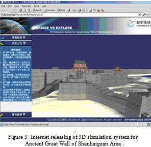
5) Based on the steps listed above, operating the functions of object-select and object-query, fixed or custom path navigating in 3D simulation environment with the scene-driving program. Using the developed ActiveX control, which enhances 3D rendering in web-browser and interactive operation, to set up the full, accurate and vivid demonstration web page of the ancient Great Wall in Shanhaiguan and achieve fast responses based on the relatively small data configuration to make the public appreciate the 3D scene of the grand and majestic ancient Great Wall of Shanhaiguan through internet.
The technique route can be referenced by figure 2.
Conclusion and Discussion
The Shanhaiguan Great Wall 3D simulation System, which has been set up by our research works, exhibits the appearance of ancient cultural relic of this area. This kind of technique will break through spatial and temporal limit and provides “zero distance” opportunity for people to view and emulate. The consciousness of people for cultural relic protecting and visiting will be excitated extremely, and it also prolong the life of ancient site. Cultural relic and site exhibiting and correlative information internet releasing using virtual reality technology will integrate different king of information of ancient site, implement resource sharing, promulgate traditional culture to public people, and never affects safety of cultural relic and site.
The research works indicate that, according to the 3D virtual scene established by our research works, which making use of virtual reality technology integrated remote sensing data and relevant historical datum, adopt methods of 3D simulation and interactive control to investigate historical change of ancient environment and site, will provide new information and validate method for archaeological research works, and also will offer new technical means for protection and propaganda of cultural relic and heritage.
The discovery of ancient cultural relics is not isolated; synthetic analysis should be done during the research. So the further research will be to enhance and improve the synthetic analysis function of the archeological research under the simulation environment, including the possible spatial distribution and the dynamic analysis of time series. To fully bring the virtual reality technology into archeology field, and make it more useful to the archeology decision-making and deduction.
Acknowledgment
This work was partially supported by the National Key Technologies R&D ProgramOlympic Games Dedicated Projects "Research of dynamic monitor for Beijing Olympic Green Environment"(Grant No. 2002BA904B07). Special thanks to Wangchanglin and Songyang for their support in words check.
References
[1] Huadong Guo, 2003,Recognition of information of human being hermitage on space, proceedings of Xiangshan conference, Beijing
[2] Qmigh, the digital reconstruction of Bamiyan great Buddha, www.southcn.com/travel/
[3] THE DIGITAL ROMAN FORUM PROJECT OF THE UCLA CULTURAL VIRTUAL REALITY LABORATORY, International Archives of the Photogrammetry, Remote Sensing and Spatial Information Sciences, Vol. XXXIV-5/W10, Bernard Frischer, Diane Favro, Dean Abernathy, Monica De Simoned.
[4] Kohei SAKAMOTO, Hirofumi CHIKATSU, 2002, Computer Reconstruction of the Past Objects and Visual Animation of Landscape, International Archives of Photogrammetry and Remote Sensing, Vol.XXXIV, Part5/W3.


 浙公网安备 33010602011771号