
uniapp使用map显示多条polyline
参考链接:
基础知识:
坐标系
- wgs-84:地球坐标系(国际通用)--- gps
- gcj02:火星坐标系(wgs84加密)国内必须用加密后的坐标
- bd09:百度坐标系(百度地图使用)
- wgs-84 和 gcj02 之间可以用java代码转换。
微信小程序使用<map>
- api: wx.getLocation(Object object) https://developers.weixin.qq.com/miniprogram/dev/api/location/wx.getLocation.html
- 地图相关使用的坐标格式应为 gcj02。
- 若使用该接口,需要在 app.json 中进行声明,否则将无法正常使用该接口
- 使用前还需要先通过类目审核,再在小程序管理后台,「开发」-「开发管理」-「接口设置」中自助开通该接口权限。
经度(竖):0~180°
纬度(横):0~90°
实际api中使用的参数通常是(纬度,经度)而不是先经度后纬度。
布局代码
<map id="myMap" :latitude="myLatitude" :longitude="myLongitude" :scale="scale" :polyline="polyline" show-location :include-points="polyline[0].points"></map>
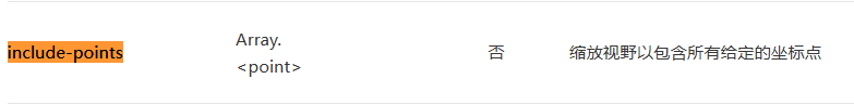
最重要的参数是 polyline 和 include-points
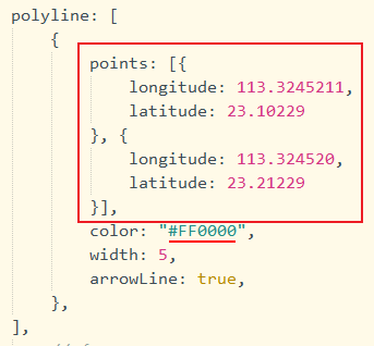
return {
    // 39.908823,116.397470(北京)
    myLatitude: 39.908823, //中心纬度
    myLongitude: 116.397470, //中心经度
    scale: 12, //取值范围为3-20
    polyline: [
        {
            points: [{
                longitude: 113.3245211,
                latitude: 23.10229
            }, {
                longitude: 113.324520,
                latitude: 23.21229
            }],
            color: "#FF0000",
            width: 5,
            arrowLine: true,
        },
        // {
        //     points: [{
        //         longitude: 113.3255211,
        //         latitude: 23.10229
        //     }, {
        //         longitude: 113.325520,
        //         latitude: 23.21229
        //     }],
        //     color: "#0000ff",
        //     width: 5,
        //     arrowLine: true,
        // },
    ],
}
微信文档参数解释如下:
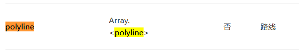
polyline 是数组,有一条路线就增加一个 { } ,对象属性有 points, color, width, arrowLine
points也是一个数组,多个坐标点放在这个数组里,arrowLine 负责箭头显示与否。
❗❗❗ include-points 也是数组,以上图为例,include-points绑定的数据应该是polyline[0].points 。直接绑定 polyline 没有效果。
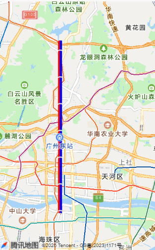
现在的效果如下

白色的就是箭头

如果要显示多条路线,在polyline里增加新的对象
polyline: [
    {
        points: [{
            longitude: 113.3245211,
            latitude: 23.10229
        }, {
            longitude: 113.324520,
            latitude: 23.21229
        }],
        color: "#FF0000",
        width: 5,
        arrowLine: true,
    },
    {
        points: [{
            longitude: 113.3255211,
            latitude: 23.10229
        }, {
            longitude: 113.325520,
            latitude: 23.21229
        }],
        color: "#0000ff",
        width: 5,
        arrowLine: true,
    },
]
显示效果如下(因为两条路径坐标一样,所以路径一样):

 浙公网安备 33010602011771号