leetcode 签到1162. 地图分析
题目
- 地图分析
你现在手里有一份大小为 N x N 的『地图』(网格) grid,上面的每个『区域』(单元格)都用 0 和 1 标记好了。其中 0 代表海洋,1 代表陆地,你知道距离陆地区域最远的海洋区域是是哪一个吗?请返回该海洋区域到离它最近的陆地区域的距离。
我们这里说的距离是『曼哈顿距离』( Manhattan Distance):(x0, y0) 和 (x1, y1) 这两个区域之间的距离是 |x0 - x1| + |y0 - y1| 。
如果我们的地图上只有陆地或者海洋,请返回 -1。
示例 1:
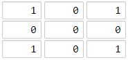
输入:[[1,0,1],[0,0,0],[1,0,1]]
输出:2
解释:
海洋区域 (1, 1) 和所有陆地区域之间的距离都达到最大,最大距离为 2。
示例 2:
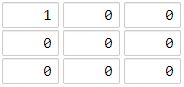
输入:[[1,0,0],[0,0,0],[0,0,0]]
输出:4
解释:
海洋区域 (2, 2) 和所有陆地区域之间的距离都达到最大,最大距离为 4。
提示:
1 <= grid.length == grid[0].length <= 100
grid[i][j] 不是 0 就是 1
来源:leetcode
链接:https://leetcode-cn.com/problems/as-far-from-land-as-possible/
思路
大眼一瞅,我的笨方法可以写啊。

不过三重循环。。不会超时吗?

提交一下

果然超时了。。

不着急,赶紧去康题解。大部分都是染色
https://leetcode-cn.com/problems/as-far-from-land-as-possible/solution/pythonbfsjian-dan-yi-dong-by-luanz/
拉过来个代码看看
超时代码
class Solution:
    def maxDistance(self, grid):
        a=[]
        num=0
        for i in range(len(grid)):
            for j in range(len(grid)):
                if grid[i][j]==1:
                     a.append(i)
                     a.append(j)
                if grid[i][j] == 0:
                   num+=1
        b=[]
        if num==pow(len(grid),2):
            return  -1
        for i in range(len(grid)):
            for j in range(len(grid)):
                if grid[i][j]==0:
                    k=0
                    M=100000000
                    while k+1<len(a):
                        if abs(a[k]-i)+abs(a[k+1]-j)<M :
                            M=abs(a[k]-i)+abs(a[k+1]-j)
                        k += 2
                    b.append(M)
        if len(b)==0:
            return  -1
        return max(b)
代码
class Solution:
    def maxDistance(self, grid: List[List[int]]) -> int:
        m, n = len(grid), len(grid[0])
        nodes = [(i, j) for i in range(m) for j in range(n) if grid[i][j]]  #提取陆地坐标列表
        if not nodes or len(nodes)==m*n:#是否为纯陆地或纯海洋
           return -1

        def isValid(x, y):#判断给定坐标是否有效
            return 0<= x <m and 0<= y <n

        depth = -1
        delt = [(0,1),(0,-1),(1,0),(-1,0)]
        while nodes:#处理当前层信息
            depth += 1
            tmp = []#存储待探索海洋坐标
            for x, y in nodes:#对当前每个待探坐标分别处理4个方向
                for d in delt:
                    newx, newy = x+d[0], y+d[1]
                    if isValid(newx, newy) and not grid[newx][newy]:#新点是海洋且未探测
                        tmp.append((newx, newy))
                        grid[newx][newy] = 1
            nodes = tmp
        return depth
作者:luanz
链接:https://leetcode-cn.com/problems/as-far-from-land-as-possible/solution/pythonbfsjian-dan-yi-dong-by-luanz/
路漫漫其修远兮,吾将上下而求索。


 浙公网安备 33010602011771号