
openlayer CGCS2000 EPSG:4490
接上一篇 openlayer投影转换 有了新问题,CGCS2000(EPSG:4490) 坐标转换有问题。
后来发现应该将问题简化为 “openlayer 设置CGCS2000 view”。
资料1:用openlayer加载arcgis发布的wmts图层
资料2:OpenLayers 6 如何优雅的使用天地图WMTS服务“经纬度投影(CGCS2000)”和“球面墨卡托投影(EPSG:3857)”
问题解决的总结:
要点1:
projection的 Extent WorldExtent 属性都要赋值,缺一不可
代码如下:
var projection4490 = new ol.proj.get('EPSG:4490');

//下面这俩 extent 都必须有
projection4490.setExtent([-180,-90,180,90]);
projection4490.setWorldExtent([-180,-90,180,90]);
要点2:
CGCS2000是地理坐标系,单位是经纬度,所以view 的 center 属性直接使用经纬度,如下所示
center:[0, 0],
3857是投影坐标系,单位不是经纬度,所以view 的 center 属性需要转换一下,如下所示
center:ol.proj.transform([0, 0], 'EPSG:4326', 'EPSG:3857'),


另外不知道为啥,加载的本地 geojson 数据在第一个map使用后,需要再次赋值才能给 第二个map使用~~~  没理解~
代码:
<!DOCTYPE html>
<html xmlns="http://www.w3.org/1999/xhtml">
<head>
<meta http-equiv="Content-Type" content="text/html; charset=utf-8"/>
    <title></title>
    <script src="./lib/ol/ol.js"></script>
    <script src="./lib/ol/proj4.js"></script>
    <link href="./css/ol.css" rel="stylesheet" />
    <style type="text/css">
        body,html,div{
            border:none;padding:0;margin:0;
            font-size:14px;
            font-family:"微软雅黑";
        }
        #menu{
            width:100%;
            height:20px;
            padding:5px 10px;
            left:10px;
        }
        .container{
            float:left;
            width:45%;
            height:500px;
            margin:0 5px;
            margin-left:10px;
        }
        .map{
            float:left;
            width:100%;
            height:100%;
            border:1px dashed red;
        }
    </style>
    <script type="text/javascript">
        window.onload = function () {

            //初始化矢量图层
            var vector = new ol.layer.Vector({
                source: new ol.source.Vector({
                    url: '/ol/data/geojson/countries-110m.json',
                    format:new ol.format.GeoJSON()
                })
            });
            //osm tile layer
            var tile = new ol.layer.Tile({
                    source:new ol.source.OSM()
                })

            //wmts layer
            //设置地图投影
            var projection4326 = new ol.proj.Projection({
                code: 'EPSG:4326',//投影编码
                units: 'degrees',
                axisOrientation: 'neu'
            });
            var layer_wmts = new ol.layer.Tile({
                source: new ol.source.WMTS({
                    //服务地址
                    url: 'http://localhost:8088/geoserver/gwc/service/wmts',
                    layer: 'nurc:Img_Sample',
                    //切片集
                    matrixSet: 'EPSG:4326',
                    format: 'image/png',
                    projection: projection4326,
                    //切片信息
                    tileGrid: new ol.tilegrid.WMTS({
                        tileSize: [256, 256],
                        extent: [-180.0, -90.0, 180.0, 90.0],//范围
                        origin: [-180.0, 90.0],
                        resolutions: [0.703125, 0.3515625, 0.17578125, 0.087890625, 0.0439453125, 0.02197265625, 0.010986328125, 0.0054931640625, 0.00274658203125, 0.001373291015625, 6.866455078125E-4, 3.4332275390625E-4, 1.71661376953125E-4, 8.58306884765625E-5, 4.291534423828125E-5, 2.1457672119140625E-5, 1.0728836059570312E-5, 5.364418029785156E-6, 2.682209014892578E-6, 1.341104507446289E-6, 6.705522537231445E-7, 3.3527612686157227E-7],
                        matrixIds: ['EPSG:4326:0', 'EPSG:4326:1', 'EPSG:4326:2', 'EPSG:4326:3', 'EPSG:4326:4', 'EPSG:4326:5', 'EPSG:4326:6', 'EPSG:4326:7', 'EPSG:4326:8', 'EPSG:4326:9', 'EPSG:4326:10', 'EPSG:4326:11', 'EPSG:4326:12', 'EPSG:4326:13', 'EPSG:4326:14', 'EPSG:4326:15', 'EPSG:4326:16', 'EPSG:4326:17', 'EPSG:4326:18', 'EPSG:4326:19', 'EPSG:4326:20', 'EPSG:4326:21'],
                    }),
                    //
                    style: 'raster',
                    wrapX: true
                })
            });

            //######   map1    ######
            //projection3857
            var projection3857 = ol.proj.get('EPSG:3857');
            var view3857 =new ol.View({
                    projection: projection3857,
                    resolutions: [65536, 32768, 16384, 8192, 4096, 2048, 1024, 512,256],
                    center:ol.proj.transform([0, 0], 'EPSG:4326', 'EPSG:3857'),
                    zoom:0
                })

            //初始化地图
            var map1 = new ol.Map({
                layers: [
                    tile,
                    vector,
                    layer_wmts
                ],
                //渲染方式
                render: 'canvas',
                target: 'map1',
                view: view3857
            });
            //显示网格参考
            var graticule = new ol.Graticule({
                map: map1
            })

            //######   map2   ######
            //projection4490
            proj4.defs("EPSG:4490", "+proj=longlat +ellps=GRS80 +no_defs");


            var projection4490 = new ol.proj.get('EPSG:4490');

            //下面这俩 extent 都必须有
            projection4490.setExtent([-180,-90,180,90]);
            projection4490.setWorldExtent([-180,-90,180,90]);

            var  view4490 = new ol.View({
                    projection: projection4490,
                    center:[0, 0],
                    zoom:2
                })

            //如果不在这里再次赋值vector   那么map2 里就无法加载出来这个geojson.....什么鬼
            vector = new ol.layer.Vector({
                source: new ol.source.Vector({
                    url: '/ol/data/geojson/countries-110m.json',
                    format:new ol.format.GeoJSON()
                })
            });


            //初始化地图
            var map2 = new ol.Map({
                layers: [
                    tile,
                    vector,
                    layer_wmts
                ],
                //渲染方式
                render: 'canvas',
                target: 'map2',
                view: view4490
            });
            //显示网格参考
            var graticule = new ol.Graticule({
                map: map2
            })

        };

    </script>
</head>
<body>

    <div class="container">
        <label>投影坐标系(EPSG:3857)</label>
        <div id="map1" class="map"></div>
    </div>
    <div class="container">
        <label>投影坐标系(EPSG:4490)</label>
        <div id="map2" class="map"></div>
    </div>

</body>
</html>
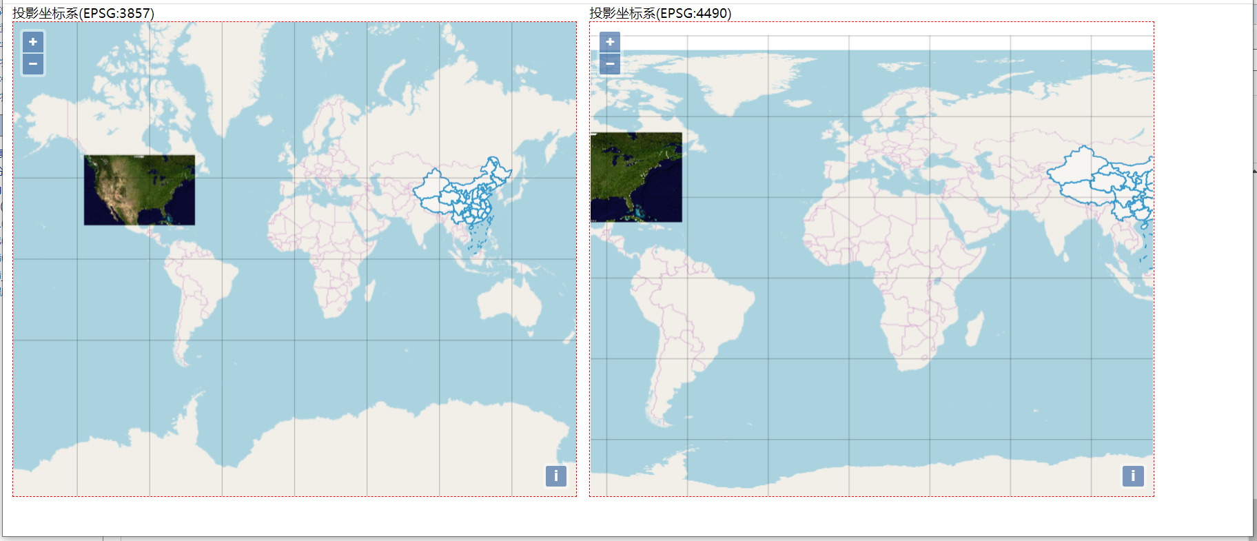
效果如下:

 浙公网安备 33010602011771号