


arcgis server for .NET学习转载4
http://www.cnblogs.com/hll2008/archive/2008/08/17/1269650.html
目的:
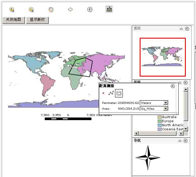
1.距离测量功能。
准备:
1.(一、三)的工程,具体见前篇。
开始:
1.新建名为Measure.ascx的用户控件,并且实现ICallbackEventHandler接口,具体代码如下:
目的:
1.距离测量功能。
准备:
1.(一、三)的工程,具体见前篇。
开始:
1.新建名为Measure.ascx的用户控件,并且实现ICallbackEventHandler接口,具体代码如下:
1 namespace MappingApp
2 {
{
3 public partial class Measure : System.Web.UI.UserControl, ICallbackEventHandler
4 {
{
5 protected void Page_Load(object sender, EventArgs e)
6 {
7
8 }
}
9
10 #region ICallbackEventHandler 成员
11
12 //负责把结果回传给客户端
13 public string GetCallbackResult()
14 {
15 throw new Exception("The method or operation is not implemented.");
16 }
17
18 //负责从客户端javascript传来的参数
19 public void RaiseCallbackEvent(string eventArgument)
20 {
21 throw new Exception("The method or operation is not implemented.");
22 }
23
24 #endregion
25 }
26 }
}
2. 加入具体的线距离测量和面积测量功能代码,具体的代码和说明如下:namespace MappingApp2
{
3
public partial class Measure : System.Web.UI.UserControl, ICallbackEventHandler4
{5
protected void Page_Load(object sender, EventArgs e)6
{7
8
}9
10
#region ICallbackEventHandler 成员11
12
//负责把结果回传给客户端13
public string GetCallbackResult()14
{15
throw new Exception("The method or operation is not implemented.");16
}17
18
//负责从客户端javascript传来的参数19
public void RaiseCallbackEvent(string eventArgument)20
{21
throw new Exception("The method or operation is not implemented.");22
}23
24
#endregion25
}26
} 1namespace MappingApp
2{
3 //地图单位
4 public enum MapUnit
5 {
6 Resource_Default, Degrees, Feet, Meters //默认,度,码,米
7 }
8
9 //测量单位
10 public enum MeasureUnit
11 {
12 Feet, Kilometers, Meters, Miles //码,千米,米,英里
13 }
14
15 //区域单位
16 public enum AreaUnit
17 {
18 Acres, Sq_Feet, Sq_Kilometers, Sq_Meters, Sq_Miles //英亩,平方码,平方千米,平方米,平方英里
19 }
20
21 public partial class Measure : System.Web.UI.UserControl, ICallbackEventHandler
22 {
23 MapResourceManager m_resourceManger;
24 IMapFunctionality m_mapFunctionality;
25 //页面
26 private Page m_page;
27 //客户端代码段
28 public string m_callbackInvocation = "";
29 //地图控件ID
30 private string m_mapBuddyId = "Map1";
31 //用户控件id
32 public string m_id;
33 //地图控件
34 private Map m_map;
35 //默认地图单位
36 private MapUnit m_FallbackMapUnit = MapUnit.Degrees;
37 private MapUnit m_mapUnits;
38 //
39 private MapUnit m_startMapUnits = MapUnit.Degrees;
40 //默认测量单位
41 public MeasureUnit m_measureUnits = MeasureUnit.Miles;
42 //默认区域单位
43 public AreaUnit m_areaUnits = AreaUnit.Sq_Miles;
44 //数字精确到4位
45 private double m_numberDecimals = 4;
46
47 protected void Page_Load(object sender, EventArgs e)
48 {
49 //控件id
50 m_id = this.ClientID;
51 //页面
52 m_page = this.Page;
53 if (m_mapBuddyId == null || m_mapBuddyId.Length == 0)
54 {
55 m_mapBuddyId = "Map1";
56 }
57 //获取map控件
58 m_map = m_page.FindControl(m_mapBuddyId) as Map;
59 //获取MapResourceManager控件
60 m_resourceManger = m_page.FindControl(m_map.MapResourceManager) as MapResourceManager;
61 //通过GetCallbackEventReference生成客户端调用的javascript方法段
62 m_callbackInvocation = m_page.ClientScript.GetCallbackEventReference(this, "argument", "processCallbackResult", "context", true);
63 }
64
65 //
66 protected void Page_PreRender(object sender, EventArgs e)
67 {
68 GetMeasureResource();
69 }
70
71 private void GetMeasureResource()
72 {
73 string primeResource = m_map.PrimaryMapResource;
74 IEnumerable mapResources = m_resourceManger.GetResources();
75 IEnumerator resEnum = mapResources.GetEnumerator();
76
77 resEnum.MoveNext();
78
79 IGISResource resource;
80 if (primeResource != null && primeResource.Length > 0)
81 {
82 resource = m_resourceManger.GetResource(primeResource);
83 }
84 else
85 {
86 resource = resEnum.Current as IGISResource;
87 }
88
89 if (resource != null)
90 {
91 m_mapFunctionality = (IMapFunctionality)resource.CreateFunctionality(typeof(IMapFunctionality), "mapFunctionality");
92 }
93 }
94
95 ICallbackEventHandler 成员
163
164 //根据请求字符串进行不同的测量
165 public string ProcessMeasureRequest(NameValueCollection queryString)
166 {
167 if (m_mapFunctionality == null)
168 {
169 GetMeasureResource();
170 }
171 object o = Session["MeasureMapUnits"];
172 if (o != null)
173 {
174 m_mapUnits = (MapUnit)Enum.Parse(typeof(MapUnit), o.ToString());
175 }
176 else if (m_startMapUnits == MapUnit.Resource_Default)
177 {
178 //获取默认地图单位
179 m_mapUnits = GetResourceDefaultMapUnit();
180 }
181 else
182 {
183 m_mapUnits = m_startMapUnits;
184 }
185
186 //请求参数
187 string eventArg = queryString["EventArg"].ToLower();
188 string vectorAction = queryString["VectorAction"].ToLower();
189 string[] coordPairs, xys;
190 //坐标字符串
191 string coordString = queryString["coords"];
192 if (coordString == null && coordString.Length == 0)
193 {
194 coordString = "";
195 }
196 //坐标字符串分割
197 coordPairs = coordString.Split(char.Parse("|"));
198 //地图单位
199 string mapUnitString = queryString["MapUnits"];
200 if (mapUnitString != null && mapUnitString.Length > 0)
201 {
202 m_mapUnits = (MapUnit)Enum.Parse(typeof(MapUnit), mapUnitString);
203 }
204 Session["MeasureMapUnits"] = m_mapUnits;
205 //测量单位
206 string measureUnitString = queryString["MeasureUnits"];
207 if (measureUnitString != null && measureUnitString.Length > 0)
208 {
209 m_measureUnits = (MeasureUnit)Enum.Parse(typeof(MeasureUnit), measureUnitString);
210 }
211 //区域单位
212 string areaUnitstring = queryString["AreaUnits"];
213 if (areaUnitstring != null && areaUnitstring.Length > 0)
214 {
215 m_areaUnits = (AreaUnit)Enum.Parse(typeof(AreaUnit), areaUnitstring);
216 }
217
218 //输出内容字符串
219 string response = "";
220 PointCollection points = new PointCollection();
221 PointCollection dPoints = new PointCollection();
222 ArrayList distances = new ArrayList();
223 double totalDistance = 0;
224 double segmentDistance = 0;
225 double area = 0;
226 double perimeter = 0;
227 double roundFactor = Math.Pow(10, m_numberDecimals);
228 double xD, yD, tempDist, tempDist2, tempArea, x1, x2, y1, y2;
229
230 //动作为添加点
231 if (vectorAction == "addpoint")
232 {
233 //坐标点大于1个时,就是保证是一条线
234 if (coordPairs != null && coordPairs.Length > 1)
235 {
236 for (int i = 0; i < coordPairs.Length; i++)
237 {
238 xys = coordPairs[i].Split(char.Parse(":"));
239 //像素坐标转换成地理坐标
240 points.Add(Point.ToMapPoint(Convert.ToInt32(xys[0]), Convert.ToInt32(xys[1]), m_map.GetTransformationParams(ESRI.ArcGIS.ADF.Web.Geometry.TransformationDirection.ToMap)));
241
242 if (i > 0)//第二个坐标点的时候
243 {
244 if (m_mapUnits == MapUnit.Degrees)//地图单位为度的时候
245 {
246 //计算与前一个点的距离,分段距离
247 tempDist = DegreeToFeetDistance(points[i - 1].X, points[i - 1].Y, points[i].X, points[i].Y);
248 //度转成码
249 y1 = DegreeToFeetDistance(points[i].X, points[i].Y, points[i].X, 0);
250 //度转成码
251 x1 = DegreeToFeetDistance(points[i].X, points[i].Y, 0, points[i].Y);
252 dPoints.Add(new Point(x1, y1));
253 //单位换算
254 segmentDistance = ConvertUnits(tempDist, MapUnit.Feet, m_measureUnits);
255 }
256 else//地图单位为米的时候
257 {
258 xD = Math.Abs(points[i].X - points[i - 1].X);
259 yD = Math.Abs(points[i].Y - points[i - 1].Y);
260 //计算2个坐标之间的距离
261 tempDist = Math.Sqrt(Math.Pow(xD, 2) + Math.Pow(yD, 2));
262 //单位换算
263 segmentDistance = ConvertUnits(tempDist, m_mapUnits, m_measureUnits);
264
265 }
266
267 //把分段距离添加到distances
268 distances.Add(segmentDistance);
269 //计算总距离
270 totalDistance += segmentDistance;
271 //只显示4位小数
272 segmentDistance = Math.Round(segmentDistance * roundFactor) / roundFactor;
273 totalDistance = Math.Round(totalDistance * roundFactor) / roundFactor;
274 }
275 else//第一个坐标点的时候
276 {
277 if (m_mapUnits == MapUnit.Degrees)
278 {
279 //度转成码
280 y1 = DegreeToFeetDistance(points[i].X, points[i].Y, points[i].X, 0);
281 x1 = DegreeToFeetDistance(points[i].X, points[i].Y, 0, points[i].Y);
282 dPoints.Add(new Point(x1, y1));
283 }
284 }
285 }
286 }
287
288 //为多边形时
289 if (eventArg == "polygon")
290 {
291 if (points.Count > 2)
292 {
293 if (m_mapUnits == MapUnit.Degrees)
294 {
295 //最后一段的距离计算
296 tempDist = DegreeToFeetDistance(points[points.Count - 1].X, points[points.Count - 1].Y, points[0].X, points[0].Y);
297 tempDist2 = ConvertUnits(tempDist, MapUnit.Feet, m_measureUnits);
298 distances.Add(tempDist2);
299 //加入第一点作为多边形的结束节点
300 dPoints.Add(dPoints[0]);
301 }
302 else
303 {
304 //最后一段的距离计算
305 xD = Math.Abs(points[points.Count - 1].X - points[0].X);
306 yD = Math.Abs(points[points.Count - 1].Y - points[0].Y);
307 tempDist = Math.Sqrt(Math.Pow(xD, 2) + Math.Pow(yD, 2));
308 tempDist2 = ConvertUnits(tempDist, m_mapUnits, m_measureUnits);
309 distances.Add(tempDist2);
310 }
311 //加入第一点作为多边形的结束节点
312 points.Add(points[0]);
313 //总长度+最后一段长度
314 perimeter = totalDistance + tempDist2;
315 //多边形面积计算
316 tempArea = 0;
317 MapUnit mUnits = m_mapUnits;
318 for (int j = 0; j < points.Count - 1; j++)
319 {
320 if (m_mapUnits == MapUnit.Degrees)
321 {
322 x1 = Convert.ToDouble(dPoints[j].X);
323 x2 = Convert.ToDouble(dPoints[j + 1].X);
324 y1 = Convert.ToDouble(dPoints[j].Y);
325 y2 = Convert.ToDouble(dPoints[j + 1].Y);
326 mUnits = MapUnit.Feet;
327 }
328 else
329 {
330 x1 = Convert.ToDouble(points[j].X);
331 x2 = Convert.ToDouble(points[j + 1].X);
332 y1 = Convert.ToDouble(points[j].Y);
333 y2 = Convert.ToDouble(points[j + 1].Y);
334 }
335 //tempArea += tempArea + (x1 + x2) * (y1 - y2);
336 double xDiff = x2 - x1;
337 double yDiff = y2 - y1;
338 tempArea += x1 * yDiff - y1 * xDiff;
339 }
340 tempArea = Math.Abs(tempArea) / 2;
341 //单位换算
342 area = ConvertAreaUnits(tempArea, mUnits, m_areaUnits);
343 //保留4位小数
344 perimeter = Math.Round(perimeter * roundFactor) / roundFactor;
345 area = Math.Round(area * roundFactor) / roundFactor;
346
347 //输出显示内容html
348 response = String.Format("<table cellspacing='0' ><tr><td>Perimeter: </td><td align='right'>{0}</td><td>{1}</td></tr><tr><td>Area:</td><td align='right'>{2}</td><td>{3}</td></tr></table>", perimeter, WriteMeasureUnitDropdown(), area, WriteAreaUnitDropdown());
349 }
350 else
351 {
352 //输出显示内容html,小于3个点时候
353 response = String.Format("<table cellspacing='0' ><tr><td>Perimeter: </td><td align='right'> 0</td><td>{0}</td></tr><tr><td>Area:</td><td align='right'>0 </td><td>{1}</td></tr></table>", WriteMeasureUnitDropdown(), WriteAreaUnitDropdown());
354 }
355 }
356 else
357 {
358 //输出显示内容html,为线的时候
359 response = String.Format("<table cellspacing='0' ><tr><td>Segment: </td><td align='right'>{0} </td><td>{1}</td></tr><tr><td>Total Length:</td><td align='right'>{2} </td><td>{3}</td></tr></table>", segmentDistance, m_measureUnits.ToString(), totalDistance, WriteMeasureUnitDropdown());
360 }
361
362 }
363 //动作为获取坐标
364 else if (vectorAction == "coordinates")
365 {
366 xys = coordPairs[0].Split(char.Parse(":"));
367 Point coordPoint = Point.ToMapPoint(Convert.ToInt32(xys[0]), Convert.ToInt32(xys[1]), m_map.GetTransformationParams(ESRI.ArcGIS.ADF.Web.Geometry.TransformationDirection.ToMap));
368
369 //输出坐标的html显示内容
370 response = String.Format("<table cellspacing='0' ><tr><td>X Coordinate:</td><td align='right'>{0}</td></tr><tr><td>Y Coordinate:</td><td align='right'>{1}</td></tr></table>", (Math.Round(coordPoint.X * roundFactor) / roundFactor).ToString(), (Math.Round(coordPoint.Y * roundFactor) / roundFactor).ToString());
371 }
372 //动作为结束画线
373 else if (vectorAction == "finish")
374 {
375 response = "Shape complete";
376 }
377
378 //把结果内容返回给客户端
379 return String.Format("measure:::{0}:::{1}:::{2}", m_id, vectorAction, response);
380 }
381
382 //输出测量单位选择下拉框
383 public string WriteMeasureUnitDropdown()
384 {
385 System.Text.StringBuilder sb = new System.Text.StringBuilder();
386 sb.Append("<select id=\"MeasureUnits2\" onchange=\"changeMeasureUnits()\" style=\"font: normal 7pt Verdana; width: 100px;\">");
387 Array mArray = Enum.GetValues(typeof(MeasureUnit));
388 foreach (MeasureUnit mu in mArray)
389 {
390 sb.AppendFormat("<option value=\"{0}\" {1}>{0}</option>", mu.ToString(), CheckFormMeasureUnits(mu.ToString()));
391
392 }
393 sb.Append("</select>");
394
395 return sb.ToString();
396 }
397
398 //检查默认选中项
399 public string CheckFormMeasureUnits(string unit)
400 {
401 string response = "";
402 if (unit == m_measureUnits.ToString())
403 response = "selected=\"selected\"";
404 return response;
405 }
406
407 //输出测量单位选择下拉框
408 public string WriteAreaUnitDropdown()
409 {
410 System.Text.StringBuilder sb = new System.Text.StringBuilder();
411 sb.Append("<select id=\"AreaUnits2\" onchange=\"changeAreaUnits()\" style=\"font: normal 7pt Verdana; width: 100px;\">");
412 Array aArray = Enum.GetValues(typeof(AreaUnit));
413 foreach (AreaUnit au in aArray)
414 {
415 sb.AppendFormat("<option value=\"{0}\" {1}>{0}</option>", au.ToString(), CheckFormAreaUnits(au.ToString()));
416
417 }
418 sb.Append("</select>");
419
420 return sb.ToString();
421 }
422
423 //检查默认选中项
424 public string CheckFormAreaUnits(string unit)
425 {
426 string response = "";
427 if (unit == m_areaUnits.ToString())
428 response = "selected=\"selected\"";
429 return response;
430 }
431
432 //面积单位换算
433 private double ConvertAreaUnits(double area, MapUnit baseUnits, AreaUnit toUnits)
434 {
435 double mArea = area;
436 if (baseUnits == MapUnit.Feet)
437 {
438 if (toUnits == AreaUnit.Acres)
439 mArea = area * 0.000022956;
440 else if (toUnits == AreaUnit.Sq_Meters)
441 mArea = area * 0.09290304;
442 else if (toUnits == AreaUnit.Sq_Miles)
443 mArea = area * 0.00000003587;
444 else if (toUnits == AreaUnit.Sq_Kilometers)
445 mArea = area * 0.09290304 / 1000000;
446 }
447 else if (baseUnits == MapUnit.Meters)
448 {
449 if (toUnits == AreaUnit.Acres)
450 mArea = area * 0.0002471054;
451 else if (toUnits == AreaUnit.Sq_Miles)
452 mArea = area * 0.0000003861003;
453 else if (toUnits == AreaUnit.Sq_Kilometers)
454 mArea = area * 1.0e-6;
455 else if (toUnits == AreaUnit.Sq_Feet)
456 mArea = area * 10.76391042;
457 }
458
459 return mArea;
460 }
461
462 //单位换算
463 public double ConvertUnits(double distance, MapUnit fromUnits, MeasureUnit toUnits)
464 {
465 double mDistance = distance;
466 if (fromUnits == MapUnit.Feet)
467 {
468 if (toUnits == MeasureUnit.Miles)
469 {
470 mDistance = distance / 5280;
471 }
472 else if (toUnits == MeasureUnit.Meters)
473 {
474 mDistance = distance * 0.304800609601;
475 }
476 else if (toUnits == MeasureUnit.Kilometers)
477 {
478 mDistance = distance * 0.0003048;
479 }
480 }
481 else
482 {
483 if (toUnits == MeasureUnit.Miles)
484 {
485 mDistance = distance * 0.0006213700922;
486 }
487 else if (toUnits == MeasureUnit.Feet)
488 {
489 mDistance = distance * 3.280839895;
490 }
491 else if (toUnits == MeasureUnit.Kilometers)
492 {
493 mDistance = distance / 1000;
494 }
495 }
496 return mDistance;
497 }
498
499 //度转成码距离
500 private double DegreeToFeetDistance(double x1, double y1, double x2, double y2)
501 {
502 double Lat1 = DegToRad(y1);
503 double Lat2 = DegToRad(y2);
504 double Lon1 = DegToRad(x1);
505 double Lon2 = DegToRad(x2);
506 double LonDist = Lon1 - Lon2;
507 double LatDist = Lat1 - Lat2;
508 double x = Math.Pow(Math.Sin(LatDist / 2), 2) + Math.Cos(Lat1) * Math.Cos(Lat2) * Math.Pow(Math.Sin(LonDist / 2), 2);
509 x = 2 * Math.Asin(Math.Min(1, Math.Sqrt(x)));
510 x = (3963 - 13 * Math.Sin((Lat1 + Lat2) / 2)) * x;
511 // in miles convert to feet and use that as base
512 return (x * 5280);
513 }
514
515 //度转成弧度
516 private double DegToRad(double degrees)
517 {
518 return Convert.ToDouble(degrees * Math.PI / 180);
519 }
520
521 private MapUnit GetResourceDefaultMapUnit()
522 {
523 MapUnit mUnit = MapUnit.Degrees;
524 try
525 {
526 //获取地图资源单位
527 Units mu = m_mapFunctionality.Units;
528 if (mu == Units.DecimalDegrees)
529 {
530 mUnit = MapUnit.Degrees;
531 }
532 else if (mu == Units.Feet)
533 {
534 mUnit = MapUnit.Feet;
535 }
536 else if (mu == Units.Meters)
537 {
538 mUnit = MapUnit.Meters;
539 }
540
541 }
542 catch
543 {
544 //不能获取地图资源单位时用m_FallbackMapUnit定义的单位
545 mUnit = m_FallbackMapUnit;
546 }
547 return mUnit;
548
549 }
550
551 public string Id
552 {
553 get { return m_id; }
554 set { m_id = value; }
555 }
556
557 private string ClientCallbackInvocation
558 {
559 get { return m_callbackInvocation; }
560 set { m_callbackInvocation = value; }
561 }
562
563 private MapResourceManager MapResourceManager
564 {
565 get { return m_resourceManger; }
566 set { m_resourceManger = value; }
567 }
568
569 /// <summary>
570 /// Id of Buddy MapControl
571 /// </summary>
572 public string MapBuddyId
573 {
574 get { return m_mapBuddyId; }
575 set { m_mapBuddyId = value; }
576 }
577
578
579 /// <summary>
580 /// Unit used resource. Resource_Default will return value from resource, if available. Other values will force calculations to use that unit.
581 /// </summary>
582 public MapUnit MapUnits
583 {
584 get { return m_startMapUnits; }
585 set { m_startMapUnits = value; }
586 }
587
588 /// <summary>
589 /// Unit used in display of linear measurements.
590 /// </summary>
591 public MeasureUnit MeasureUnits
592 {
593 get { return m_measureUnits; }
594 set { m_measureUnits = value; }
595 }
596
597 /// <summary>
598 /// Area Units - Unit used in display of area measurements.
599 /// </summary>
600 public AreaUnit AreaUnits
601 {
602 get { return m_areaUnits; }
603 set { m_areaUnits = value; }
604 }
605
606 // Number of Decimals - Number of decimal digits displayed in measurements.
607 public double NumberDecimals
608 {
609 get { return m_numberDecimals; }
610 set { m_numberDecimals = value; }
611 }
612
613
614 public override bool Visible
615 {
616 get { return base.Visible; }
617 }
618
619 public override bool EnableTheming
620 {
621 get
622 {
623 return base.EnableTheming;
624 }
625 }
626
627 public override bool EnableViewState
628 {
629 get
630 {
631 return base.EnableViewState;
632 }
633 }
634
635 }
636}
4.切换到Measure.ascx的html代码视图,给主table添加id为MeasureToolbar,添加style属性为color:Black;background-color:White;border-color:Black; border-width:1px;border-style:Outset;width:275px;visibility:hidden;position: absolute; left: 285px; top: 298px; z-index:11000; 这样可以是这个用户控件浮在地图之上同时默认为不显示。
5.其他的也做相应的设置,完成后的代码和说明如下:
namespace MappingApp2
{3
//地图单位4
public enum MapUnit5
{6
Resource_Default, Degrees, Feet, Meters //默认,度,码,米7
}8
9
//测量单位10
public enum MeasureUnit11
{12
Feet, Kilometers, Meters, Miles //码,千米,米,英里13
}14
15
//区域单位16
public enum AreaUnit17
{18
Acres, Sq_Feet, Sq_Kilometers, Sq_Meters, Sq_Miles //英亩,平方码,平方千米,平方米,平方英里19
}20
21
public partial class Measure : System.Web.UI.UserControl, ICallbackEventHandler22
{23
MapResourceManager m_resourceManger;24
IMapFunctionality m_mapFunctionality;25
//页面26
private Page m_page;27
//客户端代码段28
public string m_callbackInvocation = "";29
//地图控件ID30
private string m_mapBuddyId = "Map1";31
//用户控件id32
public string m_id;33
//地图控件34
private Map m_map;35
//默认地图单位36
private MapUnit m_FallbackMapUnit = MapUnit.Degrees; 37
private MapUnit m_mapUnits;38
//39
private MapUnit m_startMapUnits = MapUnit.Degrees;40
//默认测量单位41
public MeasureUnit m_measureUnits = MeasureUnit.Miles;42
//默认区域单位43
public AreaUnit m_areaUnits = AreaUnit.Sq_Miles;44
//数字精确到4位45
private double m_numberDecimals = 4;46
47
protected void Page_Load(object sender, EventArgs e)48
{49
//控件id50
m_id = this.ClientID;51
//页面52
m_page = this.Page;53
if (m_mapBuddyId == null || m_mapBuddyId.Length == 0)54
{55
m_mapBuddyId = "Map1";56
}57
//获取map控件58
m_map = m_page.FindControl(m_mapBuddyId) as Map;59
//获取MapResourceManager控件60
m_resourceManger = m_page.FindControl(m_map.MapResourceManager) as MapResourceManager;61
//通过GetCallbackEventReference生成客户端调用的javascript方法段62
m_callbackInvocation = m_page.ClientScript.GetCallbackEventReference(this, "argument", "processCallbackResult", "context", true);63
}64
65
//66
protected void Page_PreRender(object sender, EventArgs e)67
{68
GetMeasureResource();69
}70
71
private void GetMeasureResource()72
{73
string primeResource = m_map.PrimaryMapResource;74
IEnumerable mapResources = m_resourceManger.GetResources();75
IEnumerator resEnum = mapResources.GetEnumerator();76
77
resEnum.MoveNext();78
79
IGISResource resource;80
if (primeResource != null && primeResource.Length > 0)81
{82
resource = m_resourceManger.GetResource(primeResource);83
}84
else85
{86
resource = resEnum.Current as IGISResource;87
}88
89
if (resource != null)90
{91
m_mapFunctionality = (IMapFunctionality)resource.CreateFunctionality(typeof(IMapFunctionality), "mapFunctionality");92
}93
}94
95
163
164
//根据请求字符串进行不同的测量165
public string ProcessMeasureRequest(NameValueCollection queryString)166
{167
if (m_mapFunctionality == null)168
{169
GetMeasureResource();170
}171
object o = Session["MeasureMapUnits"];172
if (o != null)173
{174
m_mapUnits = (MapUnit)Enum.Parse(typeof(MapUnit), o.ToString());175
}176
else if (m_startMapUnits == MapUnit.Resource_Default)177
{178
//获取默认地图单位179
m_mapUnits = GetResourceDefaultMapUnit();180
}181
else182
{183
m_mapUnits = m_startMapUnits;184
}185
186
//请求参数187
string eventArg = queryString["EventArg"].ToLower();188
string vectorAction = queryString["VectorAction"].ToLower();189
string[] coordPairs, xys;190
//坐标字符串191
string coordString = queryString["coords"];192
if (coordString == null && coordString.Length == 0)193
{194
coordString = "";195
}196
//坐标字符串分割197
coordPairs = coordString.Split(char.Parse("|"));198
//地图单位199
string mapUnitString = queryString["MapUnits"];200
if (mapUnitString != null && mapUnitString.Length > 0)201
{202
m_mapUnits = (MapUnit)Enum.Parse(typeof(MapUnit), mapUnitString);203
}204
Session["MeasureMapUnits"] = m_mapUnits;205
//测量单位206
string measureUnitString = queryString["MeasureUnits"];207
if (measureUnitString != null && measureUnitString.Length > 0)208
{209
m_measureUnits = (MeasureUnit)Enum.Parse(typeof(MeasureUnit), measureUnitString);210
}211
//区域单位212
string areaUnitstring = queryString["AreaUnits"];213
if (areaUnitstring != null && areaUnitstring.Length > 0)214
{215
m_areaUnits = (AreaUnit)Enum.Parse(typeof(AreaUnit), areaUnitstring);216
}217
218
//输出内容字符串219
string response = "";220
PointCollection points = new PointCollection();221
PointCollection dPoints = new PointCollection();222
ArrayList distances = new ArrayList();223
double totalDistance = 0;224
double segmentDistance = 0;225
double area = 0;226
double perimeter = 0;227
double roundFactor = Math.Pow(10, m_numberDecimals);228
double xD, yD, tempDist, tempDist2, tempArea, x1, x2, y1, y2;229
230
//动作为添加点231
if (vectorAction == "addpoint")232
{233
//坐标点大于1个时,就是保证是一条线234
if (coordPairs != null && coordPairs.Length > 1)235
{236
for (int i = 0; i < coordPairs.Length; i++)237
{238
xys = coordPairs[i].Split(char.Parse(":"));239
//像素坐标转换成地理坐标240
points.Add(Point.ToMapPoint(Convert.ToInt32(xys[0]), Convert.ToInt32(xys[1]), m_map.GetTransformationParams(ESRI.ArcGIS.ADF.Web.Geometry.TransformationDirection.ToMap)));241
242
if (i > 0)//第二个坐标点的时候243
{244
if (m_mapUnits == MapUnit.Degrees)//地图单位为度的时候245
{246
//计算与前一个点的距离,分段距离247
tempDist = DegreeToFeetDistance(points[i - 1].X, points[i - 1].Y, points[i].X, points[i].Y);248
//度转成码249
y1 = DegreeToFeetDistance(points[i].X, points[i].Y, points[i].X, 0);250
//度转成码251
x1 = DegreeToFeetDistance(points[i].X, points[i].Y, 0, points[i].Y);252
dPoints.Add(new Point(x1, y1));253
//单位换算254
segmentDistance = ConvertUnits(tempDist, MapUnit.Feet, m_measureUnits);255
}256
else//地图单位为米的时候257
{258
xD = Math.Abs(points[i].X - points[i - 1].X);259
yD = Math.Abs(points[i].Y - points[i - 1].Y);260
//计算2个坐标之间的距离261
tempDist = Math.Sqrt(Math.Pow(xD, 2) + Math.Pow(yD, 2));262
//单位换算263
segmentDistance = ConvertUnits(tempDist, m_mapUnits, m_measureUnits);264
265
}266
267
//把分段距离添加到distances268
distances.Add(segmentDistance);269
//计算总距离270
totalDistance += segmentDistance;271
//只显示4位小数272
segmentDistance = Math.Round(segmentDistance * roundFactor) / roundFactor;273
totalDistance = Math.Round(totalDistance * roundFactor) / roundFactor;274
}275
else//第一个坐标点的时候276
{277
if (m_mapUnits == MapUnit.Degrees)278
{279
//度转成码280
y1 = DegreeToFeetDistance(points[i].X, points[i].Y, points[i].X, 0);281
x1 = DegreeToFeetDistance(points[i].X, points[i].Y, 0, points[i].Y);282
dPoints.Add(new Point(x1, y1));283
}284
}285
}286
}287
288
//为多边形时289
if (eventArg == "polygon")290
{291
if (points.Count > 2)292
{293
if (m_mapUnits == MapUnit.Degrees)294
{295
//最后一段的距离计算296
tempDist = DegreeToFeetDistance(points[points.Count - 1].X, points[points.Count - 1].Y, points[0].X, points[0].Y);297
tempDist2 = ConvertUnits(tempDist, MapUnit.Feet, m_measureUnits);298
distances.Add(tempDist2);299
//加入第一点作为多边形的结束节点300
dPoints.Add(dPoints[0]);301
}302
else303
{304
//最后一段的距离计算305
xD = Math.Abs(points[points.Count - 1].X - points[0].X);306
yD = Math.Abs(points[points.Count - 1].Y - points[0].Y);307
tempDist = Math.Sqrt(Math.Pow(xD, 2) + Math.Pow(yD, 2));308
tempDist2 = ConvertUnits(tempDist, m_mapUnits, m_measureUnits);309
distances.Add(tempDist2);310
}311
//加入第一点作为多边形的结束节点312
points.Add(points[0]);313
//总长度+最后一段长度314
perimeter = totalDistance + tempDist2;315
//多边形面积计算316
tempArea = 0;317
MapUnit mUnits = m_mapUnits;318
for (int j = 0; j < points.Count - 1; j++)319
{320
if (m_mapUnits == MapUnit.Degrees)321
{322
x1 = Convert.ToDouble(dPoints[j].X);323
x2 = Convert.ToDouble(dPoints[j + 1].X);324
y1 = Convert.ToDouble(dPoints[j].Y);325
y2 = Convert.ToDouble(dPoints[j + 1].Y);326
mUnits = MapUnit.Feet;327
}328
else329
{330
x1 = Convert.ToDouble(points[j].X);331
x2 = Convert.ToDouble(points[j + 1].X);332
y1 = Convert.ToDouble(points[j].Y);333
y2 = Convert.ToDouble(points[j + 1].Y);334
}335
//tempArea += tempArea + (x1 + x2) * (y1 - y2);336
double xDiff = x2 - x1;337
double yDiff = y2 - y1;338
tempArea += x1 * yDiff - y1 * xDiff;339
}340
tempArea = Math.Abs(tempArea) / 2;341
//单位换算342
area = ConvertAreaUnits(tempArea, mUnits, m_areaUnits);343
//保留4位小数344
perimeter = Math.Round(perimeter * roundFactor) / roundFactor;345
area = Math.Round(area * roundFactor) / roundFactor;346
347
//输出显示内容html348
response = String.Format("<table cellspacing='0' ><tr><td>Perimeter: </td><td align='right'>{0}</td><td>{1}</td></tr><tr><td>Area:</td><td align='right'>{2}</td><td>{3}</td></tr></table>", perimeter, WriteMeasureUnitDropdown(), area, WriteAreaUnitDropdown());349
}350
else351
{352
//输出显示内容html,小于3个点时候353
response = String.Format("<table cellspacing='0' ><tr><td>Perimeter: </td><td align='right'> 0</td><td>{0}</td></tr><tr><td>Area:</td><td align='right'>0 </td><td>{1}</td></tr></table>", WriteMeasureUnitDropdown(), WriteAreaUnitDropdown());354
}355
}356
else357
{358
//输出显示内容html,为线的时候359
response = String.Format("<table cellspacing='0' ><tr><td>Segment: </td><td align='right'>{0} </td><td>{1}</td></tr><tr><td>Total Length:</td><td align='right'>{2} </td><td>{3}</td></tr></table>", segmentDistance, m_measureUnits.ToString(), totalDistance, WriteMeasureUnitDropdown());360
}361
362
}363
//动作为获取坐标364
else if (vectorAction == "coordinates")365
{366
xys = coordPairs[0].Split(char.Parse(":"));367
Point coordPoint = Point.ToMapPoint(Convert.ToInt32(xys[0]), Convert.ToInt32(xys[1]), m_map.GetTransformationParams(ESRI.ArcGIS.ADF.Web.Geometry.TransformationDirection.ToMap));368
369
//输出坐标的html显示内容370
response = String.Format("<table cellspacing='0' ><tr><td>X Coordinate:</td><td align='right'>{0}</td></tr><tr><td>Y Coordinate:</td><td align='right'>{1}</td></tr></table>", (Math.Round(coordPoint.X * roundFactor) / roundFactor).ToString(), (Math.Round(coordPoint.Y * roundFactor) / roundFactor).ToString());371
}372
//动作为结束画线373
else if (vectorAction == "finish")374
{375
response = "Shape complete";376
}377
378
//把结果内容返回给客户端379
return String.Format("measure:::{0}:::{1}:::{2}", m_id, vectorAction, response);380
}381
382
//输出测量单位选择下拉框383
public string WriteMeasureUnitDropdown()384
{385
System.Text.StringBuilder sb = new System.Text.StringBuilder();386
sb.Append("<select id=\"MeasureUnits2\" onchange=\"changeMeasureUnits()\" style=\"font: normal 7pt Verdana; width: 100px;\">");387
Array mArray = Enum.GetValues(typeof(MeasureUnit));388
foreach (MeasureUnit mu in mArray)389
{390
sb.AppendFormat("<option value=\"{0}\" {1}>{0}</option>", mu.ToString(), CheckFormMeasureUnits(mu.ToString()));391
392
}393
sb.Append("</select>");394
395
return sb.ToString();396
}397
398
//检查默认选中项399
public string CheckFormMeasureUnits(string unit)400
{401
string response = "";402
if (unit == m_measureUnits.ToString())403
response = "selected=\"selected\"";404
return response;405
}406
407
//输出测量单位选择下拉框408
public string WriteAreaUnitDropdown()409
{410
System.Text.StringBuilder sb = new System.Text.StringBuilder();411
sb.Append("<select id=\"AreaUnits2\" onchange=\"changeAreaUnits()\" style=\"font: normal 7pt Verdana; width: 100px;\">");412
Array aArray = Enum.GetValues(typeof(AreaUnit));413
foreach (AreaUnit au in aArray)414
{415
sb.AppendFormat("<option value=\"{0}\" {1}>{0}</option>", au.ToString(), CheckFormAreaUnits(au.ToString()));416
417
}418
sb.Append("</select>");419
420
return sb.ToString();421
}422
423
//检查默认选中项424
public string CheckFormAreaUnits(string unit)425
{426
string response = "";427
if (unit == m_areaUnits.ToString())428
response = "selected=\"selected\"";429
return response;430
}431
432
//面积单位换算433
private double ConvertAreaUnits(double area, MapUnit baseUnits, AreaUnit toUnits)434
{435
double mArea = area;436
if (baseUnits == MapUnit.Feet)437
{438
if (toUnits == AreaUnit.Acres)439
mArea = area * 0.000022956;440
else if (toUnits == AreaUnit.Sq_Meters)441
mArea = area * 0.09290304;442
else if (toUnits == AreaUnit.Sq_Miles)443
mArea = area * 0.00000003587;444
else if (toUnits == AreaUnit.Sq_Kilometers)445
mArea = area * 0.09290304 / 1000000;446
}447
else if (baseUnits == MapUnit.Meters)448
{449
if (toUnits == AreaUnit.Acres)450
mArea = area * 0.0002471054;451
else if (toUnits == AreaUnit.Sq_Miles)452
mArea = area * 0.0000003861003;453
else if (toUnits == AreaUnit.Sq_Kilometers)454
mArea = area * 1.0e-6;455
else if (toUnits == AreaUnit.Sq_Feet)456
mArea = area * 10.76391042;457
}458
459
return mArea;460
}461
462
//单位换算463
public double ConvertUnits(double distance, MapUnit fromUnits, MeasureUnit toUnits)464
{465
double mDistance = distance;466
if (fromUnits == MapUnit.Feet)467
{468
if (toUnits == MeasureUnit.Miles)469
{470
mDistance = distance / 5280;471
}472
else if (toUnits == MeasureUnit.Meters)473
{474
mDistance = distance * 0.304800609601;475
}476
else if (toUnits == MeasureUnit.Kilometers)477
{478
mDistance = distance * 0.0003048;479
}480
}481
else482
{483
if (toUnits == MeasureUnit.Miles)484
{485
mDistance = distance * 0.0006213700922;486
}487
else if (toUnits == MeasureUnit.Feet)488
{489
mDistance = distance * 3.280839895;490
}491
else if (toUnits == MeasureUnit.Kilometers)492
{493
mDistance = distance / 1000;494
}495
}496
return mDistance;497
}498
499
//度转成码距离500
private double DegreeToFeetDistance(double x1, double y1, double x2, double y2)501
{502
double Lat1 = DegToRad(y1);503
double Lat2 = DegToRad(y2);504
double Lon1 = DegToRad(x1);505
double Lon2 = DegToRad(x2);506
double LonDist = Lon1 - Lon2;507
double LatDist = Lat1 - Lat2;508
double x = Math.Pow(Math.Sin(LatDist / 2), 2) + Math.Cos(Lat1) * Math.Cos(Lat2) * Math.Pow(Math.Sin(LonDist / 2), 2);509
x = 2 * Math.Asin(Math.Min(1, Math.Sqrt(x)));510
x = (3963 - 13 * Math.Sin((Lat1 + Lat2) / 2)) * x;511
// in miles convert to feet and use that as base512
return (x * 5280);513
}514
515
//度转成弧度516
private double DegToRad(double degrees)517
{518
return Convert.ToDouble(degrees * Math.PI / 180);519
}520
521
private MapUnit GetResourceDefaultMapUnit()522
{523
MapUnit mUnit = MapUnit.Degrees;524
try525
{526
//获取地图资源单位527
Units mu = m_mapFunctionality.Units;528
if (mu == Units.DecimalDegrees)529
{530
mUnit = MapUnit.Degrees;531
} 532
else if (mu == Units.Feet)533
{534
mUnit = MapUnit.Feet;535
}536
else if (mu == Units.Meters)537
{538
mUnit = MapUnit.Meters;539
}540
541
}542
catch543
{544
//不能获取地图资源单位时用m_FallbackMapUnit定义的单位545
mUnit = m_FallbackMapUnit;546
}547
return mUnit;548
549
}550
551
public string Id552
{553
get { return m_id; }554
set { m_id = value; }555
}556
557
private string ClientCallbackInvocation558
{559
get { return m_callbackInvocation; }560
set { m_callbackInvocation = value; }561
}562
563
private MapResourceManager MapResourceManager564
{565
get { return m_resourceManger; }566
set { m_resourceManger = value; }567
}568
569
/// <summary>570
/// Id of Buddy MapControl571
/// </summary>572
public string MapBuddyId573
{574
get { return m_mapBuddyId; }575
set { m_mapBuddyId = value; }576
}577
578
579
/// <summary>580
/// Unit used resource. Resource_Default will return value from resource, if available. Other values will force calculations to use that unit.581
/// </summary>582
public MapUnit MapUnits583
{584
get { return m_startMapUnits; }585
set { m_startMapUnits = value; }586
}587
588
/// <summary>589
/// Unit used in display of linear measurements.590
/// </summary>591
public MeasureUnit MeasureUnits592
{593
get { return m_measureUnits; }594
set { m_measureUnits = value; }595
}596
597
/// <summary>598
/// Area Units - Unit used in display of area measurements.599
/// </summary>600
public AreaUnit AreaUnits601
{602
get { return m_areaUnits; }603
set { m_areaUnits = value; }604
}605
606
// Number of Decimals - Number of decimal digits displayed in measurements.607
public double NumberDecimals608
{609
get { return m_numberDecimals; }610
set { m_numberDecimals = value; }611
}612
613
614
public override bool Visible615
{616
get { return base.Visible; }617
}618
619
public override bool EnableTheming620
{621
get622
{623
return base.EnableTheming;624
}625
}626
627
public override bool EnableViewState628
{629
get630
{631
return base.EnableViewState;632
}633
}634
635
}636
}4.切换到Measure.ascx的html代码视图,给主table添加id为MeasureToolbar,添加style属性为color:Black;background-color:White;border-color:Black; border-width:1px;border-style:Outset;width:275px;visibility:hidden;position: absolute; left: 285px; top: 298px; z-index:11000; 这样可以是这个用户控件浮在地图之上同时默认为不显示。
5.其他的也做相应的设置,完成后的代码和说明如下:
1<%@ Control Language="C#" AutoEventWireup="true" CodeBehind="Measure.ascx.cs" Inherits="MappingApp.Measure" %>
2<script language="javascript" type="text/javascript" src="JavaScript/display_measure.js"></script>
3<style type="text/css">
4<!--
5.STYLE1 {
6 font-size: 12px;
7 font-weight: bold;
8}
9-->
10</style>
11
12<table width="400" border="1" cellspacing="0" cellpadding="0" id="MeasureToolbar" style="color:Black;background-color:White;border-color:Black; border-width:1px;border-style:Outset;width:275px;visibility:hidden;position: absolute; left: 10px; top: 10px; z-index:11000; ">
13 <!-- 给tr加上拖拽的事件 -->
14 <tr id="MeasureToolbar_Title" onmousedown="dragMeasureToolbarStart(event, 'MeasureToolbar')" onmouseover="this.style.cursor='move'" style="background-image:url(images/blank.gif); cursor:move; ">
15 <td><table width="100%" border="0" cellspacing="0" cellpadding="0">
16 <tr>
17 <td width="92%"><span class="STYLE1">距离测量</span></td>
18 <td width="30">
19 <!-- 给给关闭按钮图片加上关闭事件的事件 -->
20 <img src="images/dismiss.png" width="20" height="20" id="MeasureToolbar_CloseButton" onclick="closeMeasureToolbarTool('MeasureToolbar')" style="cursor:pointer;" alt="Close" hspace="0" vspace="0" /></td>
21 </tr>
22 <tr>
23 <td><table cellpadding="0" cellspacing="0" ><tr>
24 <!-- 点功能按钮 -->
25 <td id="MeasureToolbarButton_point" style="border: solid White 1px; background-color: White;" onmouseover="this.style.cursor='pointer'; this.style.borderColor='Black';" onmouseout="checkMeasureToolbarBorder(this, 'point')" onmousedown="setMeasureToolbarTool('point')"><img id="ToolbarImage_point" src="images/measure-point.png" align="middle" alt="Point - Coordinates" title="Point - Coordinates" style="padding: 0px 0px 0px 0px" /></td>
26 <!-- 线功能按钮 -->
27 <td id="MeasureToolbarButton_polyline" style="border: solid Black 1px; background-color: #EEEEEE;" onmouseover="this.style.cursor='pointer';this.style.borderColor='Black';" onmouseout="checkMeasureToolbarBorder(this, 'polyline')" onmousedown="setMeasureToolbarTool('polyline')"><img id="ToolbarImage_polyline" src="images/measure-line.png" align="middle" alt="Line - Distance" title="Line - Distance" style="padding: 0px 0px 0px 0px" /></td>
28 <!-- 面功能按钮 -->
29 <td id="MeasureToolbarButton_polygon" style="border: solid White 1px; background-color: White;" onmouseover="this.style.cursor='pointer';this.style.borderColor='Black';" onmouseout="checkMeasureToolbarBorder(this, 'polygon')" onmousedown="setMeasureToolbarTool('polygon')"><img id="ToolbarImage_polygon" src="images/measure-poly.png" align="middle" alt="Polygon - Area" title="Polygon - Area" style="padding: 0px 0px 0px 0px" /> </td>
30 </tr></table>
31 <!-- 测试单位隐藏值 -->
32 <input id="MeasureUnits" type="hidden" value="<%=MeasureUnits %>"/>
33 <!-- 面积单位隐藏值 -->
34 <input id="AreaUnits" type="hidden" value="<%=AreaUnits %>"/>
35 </td>
36 <td> </td>
37 </tr>
38 <!-- 显示测量结果的表格行 -->
39 <tr id="MeasureToolbar_BodyRow" >
40 <td id="MeasureToolbar_BodyCell" style="background-image:url(images/blank.gif);vertical-align:top;padding-left:5px;padding-top:5px;">
41
42 <table id="MeasureToolbarTable" cellspacing="2" cellpadding="1" style=" width: 100%;font: normal 7pt Verdana; ">
43 <tr><td style="background-color: #ffffff" id="MeasureDisplay" colspan="2" valign="top">
44 在地图上点击画线,双击鼠标结束画线
45 </td></tr>
46 </table>
47
48 </td>
49 <td id="MeasureToolbar_SideResizeCell" ><img width="5px" height="100%" src="images/blank.gif" alt="" /></td>
50 </tr>
51 </table></td>
52 </tr>
53 <tr id="MeasureToolbar_ResizeRow">
54 <td ><img height="5px" width="100%" src="images/blank.gif" alt="" /></td>
55 <td><img width="5px" src="images/blank.gif" alt="" /></td>
56 </tr>
57</table>
58
59<script language="javascript" type="text/javascript">
60 //回调脚本段
61 var measureVectorCallbackFunctionString = "<%=m_callbackInvocation %>";
62 //根据浏览器的不同设置相应的图片显示
63 if (isIE && ieVersion<7)
64 {
65 setIE6MeasureToolbarImages();
66 }
67</script>
68
6.在完成上面的代码后,就把这个用户控件拖到Default.aspx页面中,并且设置相应的属性,具体设置好后的代码如下:<%@ Control Language="C#" AutoEventWireup="true" CodeBehind="Measure.ascx.cs" Inherits="MappingApp.Measure" %>2
<script language="javascript" type="text/javascript" src="JavaScript/display_measure.js"></script>3
<style type="text/css">4
<!--5
.STYLE1 {6
font-size: 12px;7
font-weight: bold;8
}9
-->10
</style>11
12
<table width="400" border="1" cellspacing="0" cellpadding="0" id="MeasureToolbar" style="color:Black;background-color:White;border-color:Black; border-width:1px;border-style:Outset;width:275px;visibility:hidden;position: absolute; left: 10px; top: 10px; z-index:11000; ">13
<!-- 给tr加上拖拽的事件 -->14
<tr id="MeasureToolbar_Title" onmousedown="dragMeasureToolbarStart(event, 'MeasureToolbar')" onmouseover="this.style.cursor='move'" style="background-image:url(images/blank.gif); cursor:move; ">15
<td><table width="100%" border="0" cellspacing="0" cellpadding="0">16
<tr>17
<td width="92%"><span class="STYLE1">距离测量</span></td>18
<td width="30">19
<!-- 给给关闭按钮图片加上关闭事件的事件 -->20
<img src="images/dismiss.png" width="20" height="20" id="MeasureToolbar_CloseButton" onclick="closeMeasureToolbarTool('MeasureToolbar')" style="cursor:pointer;" alt="Close" hspace="0" vspace="0" /></td>21
</tr>22
<tr>23
<td><table cellpadding="0" cellspacing="0" ><tr>24
<!-- 点功能按钮 -->25
<td id="MeasureToolbarButton_point" style="border: solid White 1px; background-color: White;" onmouseover="this.style.cursor='pointer'; this.style.borderColor='Black';" onmouseout="checkMeasureToolbarBorder(this, 'point')" onmousedown="setMeasureToolbarTool('point')"><img id="ToolbarImage_point" src="images/measure-point.png" align="middle" alt="Point - Coordinates" title="Point - Coordinates" style="padding: 0px 0px 0px 0px" /></td>26
<!-- 线功能按钮 -->27
<td id="MeasureToolbarButton_polyline" style="border: solid Black 1px; background-color: #EEEEEE;" onmouseover="this.style.cursor='pointer';this.style.borderColor='Black';" onmouseout="checkMeasureToolbarBorder(this, 'polyline')" onmousedown="setMeasureToolbarTool('polyline')"><img id="ToolbarImage_polyline" src="images/measure-line.png" align="middle" alt="Line - Distance" title="Line - Distance" style="padding: 0px 0px 0px 0px" /></td>28
<!-- 面功能按钮 -->29
<td id="MeasureToolbarButton_polygon" style="border: solid White 1px; background-color: White;" onmouseover="this.style.cursor='pointer';this.style.borderColor='Black';" onmouseout="checkMeasureToolbarBorder(this, 'polygon')" onmousedown="setMeasureToolbarTool('polygon')"><img id="ToolbarImage_polygon" src="images/measure-poly.png" align="middle" alt="Polygon - Area" title="Polygon - Area" style="padding: 0px 0px 0px 0px" /> </td>30
</tr></table>31
<!-- 测试单位隐藏值 -->32
<input id="MeasureUnits" type="hidden" value="<%=MeasureUnits %>"/>33
<!-- 面积单位隐藏值 -->34
<input id="AreaUnits" type="hidden" value="<%=AreaUnits %>"/>35
</td>36
<td> </td>37
</tr>38
<!-- 显示测量结果的表格行 -->39
<tr id="MeasureToolbar_BodyRow" >40
<td id="MeasureToolbar_BodyCell" style="background-image:url(images/blank.gif);vertical-align:top;padding-left:5px;padding-top:5px;">41
42
<table id="MeasureToolbarTable" cellspacing="2" cellpadding="1" style=" width: 100%;font: normal 7pt Verdana; ">43
<tr><td style="background-color: #ffffff" id="MeasureDisplay" colspan="2" valign="top">44
在地图上点击画线,双击鼠标结束画线45
</td></tr>46
</table>47
48
</td>49
<td id="MeasureToolbar_SideResizeCell" ><img width="5px" height="100%" src="images/blank.gif" alt="" /></td>50
</tr>51
</table></td>52
</tr>53
<tr id="MeasureToolbar_ResizeRow">54
<td ><img height="5px" width="100%" src="images/blank.gif" alt="" /></td>55
<td><img width="5px" src="images/blank.gif" alt="" /></td>56
</tr>57
</table>58
59
<script language="javascript" type="text/javascript">60
//回调脚本段61
var measureVectorCallbackFunctionString = "<%=m_callbackInvocation %>";62
//根据浏览器的不同设置相应的图片显示63
if (isIE && ieVersion<7)64
{65
setIE6MeasureToolbarImages(); 66
} 67
</script>68
1<uc1:Measure id="Measure1" runat="server" AreaUnits="Sq_Miles" MapBuddyId="Map1" MapUnits="Resource_Default" MeasureUnits="Meters" NumberDecimals="3">
2</uc1:Measure>
7. 在Toolbar1中新增加一个Tool,设置相应的属性,如果设置后代码如下:<uc1:Measure id="Measure1" runat="server" AreaUnits="Sq_Miles" MapBuddyId="Map1" MapUnits="Resource_Default" MeasureUnits="Meters" NumberDecimals="3">2
</uc1:Measure>1<esri:Tool ClientAction="startMeasure()" DefaultImage="~/images/measure.png" HoverImage="~/images/measure_HOVER.gif" JavaScriptFile="" Name="Measure" SelectedImage="~/images/measure_ON.gif" Text="Measure" ToolTip="Measure" />
8.接下来实现ClientAction的startMeasure()的js方法,在javascript目录中新建display_measure.js文件,同时在Measure.ascx文件中添加对这个js文件的引用。<esri:Tool ClientAction="startMeasure()" DefaultImage="~/images/measure.png" HoverImage="~/images/measure_HOVER.gif" JavaScriptFile="" Name="Measure" SelectedImage="~/images/measure_ON.gif" Text="Measure" ToolTip="Measure" />1<script language="javascript" type="text/javascript" src="JavaScript/display_measure.js"></script>
9.在js文件中编写startMeasure()方法,代码和说明如下:<script language="javascript" type="text/javascript" src="JavaScript/display_measure.js"></script> 1//测量控件的内容显示,必须定义为m_measureDisplay,在Esri的display_dotnetadf.js的processCallbackResult的方法中有用到
2var m_measureDisplay = "MeasureDisplay";
3//测量控件的状态
4var m_currentMeasureToolbarTool = "polyline";
5
6//测量类型
7var m_MeasureTypes = new Array();
8m_MeasureTypes[0] = "point";
9m_MeasureTypes[1] = "polyline";
10m_MeasureTypes[2] = "polygon";
11
12//
13function startMeasure() {
14 var md;
15 // 获取测量控件的内容显示
16 if (m_measureDisplay!=null) {
17 md = document.getElementById(m_measureDisplay);
18 }
19
20 if (m_currentMeasureToolbarTool=="point")//点
21 {
22 if (md!=null)
23 {
24 //设置信息提示
25 md.innerHTML = "Click on the map to return the coordinate location of the point.<br />";
26 }
27 //点状态初始化方法
28 MeasurePoint(map.controlName);
29 }
30 else if (m_currentMeasureToolbarTool=="polyline")//线
31 {
32 if (md!=null)
33 {
34 md.innerHTML = "Click on the map and draw a line. Double-click to end the line.<br />";
35 }
36 //线状态初始化方法
37 MeasurePolyline(map.controlName);
38 }
39 else//面
40 {
41 if (md!=null)
42 {
43 md.innerHTML = "Click on the map and draw a polygon. Double-click to end the polygon.<br />";
44 }
45 //面状态初始化方法
46 MeasurePolygon(map.controlName);
47 }
48}
49
50
51function MeasurePoint(divid) {
52 map = Maps[divid];
53 if (map!=null)
54 {
55 //显示的容器,Esri的display_map.js中有定义
56 vectortoolbar = "MeasureToolbar";
57 //setTool方法Esri的display_map.js中有定义,参数说明(模式,是否显示载入中提示,客户端函数,鼠标指针,vectorMode等于-1时不显示,vectortoolbar是否显示,浏览器状态栏显示内容,是否清除DrawnVectors,客户端回调脚本)
58 map.setTool("Measure", false, "Point", "pointer", -1, "visible","");
59
60 map.divObject.onmousedown = MapCoordsClick;
61 map.mode = "MeasurePoint";
62 var vo = map.vectorObject;
63 //显示vectorObject
64 showLayer(vo.divId);
65 //先清除原来的
66 vo.clear();
67 //把点画上去
68 vo.draw();
69 }
70}
71
72function MeasurePolyline(divid)
73{
74 map = Maps[divid];
75 if (map!=null)
76 {
77 //回调客户端脚本段,WebForm_DoCallback('ctl02',argument,processCallbackResult,context,null,true)
78 map.vectorCallbackFunctionString = measureVectorCallbackFunctionString;
79 //显示的容器,Esri的display_map.js中有定义
80 vectortoolbar = "MeasureToolbar";
81 //setTool方法Esri的display_map.js中有定义,参数说明(模式,是否显示载入中提示,客户端函数,鼠标指针,vectorMode等于-1时不显示线条,vectortoolbar是否显示,浏览器状态栏显示内容,是否清除DrawnVectors,客户端回调脚本)
82 map.setTool("Measure", false, "ClickShape", "crosshair", 1, "visible", "Measure-Polyline - Click to start line. Click again to add vectors. Double-click to add last vector and complete polyline.", false, measureVectorCallbackFunctionString);
83 }
84}
85
86function MeasurePolygon(divid)
87{
88 map = Maps[divid];
89 if (map!=null)
90 {
91 //回调客户端脚本段,WebForm_DoCallback('ctl02',argument,processCallbackResult,context,null,true)
92 map.vectorCallbackFunctionString = measureVectorCallbackFunctionString;
93 //显示的容器,Esri的display_map.js中有定义
94 vectortoolbar = "MeasureToolbar";
95 map.setTool("Measure", false, "ClickShape", "crosshair", 2, "visible", "Measure-Polygon - Click to start line. Click again to add vectors. Double-click to add last vector and complete polygon.", false, measureVectorCallbackFunctionString);
96 }
97}
98
99//点
100function MapCoordsClick(e)
101{
102 var vo = map.vectorObject;
103 var pix = vo.pixelObject;
104 var xycoord = vo.xyCoord;
105 getXY(e);
106 zleft = mouseX - map.containerLeft;
107 ztop = mouseY - map.containerTop;
108 vo.clear();
109 vo.crosshair(zleft, ztop);
110 vo.draw();
111
112 map.xMin=zleft;
113 map.yMin=ztop;
114 map.getTopLeftTile();
115 coordString = + zleft + ":" + ztop;
116 var argument = "ControlID=" + map.controlName + "&EventArg=Point&ControlType=Map&coords=" + coordString + "&VectorMode=Measure&VectorAction=Coordinates&minx=" + zleft + "&miny=" + ztop;
117 if(checkForFormElement(document, 0, "MeasureUnits"))
118 {
119 argument += "&MeasureUnits=" + document.forms[0].MeasureUnits.value;
120 }
121 if(checkForFormElement(document, 0, "AreaUnits"))
122 {
123 argument += "&AreaUnits=" + document.forms[0].AreaUnits.value;
124 }
125 if(checkForFormElement(document, 0, "MapUnits"))
126 {
127 argument += "&MapUnits=" + document.forms[0].MapUnits.options[document.forms[0].MapUnits.selectedIndex].value;
128 }
129 var context = map.controlName + ",Point";
130 map.vectorCallbackFunctionString = measureVectorCallbackFunctionString;
131 eval(map.vectorCallbackFunctionString);
132
133}
10.在js文件中添加测量工具的checkMeasureToolbarBorde方法和setMeasureToolbarTool方法,代码和说明如下://测量控件的内容显示,必须定义为m_measureDisplay,在Esri的display_dotnetadf.js的processCallbackResult的方法中有用到2
var m_measureDisplay = "MeasureDisplay";3
//测量控件的状态4
var m_currentMeasureToolbarTool = "polyline";5
6
//测量类型7
var m_MeasureTypes = new Array();8
m_MeasureTypes[0] = "point";9
m_MeasureTypes[1] = "polyline";10
m_MeasureTypes[2] = "polygon";11
12
//13
function startMeasure() {14
var md;15
// 获取测量控件的内容显示16
if (m_measureDisplay!=null) {17
md = document.getElementById(m_measureDisplay);18
}19
20
if (m_currentMeasureToolbarTool=="point")//点21
{22
if (md!=null)23
{24
//设置信息提示25
md.innerHTML = "Click on the map to return the coordinate location of the point.<br />";26
} 27
//点状态初始化方法28
MeasurePoint(map.controlName);29
} 30
else if (m_currentMeasureToolbarTool=="polyline")//线31
{32
if (md!=null)33
{34
md.innerHTML = "Click on the map and draw a line. Double-click to end the line.<br />";35
}36
//线状态初始化方法37
MeasurePolyline(map.controlName);38
} 39
else//面40
{41
if (md!=null)42
{43
md.innerHTML = "Click on the map and draw a polygon. Double-click to end the polygon.<br />";44
}45
//面状态初始化方法46
MeasurePolygon(map.controlName);47
}48
}49
50
51
function MeasurePoint(divid) {52
map = Maps[divid];53
if (map!=null)54
{55
//显示的容器,Esri的display_map.js中有定义56
vectortoolbar = "MeasureToolbar";57
//setTool方法Esri的display_map.js中有定义,参数说明(模式,是否显示载入中提示,客户端函数,鼠标指针,vectorMode等于-1时不显示,vectortoolbar是否显示,浏览器状态栏显示内容,是否清除DrawnVectors,客户端回调脚本)58
map.setTool("Measure", false, "Point", "pointer", -1, "visible","");59
60
map.divObject.onmousedown = MapCoordsClick;61
map.mode = "MeasurePoint";62
var vo = map.vectorObject;63
//显示vectorObject64
showLayer(vo.divId);65
//先清除原来的66
vo.clear();67
//把点画上去68
vo.draw();69
} 70
}71
72
function MeasurePolyline(divid) 73
{74
map = Maps[divid];75
if (map!=null) 76
{77
//回调客户端脚本段,WebForm_DoCallback('ctl02',argument,processCallbackResult,context,null,true)78
map.vectorCallbackFunctionString = measureVectorCallbackFunctionString;79
//显示的容器,Esri的display_map.js中有定义80
vectortoolbar = "MeasureToolbar";81
//setTool方法Esri的display_map.js中有定义,参数说明(模式,是否显示载入中提示,客户端函数,鼠标指针,vectorMode等于-1时不显示线条,vectortoolbar是否显示,浏览器状态栏显示内容,是否清除DrawnVectors,客户端回调脚本)82
map.setTool("Measure", false, "ClickShape", "crosshair", 1, "visible", "Measure-Polyline - Click to start line. Click again to add vectors. Double-click to add last vector and complete polyline.", false, measureVectorCallbackFunctionString);83
}84
}85
86
function MeasurePolygon(divid) 87
{88
map = Maps[divid];89
if (map!=null) 90
{91
//回调客户端脚本段,WebForm_DoCallback('ctl02',argument,processCallbackResult,context,null,true)92
map.vectorCallbackFunctionString = measureVectorCallbackFunctionString;93
//显示的容器,Esri的display_map.js中有定义94
vectortoolbar = "MeasureToolbar";95
map.setTool("Measure", false, "ClickShape", "crosshair", 2, "visible", "Measure-Polygon - Click to start line. Click again to add vectors. Double-click to add last vector and complete polygon.", false, measureVectorCallbackFunctionString);96
}97
}98
99
//点100
function MapCoordsClick(e) 101
{102
var vo = map.vectorObject;103
var pix = vo.pixelObject;104
var xycoord = vo.xyCoord;105
getXY(e);106
zleft = mouseX - map.containerLeft;107
ztop = mouseY - map.containerTop;108
vo.clear();109
vo.crosshair(zleft, ztop);110
vo.draw();111
112
map.xMin=zleft;113
map.yMin=ztop;114
map.getTopLeftTile();115
coordString = + zleft + ":" + ztop;116
var argument = "ControlID=" + map.controlName + "&EventArg=Point&ControlType=Map&coords=" + coordString + "&VectorMode=Measure&VectorAction=Coordinates&minx=" + zleft + "&miny=" + ztop;117
if(checkForFormElement(document, 0, "MeasureUnits"))118
{119
argument += "&MeasureUnits=" + document.forms[0].MeasureUnits.value;120
}121
if(checkForFormElement(document, 0, "AreaUnits")) 122
{123
argument += "&AreaUnits=" + document.forms[0].AreaUnits.value;124
}125
if(checkForFormElement(document, 0, "MapUnits")) 126
{127
argument += "&MapUnits=" + document.forms[0].MapUnits.options[document.forms[0].MapUnits.selectedIndex].value;128
}129
var context = map.controlName + ",Point";130
map.vectorCallbackFunctionString = measureVectorCallbackFunctionString;131
eval(map.vectorCallbackFunctionString);132
133
} 1//测量按钮鼠标移上去的显示效果
2function checkMeasureToolbarBorder(cell, type)
3{
4 if (type.toLowerCase()==m_currentMeasureToolbarTool)
5 {
6 cell.style.borderColor = "Black";
7 }
8 else
9 {
10 cell.style.borderColor = "White";
11 }
12
13}
14
15//测量按钮切换
16function setMeasureToolbarTool(type)
17{
18 m_currentMeasureToolbarTool = type.toLowerCase();
19 var cellObj;
20 var buttonId = "";
21 //显示状态切换
22 for(var i=0; i<m_MeasureTypes.length; i++)
23 {
24 buttonId = "MeasureToolbarButton_" + m_MeasureTypes[i];
25 cellObj = document.getElementById(buttonId);
26 if (cellObj!=null)
27 {
28 if (m_MeasureTypes[i]==m_currentMeasureToolbarTool)
29 {
30 cellObj.style.borderColor = "Black";
31 cellObj.style.backgroundColor = "#EEEEEE";
32 startMeasure();
33 }
34 else
35 {
36 cellObj.style.borderColor = "White";
37 cellObj.style.backgroundColor = "White";
38 }
39 }
40 }
41}
11.接下来添加测量控件的拖拽事件dragMeasureToolbarStart具体的代码和说明如下://测量按钮鼠标移上去的显示效果2
function checkMeasureToolbarBorder(cell, type) 3
{4
if (type.toLowerCase()==m_currentMeasureToolbarTool)5
{6
cell.style.borderColor = "Black";7
} 8
else9
{10
cell.style.borderColor = "White"; 11
}12
13
}14
15
//测量按钮切换16
function setMeasureToolbarTool(type) 17
{18
m_currentMeasureToolbarTool = type.toLowerCase();19
var cellObj;20
var buttonId = "";21
//显示状态切换22
for(var i=0; i<m_MeasureTypes.length; i++) 23
{24
buttonId = "MeasureToolbarButton_" + m_MeasureTypes[i];25
cellObj = document.getElementById(buttonId);26
if (cellObj!=null) 27
{28
if (m_MeasureTypes[i]==m_currentMeasureToolbarTool) 29
{30
cellObj.style.borderColor = "Black";31
cellObj.style.backgroundColor = "#EEEEEE";32
startMeasure();33
}34
else 35
{36
cellObj.style.borderColor = "White";37
cellObj.style.backgroundColor = "White";38
}39
}40
}41
} 1//测量控件拖拽开始
2function dragMeasureToolbarStart(e, id)
3{
4 if (id!=null) m_measureToolbarId = id;
5 m_measureToolbar = document.getElementById(m_measureToolbarId);
6 if (m_measureToolbar!=null)
7 {
8 getXY(e);
9 var box = calcElementPosition(m_measureToolbarId);
10 m_measureXOffset = mouseX - box.left;
11 m_measureYOffset = mouseY - box.top;
12 }
13 m_measureMoveFunction = document.onmousemove;
14 document.onmousemove = dragMeasureToolbarMove;
15 document.onmouseup = dragMeasureToolbarStop;
16 return false;
17}
18
19//测量控件拖拽移动
20function dragMeasureToolbarMove(e)
21{
22 getXY(e);
23 m_measureToolbar.style.left = (mouseX-m_measureXOffset) + "px";;
24 m_measureToolbar.style.top = (mouseY-m_measureYOffset) + "px";
25 return false;
26}
27
28//测量控件拖拽停止
29function dragMeasureToolbarStop(e)
30{
31 document.onmousemove = m_measureMoveFunction;
32 document.onmouseup = null;
33 return false;
34}
12.到这里这个Common_WebMappingAppCSharp.zip示例大体上分析完成了,剩下的就是一些比较简单的功能这样也不作分析了。//测量控件拖拽开始2
function dragMeasureToolbarStart(e, id) 3
{4
if (id!=null) m_measureToolbarId = id;5
m_measureToolbar = document.getElementById(m_measureToolbarId);6
if (m_measureToolbar!=null) 7
{8
getXY(e);9
var box = calcElementPosition(m_measureToolbarId);10
m_measureXOffset = mouseX - box.left;11
m_measureYOffset = mouseY - box.top;12
}13
m_measureMoveFunction = document.onmousemove; 14
document.onmousemove = dragMeasureToolbarMove;15
document.onmouseup = dragMeasureToolbarStop;16
return false;17
}18
19
//测量控件拖拽移动20
function dragMeasureToolbarMove(e) 21
{22
getXY(e);23
m_measureToolbar.style.left = (mouseX-m_measureXOffset) + "px";;24
m_measureToolbar.style.top = (mouseY-m_measureYOffset) + "px";25
return false;26
}27
28
//测量控件拖拽停止29
function dragMeasureToolbarStop(e) 30
{31
document.onmousemove = m_measureMoveFunction;32
document.onmouseup = null;33
return false;34
} 