

一、软件安装
GeoServer下载地址:
http://geoserver.org/download/
PostgreSQL下载地址:
https://www.postgresql.org/download/
paAdmin3下载地址:
https://www.pgadmin.org/download/pgadmin-3-windows/
PostGIS下载地址:
http://postgis.net/windows_downloads/
pgRouting已经包含在安装程序中。
所有下载程序如下:

安装过程不再详述。
二、数据制作
我使用的是ArcMap来绘制路网数据,也可以使用其它的GIS软件,但好像没有这么方便,地理坐标系使用GCS_WGS_1984,编号为:4326。
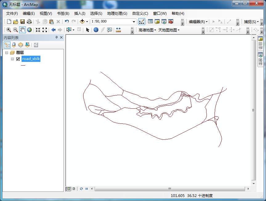
注意:所有线段连接的地方都需要断开,这样便于以后的分析。
三、数据处理
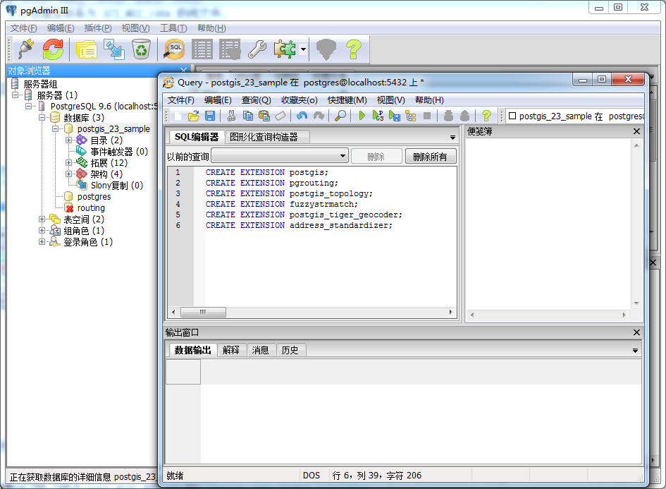
使用paAdmin3连接PostgreSQL,并执行以下语句,在新的空间数据库里添加空间扩展:
CREATE EXTENSION postgis;
CREATE EXTENSION pgrouting;
CREATE EXTENSION postgis_topology;
CREATE EXTENSION fuzzystrmatch;
CREATE EXTENSION postgis_tiger_geocoder;
CREATE EXTENSION address_standardizer;
制作完路网数据后,需要使用 来把路网数据导入到PostgreSQL中去。

点击“View connection details....”在弹出的窗口中填入PostgreSQL的账号和密码,以及Database。
连接成功后,需要设置一下“Optionns...”
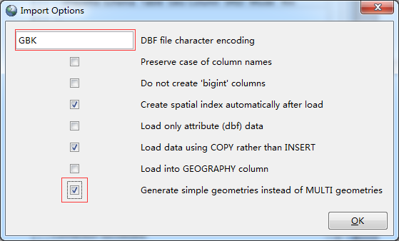
需要使用GBK编码,并勾选最下面一个选项。
添加路网数据,并设置SRID为:4326

导入完成后,会在数据库中创建一个对应的表:

在查询表中分别执行下列SQL,对表结构进行修改:
1.修改表结构
--添加起点id
ALTER TABLE public.road_xblk ADD COLUMN source integer;
--添加终点id
ALTER TABLE public.road_xblk ADD COLUMN target integer;
--添加道路权重值
ALTER TABLE public.road_xblk ADD COLUMN length double precis
2.创建拓扑结构
--为sampledata表创建拓扑布局,即为source和target字段赋值
SELECT pgr_createTopology('public.road_xblk',0.0001, 'geom', 'gid');
3.创建索引
--为source和target字段创建索引
CREATE INDEX source_idx ON road_xblk("source");
CREATE INDEX target_idx ON road_xblk("target");
4.给长度赋值
--为length赋值
update road_xblk set length =st_length(geom);
--为road_xblk表添加reverse_cost字段并用length的值赋值
ALTER TABLE road_xblk ADD COLUMN reverse_cost double precision;
UPDATE road_xblk SET reverse_cost =length;
5.创建最短路径函数
---创建查询随意两点之前的最短路径的函数
  1 DROP FUNCTION pgr_fromAtoB(tbl varchar,startx float, starty float,endx float,endy float);
  2
  3 CREATE OR REPLACE function pgr_fromAtoB(tbl varchar,startx float, starty float,endx float,endy float)
  4
  5 returns geometry as
  6
  7 $body$
  8
  9 declare
 10
 11     v_startLine geometry;--离起点最近的线
 12
 13     v_endLine geometry;--离终点最近的线
 14
 15
 16
 17     v_startTarget integer;--距离起点最近线的终点
 18
 19     v_startSource integer;
 20
 21     v_endSource integer;--距离终点最近线的起点
 22
 23     v_endTarget integer;
 24
 25
 26
 27     v_statpoint geometry;--在v_startLine上距离起点最近的点
 28
 29     v_endpoint geometry;--在v_endLine上距离终点最近的点
 30
 31
 32
 33     v_res geometry;--最短路径分析结果
 34
 35     v_res_a geometry;
 36
 37     v_res_b geometry;
 38
 39     v_res_c geometry;
 40
 41     v_res_d geometry;
 42
 43
 44
 45     v_perStart float;--v_statpoint在v_res上的百分比
 46
 47     v_perEnd float;--v_endpoint在v_res上的百分比
 48
 49
 50
 51     v_shPath_se geometry;--开始到结束
 52
 53     v_shPath_es geometry;--结束到开始
 54
 55     v_shPath geometry;--最终结果
 56
 57     tempnode float;
 58
 59 begin
 60
 61     --查询离起点最近的线
 62
 63     execute 'select geom, source, target  from ' ||tbl||
 64
 65                             ' where ST_DWithin(geom,ST_Geometryfromtext(''point('||         startx ||' ' || starty||')'',4326),15)
 66
 67                             order by ST_Distance(geom,ST_GeometryFromText(''point('|| startx ||' '|| starty ||')'',4326))  limit 1'
 68
 69                             into v_startLine, v_startSource ,v_startTarget;
 70
 71
 72
 73     --查询离终点最近的线
 74
 75     execute 'select geom, source, target from ' ||tbl||
 76
 77                             ' where ST_DWithin(geom,ST_Geometryfromtext(''point('|| endx || ' ' || endy ||')'',4326),15)
 78
 79                             order by ST_Distance(geom,ST_GeometryFromText(''point('|| endx ||' ' || endy ||')'',4326))  limit 1'
 80
 81                             into v_endLine, v_endSource,v_endTarget;
 82
 83
 84
 85     --如果没找到最近的线,就返回null
 86
 87     if (v_startLine is null) or (v_endLine is null) then
 88
 89         return null;
 90
 91     end if ;
 92
 93
 94
 95     select  ST_ClosestPoint(v_startLine, ST_Geometryfromtext('point('|| startx ||' ' || starty ||')',4326)) into v_statpoint;
 96
 97     select  ST_ClosestPoint(v_endLine, ST_GeometryFromText('point('|| endx ||' ' || endy ||')',4326)) into v_endpoint;
 98
 99
100
101    -- ST_Distance
102
103
104
105     --从开始的起点到结束的起点最短路径
106
107     execute 'SELECT st_linemerge(st_union(b.geom)) ' ||
108
109     'FROM pgr_kdijkstraPath(
110
111     ''SELECT gid as id, source, target, length as cost FROM ' || tbl ||''','
112
113     ||v_startSource || ', ' ||'array['||v_endSource||'] , false, false
114
115     ) a, '
116
117     || tbl || ' b
118
119     WHERE a.id3=b.gid
120
121     GROUP by id1
122
123     ORDER by id1' into v_res ;
124
125
126
127     --从开始的终点到结束的起点最短路径
128
129     execute 'SELECT st_linemerge(st_union(b.geom)) ' ||
130
131     'FROM pgr_kdijkstraPath(
132
133     ''SELECT gid as id, source, target, length as cost FROM ' || tbl ||''','
134
135     ||v_startTarget || ', ' ||'array['||v_endSource||'] , false, false
136
137     ) a, '
138
139     || tbl || ' b
140
141     WHERE a.id3=b.gid
142
143     GROUP by id1
144
145     ORDER by id1' into v_res_b ;
146
147
148
149     --从开始的起点到结束的终点最短路径
150
151     execute 'SELECT st_linemerge(st_union(b.geom)) ' ||
152
153     'FROM pgr_kdijkstraPath(
154
155     ''SELECT gid as id, source, target, length as cost FROM ' || tbl ||''','
156
157     ||v_startSource || ', ' ||'array['||v_endTarget||'] , false, false
158
159     ) a, '
160
161     || tbl || ' b
162
163     WHERE a.id3=b.gid
164
165     GROUP by id1
166
167     ORDER by id1' into v_res_c ;
168
169
170
171     --从开始的终点到结束的终点最短路径
172
173     execute 'SELECT st_linemerge(st_union(b.geom)) ' ||
174
175     'FROM pgr_kdijkstraPath(
176
177     ''SELECT gid as id, source, target, length as cost FROM ' || tbl ||''','
178
179     ||v_startTarget || ', ' ||'array['||v_endTarget||'] , false, false
180
181     ) a, '
182
183     || tbl || ' b
184
185     WHERE a.id3=b.gid
186
187     GROUP by id1
188
189     ORDER by id1' into v_res_d ;
190
191
192
193     if(ST_Length(v_res) > ST_Length(v_res_b)) then
194
195        v_res = v_res_b;
196
197     end if;
198
199
200
201     if(ST_Length(v_res) > ST_Length(v_res_c)) then
202
203        v_res = v_res_c;
204
205     end if;
206
207
208
209     if(ST_Length(v_res) > ST_Length(v_res_d)) then
210
211        v_res = v_res_d;
212
213     end if;
214
215
216
217
218
219     --如果找不到最短路径,就返回null
220
221     --if(v_res is null) then
222
223     --    return null;
224
225     --end if;
226
227
228
229     --将v_res,v_startLine,v_endLine进行拼接
230
231     select  st_linemerge(ST_Union(array[v_res,v_startLine,v_endLine])) into v_res;
232
233
234
235     select  ST_Line_Locate_Point(v_res, v_statpoint) into v_perStart;
236
237     select  ST_Line_Locate_Point(v_res, v_endpoint) into v_perEnd;
238
239
240
241     if(v_perStart > v_perEnd) then
242
243         tempnode =  v_perStart;
244
245         v_perStart = v_perEnd;
246
247         v_perEnd = tempnode;
248
249     end if;
250
251
252
253     --截取v_res
254
255     SELECT ST_Line_SubString(v_res,v_perStart, v_perEnd) into v_shPath;
256
257
258
259     return v_shPath;
260
261
262
263 end;
264
265 $body$
266
267 LANGUAGE plpgsql VOLATILE STRICT;
四、数据发布
数据准备完成后,就需要用GeoServer来进行发布:
启动GeoServer,在浏览器中输入,http://localhost:8080/geoserver/web/,登录到GeoServer。
1.创建工作区
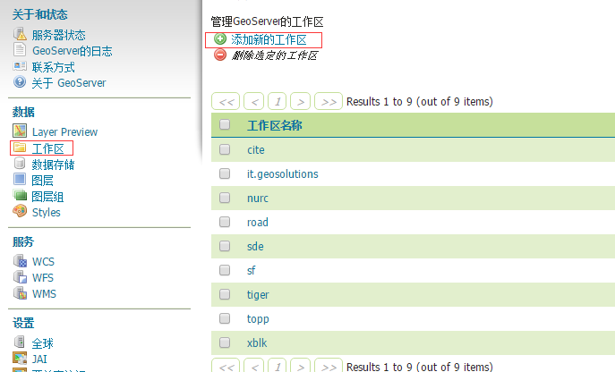
添加xblk名称的工作区。
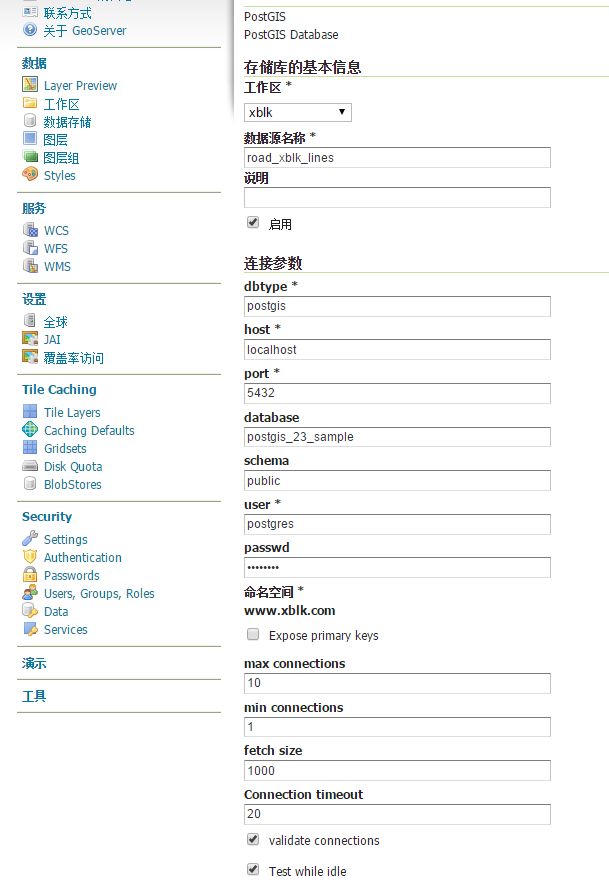
2.添加数据存储:

填入对应的连接信息:
3.添加图层:
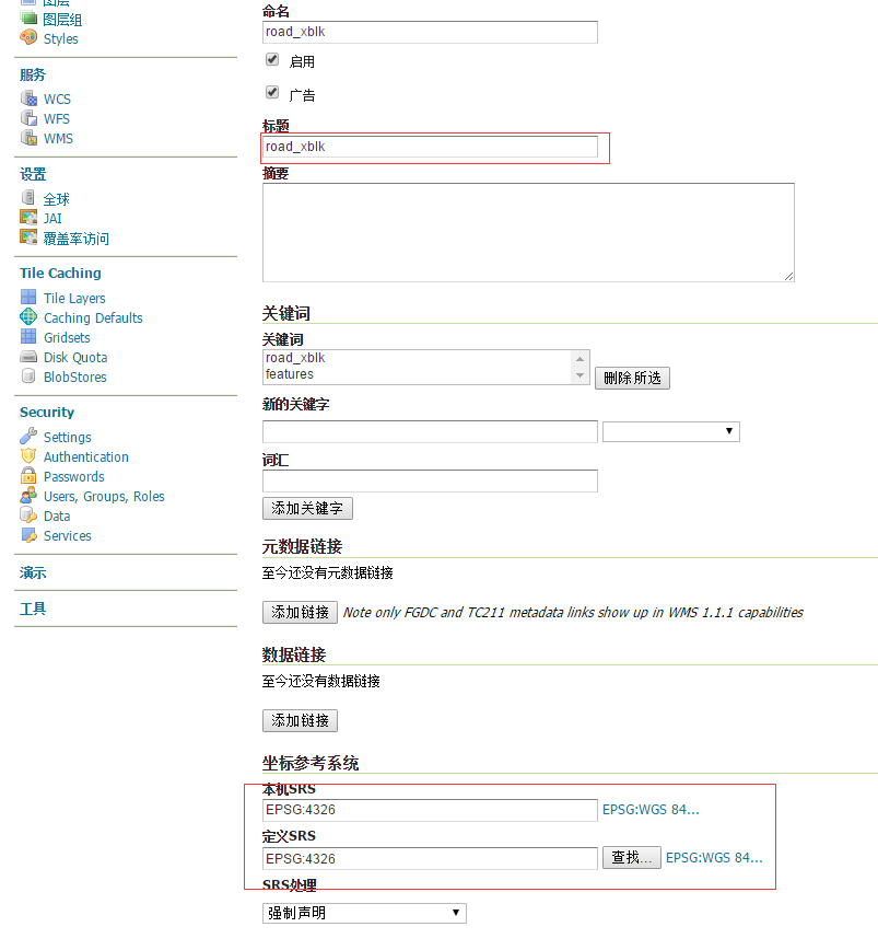
注意红框中的内容。
4.添加路径查询服务,添加图层,选择“配置新的SQL视图”:

视图名称:navigation
SQL语句:
SELECT * FROM pgr_fromAtoB('road_xblk', %x1%, %y1%, %x2%, %y2%)
验证的正则表达式:^-?[\d.]+$
类型:LingString
SRID:4326
点击保存后,填入SRS,并自动计算范围:

五、结果展示
使用OpenLayer进行结果展示,代码请直接下载,结果如下:

说明:这个最短路径的算法有一定的问题,在特定的条件下,查找的不一定是最短的路径,需要对数据进行再处理,或者对算法进行优化。
作者:LionGIS
邮箱:liongis@163.com
QQ:1366940902
出处:http://liongis.cnblogs.com/
欢迎转载,请在文章页面明显位置给出原文链接。

 浙公网安备 33010602011771号