
Get A Transportation Network From OSMFile
# Obtain a transportation network from an osm file.
# get osm file 方式1:OpenStreetMap Homepage
# .osm.pbf下载地址 方式2:http://download.openstreetmap.fr/extracts/asia/china/
# get osm file 方式3:Geofabrik https://download.geofabrik.de/
# get osm file 方式4: BBBike(可支持多边形范围) https://extract.bbbike.org/
import osm2gmns as og
import osm2gmns.settings as defaultsettings
# pip install -i http://mirrors.aliyun.com/pypi/simple/ osm2gmns --trusted-host mirrors.aliyun.com
# FromOSMFile
# net = og.getNetFromOSMFile(r'D:/DataWorkspace/data/beijing.osm',
# network_type=('auto',), link_type='all',
# POIs=False, POI_sampling_ratio=1.0,
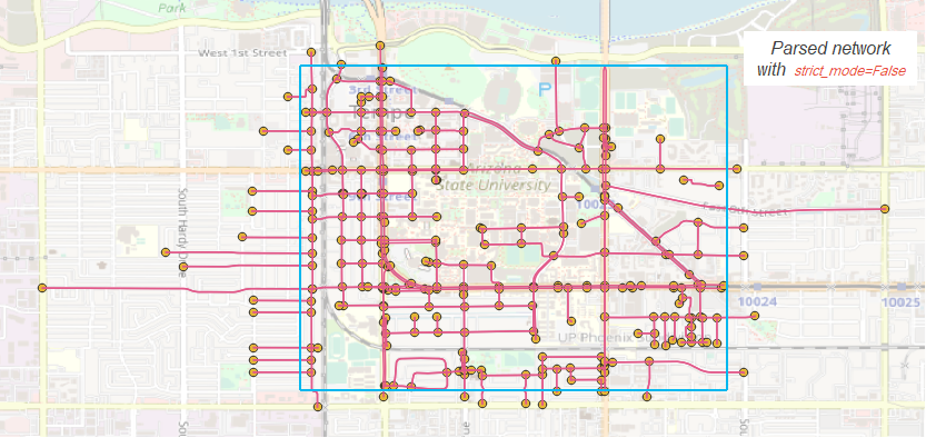
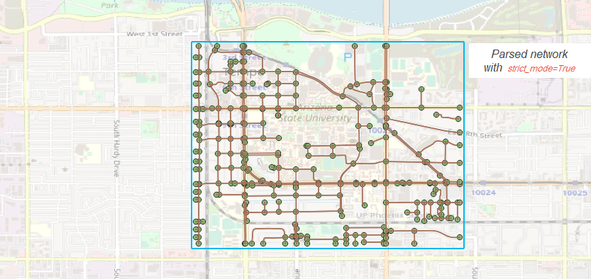
# strict_mode=True,
# offset='no',
# min_nodes=1,
# combine=False,
# int_buffer=defaultsettings.default_int_buffer,
# bbox=None,
# default_lanes=False,
# default_speed=False)
# FromPBFFile
net = og.getNetFromPBFFile(r'D:/DataWorkspace/data/beijing.osm.pbf',
network_type=('auto',), link_type='all',
POIs=False, POI_sampling_ratio=1.0,
strict_mode=True,
offset='no',
min_nodes=1,
combine=False,
int_buffer=defaultsettings.default_int_buffer,
bbox=None,
default_lanes=False,
default_speed=False)
# Recommend using getNetFromPBFFile() for large networks
# net = og.getNetFromPBFFile('***.osm.pbf')
default_lanes_dict = {'motorway': 4, 'trunk': 3, 'primary': 3, 'secondary': 2, 'tertiary': 2,
'residential': 1, 'service': 1, 'cycleway':1, 'footway':1, 'track':1,
'unclassified': 1, 'connector': 2}
default_speed_dict = {'motorway': 59, 'trunk': 39, 'primary': 39, 'secondary': 39, 'tertiary': 29,
'residential': 29, 'service': 29, 'cycleway':9, 'footway':4, 'track':29,
'unclassified': 29, 'connector':59}
# 保存成CSV Output Networks to CSV
og.outputNetToCSV(net, output_folder='netcsv', projection=False, enconding=None)
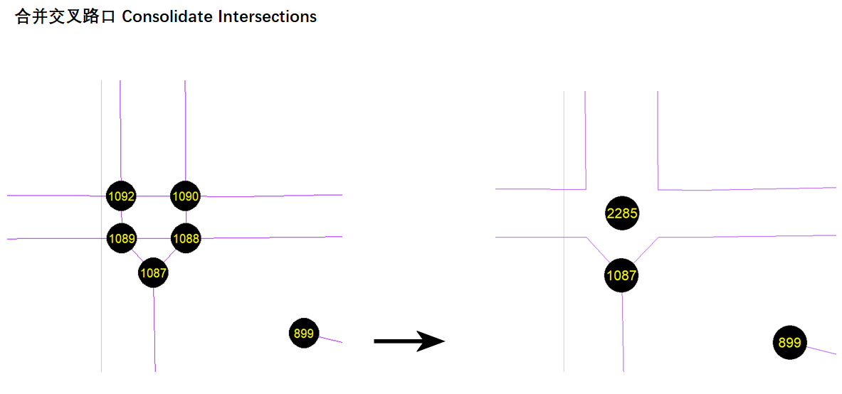
# 合并交叉路口 Consolidate Intersections
og.consolidateComplexIntersections(net)
og.outputNetToCSV(net, output_folder='netcsv_csd', projection=False, enconding=None)
# # 也可以先保存成csv,然后人工编辑,最后再合并
# net = og.getNetFromPBFFile(r'D:/DataWorkspace/data/beijing.osm.pbf')
# og.outputNetToCSV(net, output_folder='', projection=False, enconding=None)
# # check the main_node_id column in node.csv
# net = og.getNetFromCSV(folder='', enconding=None)
# og.consolidateComplexIntersections(net)
# og.outputNetToCSV(net, output_folder='consolidated', projection=False, enconding=None)
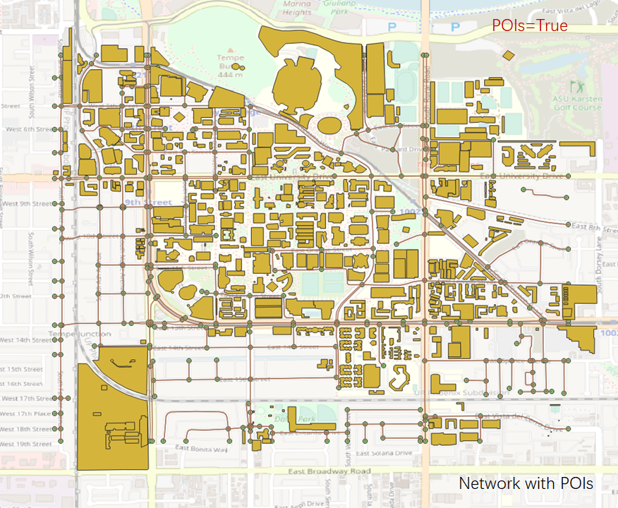
# # 连接POI
# # Network with POIs
# net = og.getNetFromPBFFile(r'D:/DataWorkspace/data/beijing.osm.pbf',
# network_type=('auto',), link_type='all',
# POIs=True, POI_sampling_ratio=1.0,
# strict_mode=True,
# offset='no',
# min_nodes=1,
# combine=False,
# int_buffer=defaultsettings.default_int_buffer,
# bbox=None,
# default_lanes=False,
# default_speed=False)
# # Connect POIs with network
# og.connectPOIWithNet(net)
# Visualization
# You can visualize generated networks using NeXTA or QGis.
# NeXTA:https://github.com/xzhou99/NeXTA-GMNS OR https://github.com/asu-trans-ai-lab/DTALite
贴几张图吧 记录而已

个人学习记录

 浙公网安备 33010602011771号