
Harmonized Landsat Sentinel-2 (HLS) 数据介绍
HLS数据介绍
https://hls.gsfc.nasa.gov/
https://lpdaac.usgs.gov/data/get-started-data/collection-overview/missions/harmonized-landsat-sentinel-2-hls-overview/
Harmonized Landsat Sentinel-2 (HLS) 是 NASA 的一项举措,输入产品是 Landsat 8-9 L1 和 Sentinel-2 L1C 大气层顶部反射率。该数据自2013年4月起在全球范围内提供,分辨率为30米,重访时间为2-3天。
它被广泛用于监测植被、土地利用和土地覆盖随时间的变化。
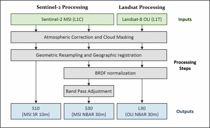
HLS 产品由一组算法创建:大气校正、云和云阴影遮罩、地理联合配准和通用网格、双向反射率分布函数归一化和带通调整。 HLS 2.0 版数据现已提供,覆盖全球(南极洲除外)。 目前,HLS 在这个虚拟星座中有四个传感器,每三天在赤道提供一次观测,并且随着纬度的增加,观测频率会更高。 HLS 项目是 NASA 和 USGS 之间的合作项目,NASA 戈达德太空飞行中心的科学团队得到了 USGS 地球资源观测和科学 (EROS) 大气校正中心的支持,NASA 马歇尔太空飞行中心的制作团队以及产品档案 在美国地质勘探局。
The Harmonized Landsat and Sentinel-2 (HLS) project is a NASA initiative aiming to produce a seamless surface reflectance record from the Operational Land Imager (OLI) and Multi-Spectral Instrument (MSI) aboard Landsat-8/9 and Sentinel-2A/B remote sensing satellites, respectively. The HLS products are created from a set of algorithms: atmospheric correction, cloud and cloud-shadow masking, geographic co-registration and common gridding, bidirectional reflectance distribution function normalization, and bandpass adjustment.
The HLS Version-2.0 data are available now with a global coverage (except for Antarctica). With four sensors in this virtual constellation currently, HLS provides observations once every three days at the equator and more frequently with increasing latitude.
The HLS project is a collaboration between NASA and USGS, with the science team at NASA Goddard Space Flight Center supported by USGS Earth Resources Observation and Science (EROS) Center on atmospheric correction, the production team at NASA Marshall Space Flight Center, and product archive at USGS. Harmonized Landsat Sentinel (HLS) is an initiative of NASA to create a Virtual Constellation of surface reflectance data (SR) from the Operational Land Imager (OLI) and the Multi-Spectral Instrument (MSI) onboard the remote sensing satellites Landsat 8-9 and Sentinel-2. The input products are Landsat 8-9 L1 and Sentinel-2 L1C top-of-atmosphere reflectance. The data has been available globally since April 2013, has a resolution of 30 meters and a revisit time of 2-3 days.
HLS处理教程 提取EVI时间序列
https://lpdaac.usgs.gov/resources/e-learning/getting-started-cloud-native-hls-data-python/

 浙公网安备 33010602011771号