贪心 + 计算几何 --- Radar Installation
Radar Installation
Description
Assume the coasting is an infinite straight line. Land is in one side of coasting, sea in the other. Each small island is a point locating in the sea side. And any radar installation, locating on the coasting, can only cover d distance, so an island in the sea can be covered by a radius installation, if the distance between them is at most d.
We use Cartesian coordinate system, defining the coasting is the x-axis. The sea side is above x-axis, and the land side below. Given the position of each island in the sea, and given the distance of the coverage of the radar installation, your task is to write a program to find the minimal number of radar installations to cover all the islands. Note that the position of an island is represented by its x-y coordinates.
We use Cartesian coordinate system, defining the coasting is the x-axis. The sea side is above x-axis, and the land side below. Given the position of each island in the sea, and given the distance of the coverage of the radar installation, your task is to write a program to find the minimal number of radar installations to cover all the islands. Note that the position of an island is represented by its x-y coordinates.
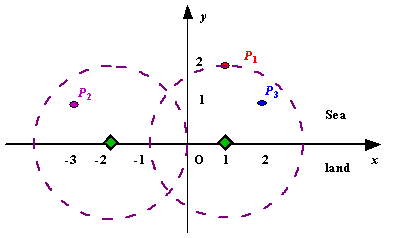
 Figure A Sample Input of Radar Installations
Input
The
input consists of several test cases. The first line of each case
contains two integers n (1<=n<=1000) and d, where n is the number
of islands in the sea and d is the distance of coverage of the radar
installation. This is followed by n lines each containing two integers
representing the coordinate of the position of each island. Then a blank
line follows to separate the cases.
The input is terminated by a line containing pair of zeros
The input is terminated by a line containing pair of zeros
Output
For
each test case output one line consisting of the test case number
followed by the minimal number of radar installations needed. "-1"
installation means no solution for that case.
Sample Input
3 2
1 2
-3 1
2 1

1 2
0 2

0 0
Sample Output
Case 1: 2
Case 2: 1
题目来源
http://poj.org/problem?id=1328
解题思路
以每个岛的坐标为圆心画圆,会与x轴有2个交点,那么这2个点就是能覆盖该岛的雷达x 坐标区间,问题就转变成对一组区间,找最少数目的点,使得所有区间中都有一点。把包含某区间的区间删掉(如果一个点使得子区间得到满足, 那么该区间也将得到满足),这样所有区间的终止位置严格递增。
每次迭代对于第一个区间, 选择最右边一个点, 因为它可以让较多区间得到满足, 如果不选择第一个区间最右一个点(选择前面的点), 那么把它换成最右的点之后, 以前得到满足的区间, 现在仍然得到满足, 所以第一个区间的最右一个点为贪婪选择, 选择该点之后, 将得到满足的区间删掉, 进行下一步迭代, 直到结束。
代码:
#include <algorithm>
#include <cmath>
#include <cstdio>
#include <iostream>

using namespace std;

#define MAX 1010

struct Point {
  float x, y;
  float l, r;
  bool marked;
};

Point points[MAX];

bool cmp(Point a, Point b) { return a.r < b.r; }
int main() {
  int case_cnt = 1;
  int n;
  float r;
  while (cin >> n >> r) {
    if (n == 0 && r == 0) {
      break;
    }

    int i, j;
    int cnt = 0;
    if (r <= 0)
      cnt = -1;

    for (i = 0; i < n; i++) {
      scanf("%f%f", &points[i].x, &points[i].y); // 血的教训,cout会超时
      if (points[i].y > r)
        cnt = -1;
      points[i].l = points[i].x - sqrt(r * r - points[i].y * points[i].y);
      points[i].r = points[i].x + sqrt(r * r - points[i].y * points[i].y);
    }
    printf("Case %d: ", case_cnt++);
    if (cnt == -1) {
      cout << "-1" << endl;
      continue;
    }
    for (i = 0; i < n; i++)
      points[i].marked = false;
    sort(points, points + n, cmp);
    bool covered = false;
    for (i = 0; i < n && cnt >= 0; i++) {
      if (points[i].marked) {
        continue;
      }
      for (j = 0; j < n; j++) {
        if (points[j].marked) {
          continue;
        }
        if (points[j].l <= points[i].r) {
          points[j].marked = true;
          covered = true;
        } else {
          break;
        }
      }
      if (covered)
        cnt++;
      covered = false;
    }
    cout << cnt << endl;
  }
  return 0;
}

 浙公网安备 33010602011771号