

Note_ Can Semantic Labeling Methods Generalize to Any City The Inria Aerial Image Labeling Benchmark
基本信息
2017 IGARSS (顶会)
Can Semantic Labeling Methods Generalize to Any City? The Inria Aerial Image Labeling Benchmark
笔记
作者的认为现在遥感领域的算法受限于数据集。
-
数据集所涵盖的面积比较小,遥感数据和地点关系比较大,所以算法的泛化能力也受到了数据集的限制。
those images cover limited geographic areas and the evaluation procedure does not assess how the methods generalize to different contexts or more abstract semantic classes.
> the image tiles tend to be self-similar and with uniform color histograms
所以,提出一个开放的数据集合:
Dataset features:
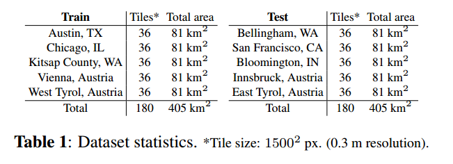
- Coverage of 810 km² (405 km² for training and 405 km² for testing)
- Aerial orthorectified color imagery with a spatial resolution of 0.3 m
- Ground truth data for two semantic classes: building and not building (publicly disclosed only for the training subset)
具体如下:
同时开放一个检测平台contest,提供测试集的测试服务,也是一个比赛。
作者的另一个贡献是,自己做了实验,定了一个baseline,
实验
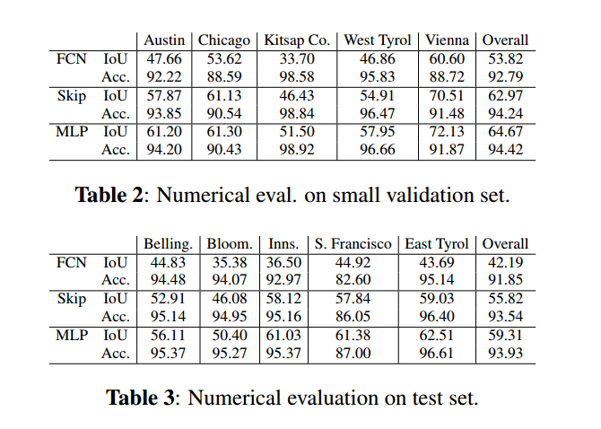
第一步,将训练集合分成训练集合和验证集合,也就是small vallidation set。
先是做了base-FCN的实验,然后参考论文(Emmanuel Maggiori, Yuliya Tarabalka, Guillaume Charpiat, and Pierre Alliez, “High-resolution semantic labeling with convolutional neural networks,” arXiv preprint arXiv:1611.01962, 2016. )结合各层特征,做了Skip 的实验。自己再修正,重点介绍了关于MLP的实验。
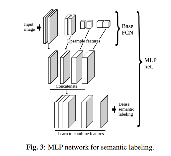
主要的改进是Concatenate各个特征层,然后,利用一个只有一个hidden层MLP来,实现分类。
总结
整个测试,注重两个指标:
- First, the accuracy,defined as the percentage of correctly classified pixels.
- Secondly, the intersection over union (IoU) of the positive (building) class.
关于IOU的提升空间还很大~
The MLP network reaches about 60% IoU on the entire test set. This means that the output objects overlap the real ones by 60%, as assessed over a significant amount of test data. While there is certainly room for improvement·····

 浙公网安备 33010602011771号