OpenLayers学习笔记(十)— 动态加载JSON数据模拟航迹线
在openlayers 3 上,加载本地json数据,动态绘制航迹线,以飞机当前位置为地图中心,此例子是模拟DEMO
本文链接:动态加载JSON数据模拟航迹线
作者:狐狸家的鱼
GitHub:八至

前提需求
需要以JSON数据动态加载绘制飞机轨迹线,飞机图标以加载的坐标为当前实时位置,经过的坐标追加到轨迹线上,标牌始终跟随飞机移动。
简单搭建本地服务器
因为要加载本地JSON文件,可能会存在跨域问题,所以在本地搭建一个服务器来加载数据,会更加方便。
1.全局安装http-server
npm install http-server -g
右键菜单添加cmd窗口
这是题外话,只是为了打开方便,在右键菜单中加入”在此处打开命令窗口“
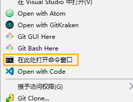
参考这个,步骤:
- 随便在哪里新建一个txt文件,命名为OpenCmdHere.txt
- 在文件中输入如下代码,并保存
- 更改文件后缀名为reg,弹出的提示点确认
- 双击OpenCmdHere.reg文件运行,弹出的提示点确认,修改注册表就大功告成了
Windows Registry Editor Version 5.00

[HKEY_CLASSES_ROOT\Directory\shell\OpenCmdHere]
@="在此处打开命令窗口"
"Icon"="cmd.exe"

[HKEY_CLASSES_ROOT\Directory\shell\OpenCmdHere\command]
@="cmd.exe /s /k pushd "%V""

[HKEY_CLASSES_ROOT\Directory\Background\shell\OpenCmdHere]
@="在此处打开命令窗口"
"Icon"="cmd.exe"

[HKEY_CLASSES_ROOT\Directory\Background\shell\OpenCmdHere\command]
@="cmd.exe /s /k pushd \"%V\""

[HKEY_CLASSES_ROOT\Drive\shell\OpenCmdHere]
@="在此处打开命令窗口"
"Icon"="cmd.exe"

[HKEY_CLASSES_ROOT\Drive\shell\OpenCmdHere\command]
@="cmd.exe /s /k pushd \"%V\""

[HKEY_CLASSES_ROOT\LibraryFolder\background\shell\OpenCmdHere]
@="在此处打开命令窗口"
"Icon"="cmd.exe"

[HKEY_CLASSES_ROOT\LibraryFolder\background\shell\OpenCmdHere\command]
@="cmd.exe /s /k pushd \"%V\""
启动服务器
进入map文件夹,右键打开cmd窗口,输入命令:
http-server
就像这样:
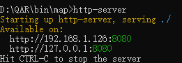
服务器就启动了,文件夹里的所有数据都可以加载了。在浏览器里输入http://192.168.1.126:8080或者http://127.0.0.1:8080都可以加载。
效果实现
1.初始化地图和图层
(1)图层以及样式
/**
         * @name: 相关样式和图层:点 航迹线 飞机  标牌
         * @msg:
         * @param {type}
         * @return:
         */
        //样式
        let route_style = new ol.style.Style({
            stroke:new ol.style.Stroke({
                width:2,
                color: '#007cbf'
            }),
            zIndex:2
        });
        //创建轨迹线
        let trackLine = new ol.geom.LineString([]);
        //矢量图层层
        let aircfaftLayer = new ol.layer.Vector({
            source:new ol.source.Vector(),
        })
        let flightTrackLayer = new ol.layer.Vector({
            source:new ol.source.Vector({
                features:[
                    new ol.Feature({
                        geometry:trackLine
                    })
                ]
            }),
            style:route_style,
            updateWhileInteracting: true,//拖拽时自动更新位置 顺滑拖拽
        });
       /*
         * @name: 初始化地图
         * @description:
         * @param {type} none
         * @return:

        */
       const center = new ol.proj.fromLonLat([104.06250000000001, 30.65681556429287]);
        //地图
        let map = new ol.Map({
            //图层顺序自下而上
            layers: [
                new ol.layer.Tile({
                    source: new ol.source.OSM({ })
                }),flightTrackLayer,aircfaftLayer,
            ],
            renderer: 'canvas',
            target: 'map',
            view: new ol.View({
                center: center,
                zoom: 6
            })
        });
(2)创建元素(图标、标注信息叠加层)
 /**
         * @name: 飞机 标牌 航迹
         * @description:
         * @param {type} none
         * @return:
         */
        //标牌叠加层
        let markerEl = document.getElementById('geo-marker');
        let marker = new ol.Overlay({
            positioning: 'bottom-center',
            stopEvent: false,
            dragging: false,
            offset: [0, 0],
            element: markerEl,
            stopEvent: false
        });
        map.addOverlay(marker);

        //飞机图标样式
        function createGoodStyle(aircraftNum) {
            return new ol.style.Style({
                image:new ol.style.Circle({
                    radius:4,
                    snapToPixel:false,
                    fill:new ol.style.Fill({
                        color:'yellow'
                    }),
                    stroke:new ol.style.Stroke({
                        color:"#333",
                        width:2
                    })
                })
            });
        }

        //设置地图中心
        let centerAir = val => {
            map.getView().setCenter(val);
        }
(3)动态加载数据
 /**
         * @name: 加载数据
         * @description:
         * @param {type} none
         * @return:
         */
        //添加飞机 + 更新位置
        let coords, intervalId, interval = 1000, i = 0;
        const url = './data/flight.json';
        let theAirplane = new ol.Feature([]);
        $('.startAnimate').click(() => {
            //加载坐标数据
            $.ajax({
                url: url,
                dataType: 'json',
                success: function (response) {
                    console.log(response);
                    coords = response.coordinates;
                    label = response.aircraftNum;
                    // 飞机
                    let position = ol.proj.fromLonLat(coords[0]);
                    //飞机
                    theAirplane.setId(response.aircraftNum);
                    theAirplane.set("speed", response.speed);
                    theAirplane.setStyle(createGoodStyle(response.aircraftNum));
                    theAirplane.getStyle().getImage().setRotation(response.rotation);
                    aircfaftLayer.getSource().addFeature(theAirplane);
                    //航迹线和标牌
                    intervalId = setInterval(() => {
                        position = ol.proj.fromLonLat(coords[i]);
                        //标牌
                        marker.setPosition(position);
                        markerEl.innerHTML = response.aircraftNum;//简标牌//航迹
                        let point = new ol.proj.transform(coords[i], 'EPSG:4326', 'EPSG:3857');
                        trackLine.appendCoordinate(point);
                        //以当前位置为地图中心
                        centerAir(position);
                        i++;
                        if(i === coords.length) {
                            clearInterval(intervalId);//停止循环
                        }
                    }, interval);
                }
            })
        })
(4)json数据
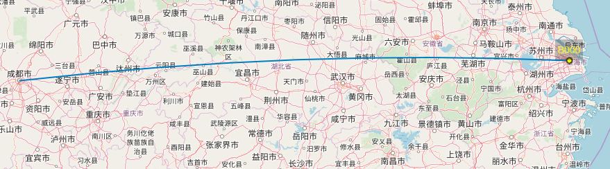
json数据来源于arc.js,该例子选取的是成都—上海的坐标数据:
{

    "ID":"1",
    "aircraftNum": "B000",
    "speed":"25",
    "rotation":"114",
    "coordinates": [
        [104.06250000000001, 30.65681556429287],
        [104.23659653944907, 30.67396833485058],
        [104.4107544999246, 30.690888911014596],
        [104.58497310591778, 30.70757705503652],
        [104.75925157857333, 30.724032532190993],
        [104.93358913572729, 30.740255110788784],
        [105.10798499194534, 30.75624456218971],
        [105.28243835856125, 30.772000660815337],
        [105.45694844371592, 30.787523184161603],
        [105.63151445239656, 30.80281191281125],
        [105.80613558647657, 30.817866630446186],
        [105.98081104475536, 30.8326871238596],
        [106.15554002299895, 30.847273182967992],
        [106.33032171398055, 30.861624600823],
        [106.50515530752187, 30.875741173623137],
        [106.68003999053437, 30.889622700725297],
        [106.85497494706121, 30.90326898465615],
        [107.02995935831927, 30.916679831123393],
        [107.20499240274177, 30.929855049026738],
        [107.38007325602092, 30.942794450468945],
        [107.55520109115115, 30.95549785076639],
        [107.73037507847249, 30.967965068459744],
        [107.90559438571445, 30.98019592532436],
        [108.08085817803996, 30.992190246380456],
        [108.25616561808987, 31.003947859903253],
        [108.43151586602752, 31.01546859743276],
        [108.60690807958395, 31.026752293783623],
        [108.7823414141029, 31.0377987870545],
        [108.9578150225866, 31.0486079186376],
        [109.13332805574153, 31.059179533227734],
        [109.30887966202457, 31.069513478831404],
        [109.48446898768944, 31.079609606775563],
        [109.66009517683327, 31.089467771716325],
        [109.83575737144373, 31.099087831647413],
        [110.011454711446, 31.108469647908397],
        [110.18718633475038, 31.11761308519283],
        [110.36295137729994, 31.126518011556165],
        [110.53874897311843, 31.135184298423425],
        [110.7145782543585, 31.14361182059676],
        [110.89043835135004, 31.151800456262833],
        [111.06632839264884, 31.1597500869999],
        [111.24224750508553, 31.16746059778481],
        [111.4181948138144, 31.17493187699975],
        [111.5941694423629, 31.182163816438862],
        [111.77017051268102, 31.18915631131456],
        [111.94619714519094, 31.195909260263747],
        [112.1222484588369, 31.202422565353807],
        [112.29832357113521, 31.208696132088367],
        [112.47442159822452, 31.21472986941292],
        [112.65054165491617, 31.220523689720157],
        [112.82668285474469, 31.226077508855244],
        [113.00284431001862, 31.231391246120737],
        [113.17902513187131, 31.236464824281384],
        [113.35522443031194, 31.241298169568736],
        [113.53144131427662, 31.245891211685535],
        [113.70767489167979, 31.250243883809823],
        [113.88392426946552, 31.254356122599024],
        [114.0601885536591, 31.258227868193615],
        [114.23646684941869, 31.26185906422076],
        [114.41275826108706, 31.265249657797618],
        [114.58906189224348, 31.268399599534526],
        [114.76537684575561, 31.271308843537938],
        [114.94170222383167, 31.27397734741316],
        [115.11803712807243, 31.276405072266883],
        [115.2943806595235, 31.27859198270948],
        [115.47073191872758, 31.28053804685718],
        [115.64709000577683, 31.282243236333912],
        [115.82345402036526, 31.28370752627301],
        [115.99982306184107, 31.284930895318737],
        [116.17619622925929, 31.285913325627515],
        [116.35257262143426, 31.28665480286904],
        [116.52895133699217, 31.28715531622708],
        [116.70533147442355, 31.28741485840016],
        [116.8817121321361, 31.28743342560202],
        [117.0580924085071, 31.28721101756178],
        [117.23447140193603, 31.286747637524012],
        [117.41084821089731, 31.286043292248515],
        [117.58722193399282, 31.285097992009906],
        [117.76359167000443, 31.283911750597046],
        [117.93995651794664, 31.282484585312172],
        [118.11631557711907, 31.280816516969885],
        [118.29266794715906, 31.278907569895903],
        [118.46901272809394, 31.276757771925578],
        [118.64534902039362, 31.27436715440231],
        [118.82167592502275, 31.271735752175562],
        [118.99799254349321, 31.268863603598895],
        [119.17429797791613, 31.26575075052759],
        [119.35059133105422, 31.262397238316204],
        [119.52687170637368, 31.258803115815805],
        [119.70313820809623, 31.254968435371172],
        [119.87938994125103, 31.250893252817523],
        [120.05562601172639, 31.2465776274773],
        [120.2318455263214, 31.242021622156606],
        [120.40804759279759, 31.237225303141468],
        [120.58423131993031, 31.232188740193873],
        [120.76039581756008, 31.226912006547636],
        [120.93654019664363, 31.221395178904057],
        [121.11266356930511, 31.215638337427364],
        [121.28876504888679, 31.20964156573994],
        [121.46484375, 31.203404950917395]
    ]

}
加载完成后效果如下:
后续要完成的就是以飞机当前速度和航线预测未来5分钟所在的坐标位置,以及拖拽标注信息叠加层
查看源码:GitHub

 浙公网安备 33010602011771号