GPS轨迹数据集免费下载资源整理
本文为转载文章 转载请注明出处:
https://blog.csdn.net/liangyihuai/article/details/58335510#comments
本文主要是整理了GPS轨迹数据集免费资源库,从这些库中能够免费下载到GPS数据,同时还整理出了这些数据的格式,数据集的简单描述等等。如果你发现更好的相关数据资源,欢迎共享 :)
1. GeoLife GPS Trajectories
该GPS轨迹数据集出自微软研究GeoLift项目。从2007年四月到2012年八月收集了182个用户的轨迹数据。这些数据包含了一系列以时间为序的点,每一个点包含经纬度、海拔等信息。包含了17621个轨迹,总距离120多万公里,总时间48000多小时。这些数据不仅仅记录了用户在家和在工作地点的位置轨迹,还记录了大范围的户外活动轨迹,比如购物、旅游、远足、骑自行车。
这个数据集可以用来进行用户活动相似度估算,移动模型挖掘,用户活动推荐,基于位置的社交网络,位置隐私,位置推荐。
时间:2007年4月~2012年8月
数据大小:大概300M.
下载地址:https://www.microsoft.com/en-us/download/details.aspx?id=52367
数据格式:
一个文件夹存储一个用户的GPS日志,这些日志文件都被转换成了plt格式。为了避免时间区间问题,统一使用了GMT格式的时间表示。其他具体格式为:
Line 1…6 are useless in this dataset, andcan be ignored. Points are described in following lines, one for each line.
Field 1: Latitude in decimal degrees.
Field 2: Longitude in decimal degrees.
Field 3: All set to 0 for this dataset.
Field 4: Altitude in feet (-777 if notvalid).
Field 5: Date - number of days (withfractional part) that have passed since 12/30/1899.
Field 6: Date as a string.
Field 7: Time as a string.
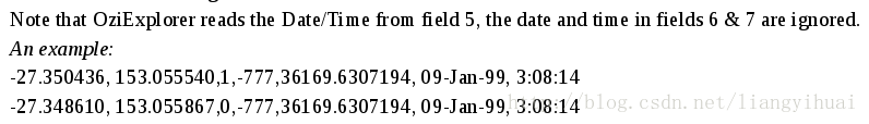
Note that field 5 and field 6&7represent the same date/time in this dataset. You may use either of them.
Example:
39.906631,116.385564,0,492,40097.5864583333,2009-10-11,14:04:30
39.906554,116.385625,0,492,40097.5865162037,2009-10-11,14:04:35- 1
- 2
- 3
- 4
- 5
- 6
- 7
- 8
- 9
- 10
- 11
- 12
- 13
交通方式数据集格式:
可能的交通方式有:walk,bike, bus, car, subway, train, airplane, boat, run and motorcycle,再次强调,虽然大多数数据是在中国产生的,但是,还是把时间或者日期都统一以GMT的时间形式表示。
例如:
Start Time End Time Transportation Mode
2008/04/02 11:24:21 2008/04/02 11:50:45bus
具体说明在下载的文件压缩包中!
- 使用到该数据的论文有:
Q. Li, Y. Zheng, X. Xie, Y. Chen, W. Liu, and M. Ma. 2008.Mining user similarity based on location history. In Proceedings of the 16thAnnual ACM International Conference on Advances in Geographic InformationSystems. ACM, 34.
Z. Chen, H. T. Shen, X. Zhou, Y. Zheng, and X. Xie. 2010.Searching trajectories by locations—An efficient study. In Proceedings of the29th ACM SIGMOD International Conference on Management of Data. ACM,255–266.
[1] Yu Zheng, Lizhu Zhang, Xing Xie, Wei-Ying Ma. Mininginteresting locations and travel sequences from GPS trajectories. InProceedings of International conference on World Wild Web (WWW 2009), MadridSpain. ACM Press: 791-800.
[2] Yu Zheng, Quannan Li, Yukun Chen, Xing Xie, Wei-Ying Ma.Understanding Mobility Based on GPS Data. In Proceedings of ACM conference onUbiquitous Computing (UbiComp 2008), Seoul, Korea. ACM Press: 312-321.
[3] Yu Zheng, Xing Xie, Wei-Ying Ma, GeoLife: ACollaborative Social Networking Service among User, location and trajectory.Invited paper, in IEEE Data Engineering Bulletin. 33, 2, 2010, pp. 32-40.
2.T-Drive Taxi Trajectories
这个数据来自微软T-Drive项目,包含在2008年北京一万多俩出租车一周的轨迹数据。这个数据集包含了1500万个坐标点,轨迹的总距离达到900多万公里。
时间:2008年
数据大小:80M左右。
- 数据集下载地址:
https://www.microsoft.com/en-us/research/publication/t-drive-trajectory-data-sample/
- 数据详细说明:
https://www.microsoft.com/en-us/research/wp-content/uploads/2016/02/User_guide_T-drive.pdf
- 数据格式:
Here is a piece ofsample in a file:
1,2008-02-0215:36:08,116.51172,39.92123
1,2008-02-0215:46:08,116.51135,39.93883
1,2008-02-0215:46:08,116.51135,39.93883
1,2008-02-0215:56:08,116.51627,39.91034
1,2008-02-0216:06:08,116.47186,39.91248
1,2008-02-0216:16:08,116.47217,39.92498
1,2008-02-02 16:26:08,116.47179,39.90718
1,2008-02-0216:36:08,116.45617,39.90531
1,2008-02-0217:00:24,116.47191,39.90577
1,2008-02-0217:10:24,116.50661,39.9145
1,2008-02-0220:30:34,116.49625,39.9146- 1
- 2
- 3
- 4
- 5
- 6
- 7
- 8
- 9
- 10
- 11
每一个字段的所代表的意思是:
taxi id, date time,longitude, latitude
- 使用到该数据集的论文有:
J. Yuan, Y. Zheng, and X. Xie. 2012. Discovering regions ofdifferent functions in a city using human mobility and POIs. In Proceedings ofthe 18th ACM SIGKDD International Conference on Knowledge Discovery and DataMining. ACM, 186–194.
J. Yuan, Y. Zheng, C. Zhang, W. Xie, X. Xie, G. Sun, and Y.Huang. 2010a. T-Drive: Driving directions based on taxi trajectories. InProceedings of the 18th Annual ACM International Conference on Advances inGeographic Information Systems. ACM, 99–108.
J. Yuan, Y. Zheng, X. Xie, and G. Sun. 2011a. Driving withknowledge from the physical world. In Proceedings of the 17th ACM SIGKDDInternational Conference on Knowledge Discovery and Data Mining. ACM, 316–324.
J. Yuan, Y. Zheng, X. Xie, and G. Sun. 2013a. T-Drive:Enhancing driving directions with taxi drivers’
intelligence. IEEE Transaction on Knowledge and DataEngineering 25, 1 (2013), 220–232.
N. J. Yuan, Y. Zheng, L. Zhang, and X. Xie. 2013b. T-Finder:A recommender system for finding passengers and vacant taxis. IEEE Transactionon Knowledge and Data Engineering 25, 10 (2013), 2390–2403.
N. J. Yuan, Y. Zheng, X. Xie, Y. Wang, K. Zheng, and H.Xiong. 2015. Discovering urban functional zones using latent activitytrajectories. IEEE Transactions on Knowledge and Data Engineering 27, 3 (2015),1041–4347.
S. Ma, Y. Zheng, and O. Wolfson. 2013. T-Share: Alarge-scale dynamic taxi ridesharing service. In Proceedings of the 29th IEEEInternational Conference on Data Engineering. IEEE, 410–421.
S. Ma, Y. Zheng, and O. Wolfson. 2015. Real-time city-scaletaxi ridesharing. IEEE Transactions on Knowledge and Data Engineering 99.DOI:http://doi.ieeecomputersociety.org/10.1109/TKDE.2014.2334313
Jing Yuan, Yu Zheng, Xing Xie, and Guangzhong Sun. Drivingwith knowledge from the physical world. In The 17th ACM SIGKDD internationalconference on Knowledge Discovery and Data mining, KDD’11, New York, NY, USA,2011. ACM.
Jing Yuan, Yu Zheng, Chengyang Zhang, Wenlei Xie, Xing Xie, Guangzhong Sun, and
Yan Huang. T-drive: driving directions based on taxi trajectories. In
Proceedings of the 18th SIGSPATIAL International Conference on Advances in
Geographic Information Systems, GIS ’10, pages 99-108, New York, NY, USA,2010.
ACM.
3. GPS Trajectories with transportationmode labels
这个数据集是微软亚洲研究院Geolift项目用到的GPS轨迹数据集的一部分。这个数据集代表按时间顺序排序的点集,每一个点所包含的信息有经纬度、高度、速度和当前朝向等等。这些轨迹数据是由不同的GPS设备收集的,这些设备的数据收集频率是不一样的。95%的轨迹是密集的,比如每2~5秒或者每5~10米一个点。
轨迹数据文件被转换成了.plt格式,每一个轨迹还有一个单独文件存储的交通方式标签文件,比如开车、坐公交车、骑自行车、步行。
- 时间:2008年
- 数据集大小:大概80M。
- 下载地址:
- 数据格式:
交通方式数据格式:
Date    Start Time       End Time        Transportationmodes
2008/3/1          11:07:00          11:40:00          walk
2008/3/1          11:44:00          12:07:00          bus
2008/3/1          12:07:00          13:30:00          walk
2008/3/1          13:30:00          13:55:00          car
2008/3/1 13:55:00 14:16:00 walk- 1
- 2
- 3
- 4
- 5
- 6
Plt格式文件数据的格式:
39.977685,116.3276249,1,0,39539.1428935185,2008/04/01,03:25:46
39.9777233,116.3276216,0,0,39539.1429050926,2008/04/01,03:25:47
39.9778499,116.3276266,0,0,39539.1429398148,2008/04/01,03:25:50
39.9779866,116.3276249,0,0,39539.142974537,2008/04/01,03:25:53
39.97812,116.3276133,0,0,39539.1430092593,2008/04/01,03:25:56
第一个字段:纬度(十进制)
第二个字段:纬度(十进制)
第三个字段:0表示正常,1表示在轨迹中断
第四个字段:海拔高度(英尺),-777表示无效
第五个字段:日期—注意下面的日期格式,如果是空白的,就会使用一个预设的日期。
第六个字段:日期字符串
第七个字段:时间字符串- 1
- 2
- 3
- 4
- 5
- 6
- 7
- 8
- 9
- 10
- 11
- 12
需要注意的是:
具体请查看官方说明:
https://www.microsoft.com/en-us/research/wp-content/uploads/2016/02/User20Guide-with20labels.pdf)
- 使用到该数据集的论文:
Y. Zheng, Q. Li, Y. Chen, and X. Xie. 2008a. Understandingmobility based on GPS data. In Proceedings of the 11th International Conferenceon Ubiquitous Computing. ACM, 312–321.
Y. Zheng, L. Liu, L. Wang, and X. Xie. 2008b. Learningtransportation mode from raw GPS data for geographic application on the Web. InProceedings of the 17th International Conference on World Wide Web.ACM,247–256.
[1] Yu Zheng, Like Liu, Longhao Wang, Xing Xie. LearningTransportation Modes from Raw GPS Data for Geographic Application on the Web,In Proceedings of International conference on World Wild Web (WWW 2008), Beijing,China. ACM Press: 247-256
[2] Yu Zheng, Quannan Li, Yukun Chen, Xing Xie. Understanding Mobility Based on
GPS Data. In Proceedings of ACM conference on Ubiquitous Computing (UbiComp
2008), Seoul, Korea. ACM Press: 312–321.
[3] Yu Zheng, Yukun Chen, Quannan Li, Xing Xie, Wei-Ying Ma.Understanding transportation modes based on GPS data for Web applications. ACMTransaction on the Web. Volume 4, Issue 1, January, 2010. pp. 1-36.
4. 社交网络签到数据集:
这是一个基于社交网络的网站的用户签到的数据集,来自斯坦福大学网站。好友网络不是直接相连接的,这些数据是通过网站的公共接口获取的,包含了196591个节点和950327个边。从2009年2月到2010年10月总共收集了6442890个签到记录。
- 数据集大小:用户签到的时间和位置的文件有101M, 好友网络数据:6.1M.
- 数据格式:
user latitude [location id]
196514 2010-07-24T13:45:06Z 53.3648119 -2.2723465833 145064
196514 2010-07-24T13:44:58Z 53.360511233 -2.2763690171275991
196514 2010-07-24T13:44:46Z 53.3653895945 -2.2754087046376497
196514 2010-07-24T13:44:38Z 53.3663709833 -2.270076433398503
196514 2010-07-24T13:44:26Z 53.3674087524 -2.27838134771043431
196514 2010-07-24T13:44:08Z 53.3675663377 -2.278631763881734 - 1
- 2
- 3
- 4
- 5
- 6
- 7
这个也是上面同一家网站所产生的数据,也是基于社交网络数据,大约300M, 详情和下载网址为;http://www.yongliu.org/datasets
- 使用到该数据集的论文有:
E. Cho, S. A. Myers, J. Leskovec. Friendship and Mobility: Friendship and Mobility: User Movement in Location-BasedSocial Networks ACM SIGKDD International Conference on KnowledgeDiscovery and Data Mining (KDD), 2011.
- 使用了check-in类型数据集的论文有:
L. Wei, Y. Zheng, and W. Peng. 2012. Constructing popularroutes from uncertain trajectories. In Proceedings of the 18th ACM SIGKDD InternationalConference on Knowledge Discovery and Data Mining. ACM, 195–203.
J. Bao, Y. Zheng, and M. F. Mokbel. 2012. Location-based andpreference-aware recommendation using sparse geo-social networking data. InProceedings of the 20th ACM SIGSPATIAL International Conference on Advances inGeographic Information Systems. ACM, 199–208.
2013年Foursquare的数据集(150M):
- 详情:https://archive.org/details/201309_foursquare_dataset_umn
- 下载:https://archive.org/download/201309_foursquare_dataset_umn
- 其他check-in数据集下载地址: https://sites.google.com/site/yangdingqi/home/foursquare-dataset
5. 这个是国家飓风中心的数据
(1)大西洋飓风数据库,时间为1851到2015年之间,这个数据集在2016年7月6日提供,包含了1956年到1960年修订之后的。这个数据集叫HURDAT2, 之前那个HURDAT被替换了。
- 数据大小:5.9MB.
- 下载地址:http://www.nhc.noaa.gov/data/hurdat/hurdat2-1851-2015-070616.txt
- 其他详细信息:http://www.nhc.noaa.gov/data/
- 还可以查看:http://www.nhc.noaa.gov/data/hurdat/hurdat2-format-atlantic.pdf
- 数据格式:
这个数据集用逗号分隔的文本,六小时信息的位置,最大的风,中央的压力,和(从2004开始)所有已知的热带气旋和热带气旋的大小。
(2)1949-2015年东北部和北部太平洋中心飓风数据库,大概3.2兆。
- 下载地址:http://www.nhc.noaa.gov/data/hurdat/hurdat2-nepac-1949-2015-050916.txt
- 数据格式和上面的数据集的是一样子的。
- 具体还可以查看:http://www.nhc.noaa.gov/data/hurdat/hurdat2-format-nencpac.pdf
6. 其他数据
时空数据,网络数据, 数据流, 神经图像数据,生物信息学(基因表达)数据集http://dm.uestc.edu.cn/resource/
Natural Earth :http://www.naturalearthdata.com/
Machine Learning Repository: http://archive.ics.uci.edu/ml/
Google Trends Datastore: http://googletrends.github.io/data/
Open Data Network: https://www.opendatanetwork.com/

 浙公网安备 33010602011771号