

类似GoogleMap地图网站的简单实现(1)
实现分析
地图分割、拼凑(地图网站的简单实现--图片分割小工具)
(图片来自都市圈地图)
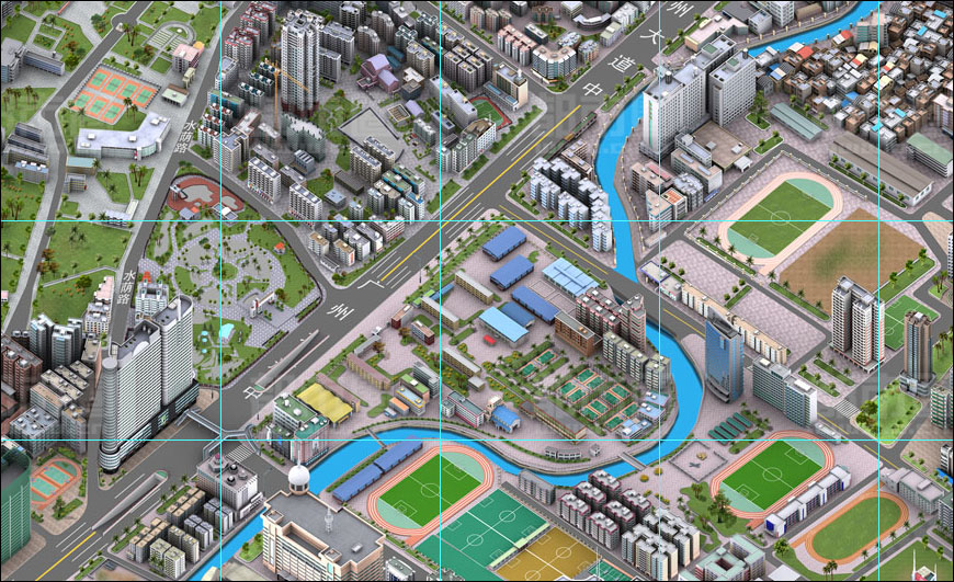
地图网站主要展现的就是地图图片,当查看或拖动地图的时候,看到的是一张完整的当前视窗地图图片,但实际上是一张张小图片拼凑而成。地图是拼凑而成那就涉及到图片是如何分割,分割的方法很多,我说一下其中一种:地图本来就是一张很大的图片,把大图当作放在二维坐标系中(单位像素),大图左上角为圆点,沿着坐标线一小块一小块的切下来,这里以256像素X256像素的正方形为一小块,切下来之后按照坐标点除以小图边长命名(比如某小块是从坐标(256,512)处开始切图,则文件名为1,2.jpg),这样就可以知道小图的位置了。网站上看到多种倍数的地图,也就是把大图缩写相应的倍数再按同样的规格切小图;不同类型的图片(比如航拍图,2D图)也就同样的道理了,至于怎么存放就按自己的思路存放,怎么存就怎么取出来。
Web中地图展现
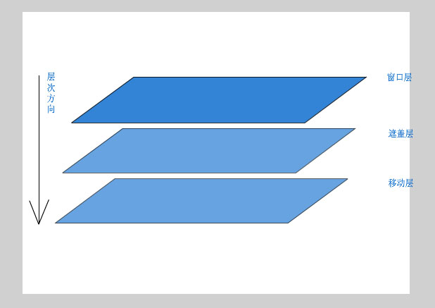
网页中展现地图是通过Div层实现,一个层是作为窗口,层的大小就是看到的地图大小(简称窗口层);一个层是用来拖动时随鼠标移动的层(简称移动层),前面说道大图是当作放在二维坐标系中,那么这个层就是充当这个坐标系,你需要显示哪张小图,就把小图拼在它切出来的坐标上,要知道显示哪张小图这就得通过当前定位的坐标(center)(定位的坐标就作为窗口层的中心位置)和窗口层的宽度(width)以及高度(height)计算出要拼上去的小图。
计算推理:
横向坐标范围:center.x-width/2 至 center.x+width/2
纵向坐标范围:center.y-height/2 至 center.y+height/2
小图是一块256像素的正方形,因此
小图横向下标范围:Math.floor((center.x-width/2)/256) 至 Math.floor((center.x+width/2)/256)
小图纵向下标范围:Math.floor((center.y-height/2)/256) 至 Math.floor((center.y+height/2)256)
通过以上下标范围就可以找到相应的图片,把图片显示在相应的坐标位置上,小图是拼凑得了,还要把镜头(窗口层)移动到center这个位置,窗口层是固定的不能移动,移动是相对的那就移动一下移动层吧
移动层的Left=width/2-center.x
移动层的top=height/2-center.y
这样简单的地图显示就可以实现了,看一下还有一个遮盖层,其实这层是透明的,不影响地图的显示,其作用是避免直接操作到地图图片,以及避免IE下出现图片工具条
还是来看看代码和效果吧
为了好测试,把代码都写在页面上了。 查看演示 (兼容IE和Firefox )
 <!DOCTYPE html PUBLIC "-//W3C//DTD XHTML 1.0 Transitional//EN" "http://www.w3.org/TR/xhtml1/DTD/xhtml1-transitional.dtd"><html xmlns="http://www.w3.org/1999/xhtml" ><head runat="server"> <title></title>
 <style type="text/css">

 body{
body{ body
body margin:0px;padding:0;
 } .test{background-color:black;} .test a{float:left;text-decoration: underline;color: white;background-color:black;display:block;width:200px;text-align:center} .test a:hover{float:left;text-decoration: underline;color: black;background-color:white;display:block;width:200px}
 </style> <script type="text/javascript"> // http://ghtyan.cnblogs.com 代码供大家学习 /*============================prototype.js中的部分函数================================*/ Object.extend = function(destination, source) { for (property in source) destination[property] = source[property]; return destination; } Function.prototype.bind = function(object) { var __method = this; return function() { return __method.apply(object, arguments); } } Function.prototype.bindAsEventListener = function(object) { var __method = this; return function(event) { return __method.call(object, event || window.event); } } function $() { if (arguments.length == 1) return get$(arguments[0]); function get$(el){ if (typeof el == 'string') el = document.getElementById(el); return el; } } /*============================基础类================================*/ function CPoint(x,y){ //坐标点 this.x=x; this.y=y; } function CSize(width,height){ //矩形区域 this.width=width; this.height=height; } function CBounds(p1,p2){ //矩形坐标范围,参数左上点和右下点组成 this.minX=p1.x; this.minY=p1.y; this.maxX=p2.x; this.maxY=p2.y; this.getSize=function(){ return new CSize(this.maxX-this.minX,this.maxY-this.minY); } } window.CEvent={ //自定义事件处理 addListener:function(obj,target,act){ if(obj.attachEvent) obj.attachEvent("on"+target,act); if(obj.addEventListener) obj.addEventListener(target,act,false); }, removeListener:function(obj,target,act){ if(obj.detachEvent) obj.detachEvent("on"+target,act); if(obj.removeEventListener) obj.removeEventListener(target,act,false); } } /*============================地图类================================*/ function CMap(div){ this.holder=div; //地图的载体,即窗口层 this.config={ imgsize:256 //小图边长 }; this._center; //实时中心点 this.mvl; //用于移动的层,即移动层 this.mouseopt={ //鼠标在地图上操作选项 down:false, //是否按下 move:false, //是否按下并移动过 dx:0,dy:0, //按下时移动层的left和top ex:0,ey:0 //按下时的事件坐标 }; this.mapimage=new Array();//当前显示的地图集合 this.cacheimage=new Array();//图片对象缓存,避免重复创建和删除IMG对象 } CMap.prototype = { _getimage:function(){//获取一个IMG对象 var img =this.cacheimage.shift(); if(img==null) {img=document.createElement("IMG");} return img; }, _loadmap:function(){//加载地图 var bounds=this.getBounds(); var x1=Math.floor(bounds.minX/this.config.imgsize); var x2=Math.ceil(bounds.maxX/this.config.imgsize); var y1=Math.floor(bounds.minY/this.config.imgsize); var y2=Math.ceil(bounds.maxY/this.config.imgsize); this.mvl.style.left=-bounds.minX+"px"; this.mvl.style.top=-bounds.minY+"px"; for(var y=y1;y<y2;y++) { for(var x=x1;x<x2;x++) { var img = this._getimage(); this.mapimage.push(img); img.style.position="absolute"; img.style.backgroundColor="#AEAEAE"; img.style.left=x*this.config.imgsize+"px"; img.style.top=y*this.config.imgsize+"px"; img.style.width=this.config.imgsize+"px"; img.style.height=this.config.imgsize+"px"; img.alt=x+","+y; this.mvl.appendChild(img); } } }, _resize:function(evt){ //地图resize事件,内部函数 this.onresize(); this._clearmap(); this._loadmap(); }, _mapmousedown:function(evt){ //记录鼠标操作信息 this.mouseopt.down=true; this.mouseopt.ex=evt.clientX; this.mouseopt.ey=evt.clientY; this.mouseopt.dx=this.mvl.offsetLeft; this.mouseopt.dy=this.mvl.offsetTop; //为了使鼠标移动到浏览器外部,事件依然有效,IE & firefox if(this.mvl.setCapture) this.mvl.setCapture(); else if(window.captureEvents) window.captureEvents(Event.MOUSEMOVE|Event.MOUSEUP); }, _mapmove:function(evt){ if(this.mouseopt.down==true) { //拖动时记录鼠标拖动过以及设定移动层的位置 this.mouseopt.move=true; this.mvl.style.left=this.mouseopt.dx+(evt.clientX-this.mouseopt.ex)+"px"; this.mvl.style.top=this.mouseopt.dy+(evt.clientY-this.mouseopt.ey)+"px"; } }, _mapmouseup:function(evt){ //取消事件捕捉 if(this.mvl.releaseCapture) this.mvl.releaseCapture(); else if(window.releaseEvents) window.releaseEvents(Event.MOUSEMOVE|Event.MOUSEUP); if(this.mouseopt.down==true&&this.mouseopt.move==true) { //重新设定实时中心位置 this._clearmap(); this._center.x=this.holder.offsetWidth/2-this.mvl.offsetLeft; this._center.y=this.holder.offsetHeight/2-this.mvl.offsetTop; this._loadmap(); } this.mouseopt.down=false; this.mouseopt.move=false; }, _clearmap:function(){//清除当前地图图片,放入图片缓存 var tm; while((tm=this.mapimage.pop())!=null){ this.mvl.removeChild(tm); this.cacheimage.push(tm); } } } CMap.prototype.init=function(){ //创建移动层 this.holder.style.overflow="hidden"; this.mvl=document.createElement("DIV"); this.mvl.style.cssText="position:absolute;left:0;top:0;z-index:1"; this.holder.appendChild(this.mvl); //创建遮盖层 this.cover=document.createElement("DIV"); this.cover.innerHTML=" "; this.cover.style.cssText="position:relative;left:0;top:0;z-index:2;width:2000px;height:2000px;background-color:gray;filter:alpha(opacity=0);opacity:0;"; this.holder.appendChild(this.cover); this._loadmap(); //事件绑定 CEvent.addListener(window,"resize",this._resize.bindAsEventListener(this)); CEvent.addListener(this.holder,"mousedown",this._mapmousedown.bindAsEventListener(this)); CEvent.addListener(this.holder,"mousemove",this._mapmove.bindAsEventListener(this)); CEvent.addListener(this.holder,"mouseup",this._mapmouseup.bindAsEventListener(this)); } CMap.prototype.reload=function(){ //外部强制重新加载地图 this._loadmap(); } CMap.prototype.onresize=function(evt){ //地图resize事件,供外部定义函数 } CMap.prototype.setCenter=function(p){ this._center = p; } CMap.prototype.getCenter=function(){ return this._center; } CMap.prototype.getBounds=function(){ //获取地图范围 var p1= new CPoint(this._center.x-this.holder.offsetWidth/2,this._center.y-this.holder.offsetHeight/2); var p2= new CPoint(this._center.x+this.holder.offsetWidth/2,this._center.y+this.holder.offsetHeight/2) return new CBounds(p1,p2); } </script></head><body> <div id="d_map" style="width:100%; background-color:gray; position:relative;overflow:hidden;"> </div></body></html><script type="text/javascript"> function fit(){ document.getElementById("d_map").style.height = document.documentElement.clientHeight+"px"; } fit(); var map = new CMap(document.getElementById("d_map")); map.setCenter(new CPoint(1024,2048)); map.init(); map.onresize=fit; </script>
暂时先写到这里了,有时间再继续下去~~~

 浙公网安备 33010602011771号