BeiDou-3 will reach millimeter-level accuracy
compass [Origin: compas 'measure, circle, compass', from compasser 'to measure', from Vulgar Latin compassare 'to measure by walking', from Latin com- ( COM-) + passus (PACE)]
- If something encompasses particular things, it includes them. =embrace
- To encompass a place means to completely surround or cover it.
- To encircle something or someone means to surround or enclose them, or to go round them. =surround
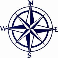
A compass is a magnetometer used for navigation and orientation that shows direction relative to the geographic cardinal [主要的; 基本的] directions (or points). Usually, a diagram called a compass rose shows the directions north, south, east, and west on the compass face as abbreviated initials. When the compass is used, the rose can be aligned with the corresponding geographic directions; for example, the "N" mark on the rose points northward. Compasses often display markings for angles in degrees in addition to (or sometimes instead of) the rose. North corresponds to 0°, and the angles increase clockwise, so east is 90° degrees, south is 180°, and west is 270°. These numbers allow the compass to show magnetic North azimuths or true North azimuths or bearings [方位], which are commonly stated in this notation. If magnetic declination [磁倾角] between the magnetic North and true North at latitude angle and longitude angle is known, then direction of magnetic North also gives direction of true North.
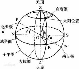
- azimuth: angle between this arc and the meridian [子午圈]
- bearing: direction in degrees as measured from a known position
几种meter: altimeter [高度计], barometer [气压计], diameter [measure across], parameter [para- measure], perimeter [peri- measure, 周长], voltmeter [电压计]
peri-: "around", "near".
A parameter (from the Ancient Greek παρά, para: "beside", "subsidiary"; and μέτρον, metron: "measure"), generally, is any characteristic that can help in defining or classifying a particular system (meaning an event, project, object, situation, etc.). That is, a parameter is an element of a system that is useful, or critical, when identifying the system, or when evaluating its performance, status, condition, etc. Parameter has more specific meanings within various disciplines, including mathematics, computer programming, engineering, statistics, logic, linguistics, electronic musical composition. Meaning of prefix para - by etymonline
subsidiary connected with, but less important than something else =secondary. parameter是第二位的,测量是第一位的。古希腊人有朴素的唯物主义思想。:-)
Among the Four Great Inventions, the magnetic compass was first invented as a device for divination [占卜; 预测] as early as the Chinese Han Dynasty (since c. 206 BC), and later adopted for navigation by the Song Dynasty Chinese during the 11th century. The first usage of a compass recorded in Western Europe and the Islamic world occurred around 1190. divine: coming from or relating to God or a god.
The Four Great Inventions refer to the four advanced achievements of science and technology from ancient China, which had a prominent position in the exchanges between the East and West. They are the compass, gunpowder, papermaking and printing.
The magnetic compass is the most familiar compass type. It functions as a pointer to "magnetic north", the local magnetic meridian, because the magnetized needle at its heart aligns itself with the horizontal component of the Earth's magnetic field. The magnetic field exerts a torque [扭转力] on the needle, pulling the North end or pole of the needle approximately toward the Earth's North magnetic pole, and pulling the other toward the Earth's South magnetic pole. The needle is mounted on a low-friction pivot point, in better compasses a jewel bearing [轴承], so it can turn easily. When the compass is held level [平], the needle turns until, after a few seconds to allow oscillations to die out, it settles into its equilibrium [平衡] orientation. bear: 承担; 肩负; 忍受; 承受…… 轴承:bear轴的。
- If you talk about the orientation of an organization or country, you are talking about the kinds of aims and interests it has.
- Someone's orientation is their basic beliefs or preferences.
- Orientation is basic information or training that is given to people starting a new job, school, or course. 新人培训
- The orientation of a structure or object is the direction it faces.
- torque [Origin: torquere 'to twist']
- torture [Origin: Late Latin tortura, from Latin tortus 'twisted', from torquere; TORQUE]
In navigation, directions on maps are usually expressed with reference to geographical or true north, the direction toward the Geographical North Pole, the rotation axis of the Earth. Depending on where the compass is located on the surface of the Earth the angle between true north and magnetic north, called magnetic declination can vary widely with geographic location. The local magnetic declination is given on most maps, to allow the map to be oriented with a compass parallel to true north. The locations of the Earth's magnetic poles slowly change with time, which is referred to as geomagnetic secular variation. The effect of this means a map with the latest declination information should be used. Some magnetic compasses include means to manually compensate for the magnetic declination, so that the compass shows true directions.
There are other ways to find north than the use of magnetism, and from a navigational point of view a total of seven possible ways exist (where magnetism is one of the seven). Two sensors that utilize two of the remaining six principles are often also called compasses, i.e. the gyrocompass and GPS-compass. A gyroscope [陀螺仪] is a device that contains a disc turning on an axis that can turn freely in any direction, so that the disc maintains the same position whatever the position or movement of the surrounding structure. A top a child's toy that spins around on its point when you twist it; "spin like a top" means "spin or turn round very quickly."
A gyrocompass is similar to a gyroscope. It is a non-magnetic compass that finds true north by using an (electrically powered) fast-spinning wheel and friction forces in order to exploit the rotation of the Earth. Gyrocompasses are widely used on ships.
GPS receivers using two or more antennae [天线] mounted separately and blending the data with an inertial motion unit (IMU) can now achieve 0.02° in heading accuracy and have startup times in seconds rather than hours for gyrocompass systems. The devices accurately determine the positions (latitudes, longitudes and altitude) of the antennae on the Earth, from which the cardinal directions can be calculated. Manufactured primarily for maritime and aviation applications, they can also detect pitch and roll of ships. Small, portable GPS receivers with only a single antenna can also determine directions if they are being moved, even if only at walking pace. By accurately determining its position on the Earth at times a few seconds apart, the device can calculate its speed and the true bearing (relative to true north) of its direction of motion. Frequently, it is preferable to measure the direction in which a vehicle is actually moving, rather than its heading, i.e. the direction in which its nose is pointing. These directions may be different if there is a crosswind or tidal current.
The BeiDou Navigation Satellite System (BDS) (北斗卫星导航系统) is a Chinese satellite navigation system. It consists of two separate satellite constellations. The first BeiDou system, officially called the BeiDou Satellite Navigation Experimental System and also known as BeiDou-1, consisted of three satellites which, beginning in 2000, offered limited coverage and navigation services, mainly for users in China and neighboring regions. BeiDou-1 was decommissioned [停用。de+commission] at the end of 2012. On 23 June 2020, the final BeiDou satellite was successfully launched, the launch of the 55th satellite in the Beidou family. The third iteration of the Beidou Navigation Satellite System promises to provide global coverage for timing [授时] and navigation, offering an alternative to Russia's GLONASS, the European Galileo positioning system, and America's GPS.
The second generation of the system, officially called the BeiDou Navigation Satellite System (BDS) and also known as COMPASS or BeiDou-2, became operational in China in December 2011 with a partial constellation of 10 satellites in orbit. Since December 2012, it has been offering services to customers in the Asia-Pacific region.
In 2015, China launched the third generation BeiDou system (BeiDou-3) for global coverage. The first BDS-3 satellite was launched on 30 March 2015. On 27 December 2018, BeiDou Navigation Satellite System started providing global services. The 35th and the final satellite of BDS-3 was launched into orbit on 23 June 2020. It was said in 2016 that BeiDou-3 will reach millimeter-level accuracy (with post-processing).
According to China Daily, in 2015, fifteen years after the satellite system was launched, it was generating a turnover of $31.5 billion per annum [each year] for major companies such as China Aerospace Science and Industry Corporation, AutoNavi Holdings Ltd. [高德], and China North Industries Group Corp.
AutoNavi Holdings Limited (NASDAQ:AMAP) is a provider of digital map content and navigation and location-based solutions in China. At the core of its business is a nationwide digital map database that covers approximately 3.3 million kilometers of roadway and over 20 million points of interest across China.
高德软件有限公司是中国数字地图、导航和位置服务解决方案提供商。公司于2010年登陆美国纳斯达克全球精品市场(Nasdaq:AMAP)。高德具备国家*导航电子地图测绘和航空摄影的“双甲”资质,其优质的电子地图数据库成为公司的核心竞争力。高德的业务覆盖三大领域: 互联网和移动互联网、车载导航、政府和企业应用。
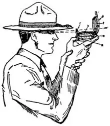 Soldier using a prismatic compass to get an azimuth
六级/考研单词: compass, vulgar, embrace, enclose, navigate, orient, cardinal, diagram, abbreviation, align, correspond, seldom, clockwise, latitude, longitude, meter, barometer, diameter, parameter, classify, situate, evaluate, mathematics, compute, logic, linguistic, electron, compose, dynasty, usage, divine, prominent, powder, needle, horizon, component, exert, mount, jewel, bearing, twist, torture, geography, rotate, axis, parallel, secular, manual, compensate, utilize, spin, friction, exploit, antenna, blend, data, inertia, heading, altitude, manufacture, maritime, aviation, detect, satellite, tertiary, globe, alternate, orbit, march, accord, turnover, billion, digit, nationwide, million

 浙公网安备 33010602011771号