电子围栏
1、找了个电子围栏算法,也就是多边形找点,在图形内还是图形外
#!/usr/bin/env python
# -*- coding: utf-8 -*-
import json
import math
lnglatlist = []
data = '[{"name":"武汉市三环","points":[{"lng":114.193437,"lat":30.513069},{"lng":114.183376,"lat":30.509211},{"lng":114.188191,"lat":30.505291},{"lng":114.187975,"lat":30.504731},{"lng":114.201773,"lat":30.492782},{"lng":114.213559,"lat":30.48855},{"lng":114.239143,"lat":30.484006},{"lng":114.248341,"lat":30.470062},{"lng":114.267888,"lat":30.470062},{"lng":114.286286,"lat":30.46309},{"lng":114.294335,"lat":30.459105},{"lng":114.298934,"lat":30.459105},{"lng":114.305833,"lat":30.459105},{"lng":114.341478,"lat":30.453128},{"lng":114.422613,"lat":30.462591},{"lng":114.424337,"lat":30.453688},{"lng":114.444316,"lat":30.456303},{"lng":114.466809,"lat":30.466078},{"lng":114.473708,"lat":30.549713},{"lng":114.443813,"lat":30.624326},{"lng":114.407593,"lat":30.683478},{"lng":114.388621,"lat":30.703352},{"lng":114.3616,"lat":30.704843},{"lng":114.311582,"lat":30.678466999999998},{"lng":114.241442,"lat":30.64123},{"lng":114.201773,"lat":30.63079},{"lng":114.182226,"lat":30.63427},{"lng":114.165553,"lat":30.626812},{"lng":114.162679,"lat":30.6109},{"lng":114.170153,"lat":30.59598},{"lng":114.167853,"lat":30.552201},{"lng":114.179351,"lat":30.529309}],"type":0}]'
data = json.loads(data)
if 'points' in data[0]:
    for point in data[0]['points']:
        #print(str(point['lng'])+" "+str(point['lat']))
        lnglat = []
        lnglat.append(float(str(point['lng'])))
        lnglat.append(float(str(point['lat'])))
        lnglatlist.append(lnglat)

def windingNumber(point, poly):
    poly.append(poly[0])
    px = point[0]
    py = point[1]
    sum = 0
    length = len(poly)-1

    for index in range(0,length):
        sx = poly[index][0]
        sy = poly[index][1]
        tx = poly[index+1][0]
        ty = poly[index+1][1]

        #点与多边形顶点重合或在多边形的边上
        if((sx - px) * (px - tx) >= 0 and (sy - py) * (py - ty) >= 0 and (px - sx) * (ty - sy) == (py - sy) * (tx - sx)):
            return "on"
        #点与相邻顶点连线的夹角
        angle = math.atan2(sy - py, sx - px) - math.atan2(ty - py, tx - px)

        #确保夹角不超出取值范围(-π 到 π)
        if(angle >= math.pi):
            angle = angle - math.pi * 2
        elif(angle <= -math.pi):
            angle = angle + math.pi * 2
        sum += angle

        #计算回转数并判断点和多边形的几何关系
    result = 'out' if int(sum / math.pi) == 0 else 'in'
    return result

point = [114.193437,30.513068]
print(windingNumber(point,lnglatlist))
转自
http://blog.51cto.com/yixianwei/2089075
2、我的项目json文件比较复杂,需要用个二维数据来存储坐标数据
#!/usr/bin/env python
# -*- coding: utf-8 -*-
import json
import math

def windingNumber(point, poly):
    poly.append(poly[0])
    px = point[0]
    py = point[1]
    sum = 0
    length = len(poly)-1

    for index in range(0,length):
        sx = poly[index][0]
        sy = poly[index][1]
        tx = poly[index+1][0]
        ty = poly[index+1][1]

        #点与多边形顶点重合或在多边形的边上
        if((sx - px) * (px - tx) >= 0 and (sy - py) * (py - ty) >= 0 and (px - sx) * (ty - sy) == (py - sy) * (tx - sx)):
            return "on"
        #点与相邻顶点连线的夹角
        angle = math.atan2(sy - py, sx - px) - math.atan2(ty - py, tx - px)

        #确保夹角不超出取值范围(-π 到 π)
        if(angle >= math.pi):
            angle = angle - math.pi * 2
        elif(angle <= -math.pi):
            angle = angle + math.pi * 2
        sum += angle

        #计算回转数并判断点和多边形的几何关系
    result = 'out' if int(sum / math.pi) == 0 else 'in'
    return result


if __name__ == "__main__":

    with open("railwayFence.json", 'r') as f:
        data = json.loads(f.read())
        data = data['railwayFence']
        #print(len(data))
        #print(data[65]['areaName'])

    lnglatlist = [[]]*len(data)
    point_test = [115.259161584,38.813623816]
    point_test1 = [115.243922249,38.836012517]

    for i in range(0,len(data)):
        for point in data[i]['coordinates']:
            #print(str(point['L'])+" "+str(point['B']))
            lnglat = []
            lnglat.append(float(str(point['L'])))
            lnglat.append(float(str(point['B'])))
            lnglatlist[i].append(lnglat)
        ret = windingNumber(point_test1,lnglatlist[i])

        if ret == 'in' or ret == 'on':
            break

    print ret
3、解析出json中的坐标点,可以描出电子围栏,打点测试就很方便了
test.txt
截取几个点,格式如下
38.836013 115.243822
38.836012 115.243818
38.836013 115.243813
38.836013 115.243809
38.836015 115.243805
38.836017 115.243801
38.836019 115.243898
38.836022 115.243895
38.836023 115.243895
38.836092 115.243850
38.836160 115.243806
38.836189 115.243788
38.836218 115.243769
38.836416 115.243642
38.836613 115.243515
38.837036 115.243243
plot.py
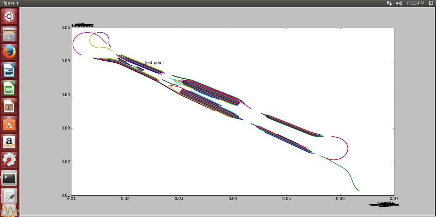
#!/usr/bin/env python
# -*- coding: utf-8 -*-

import matplotlib.pyplot as plt
import numpy as np
import json

with open("railwayFence.json", 'r') as f:
    data = json.loads(f.read())
    data = data['railwayFence']
    fo = open("tmp", "w")
    for i in range(0,len(data)):
        for point in data[i]['coordinates']:
            d = '%(x).9f %(y).9f\n'%{'x':float(str(point['B'])),'y':float(str(point['L']))}
            fo.write( d )
    fo.close()

data = np.loadtxt('tmp')
plt.plot(data[:,0],data[:,1])

#plt.annotate('test point', xy=(39.82775139,116.250658818),arrowprops=dict(facecolor='red', shrink=0))
#plt.annotate('test point', xy=(39.823400546,116.25345992),arrowprops=dict(facecolor='red', shrink=0))
plt.annotate('test point', xy=(39.813623816,116.259161584),arrowprops=dict(facecolor='red', shrink=0))
plt.show()
python plot.py
4、计算单个围栏
#!/usr/bin/env python
# -*- coding: utf-8 -*-
import json
import math
lnglatlist = []

with open("65.json", 'r') as f:
    data = json.loads(f.read())
    #print(data)
    print(data['areaName'])

#data = json.loads(data)
if 'coordinates' in data:
    for point in data['coordinates']:
        #print(str(point['L'])+" "+str(point['B']))
        lnglat = []
        lnglat.append(float(str(point['L'])))
        lnglat.append(float(str(point['B'])))
        lnglatlist.append(lnglat)

def windingNumber(point, poly):
    poly.append(poly[0])
    px = point[0]
    py = point[1]
    sum = 0
    length = len(poly)-1

    for index in range(0,length):
        sx = poly[index][0]
        sy = poly[index][1]
        tx = poly[index+1][0]
        ty = poly[index+1][1]

        #点与多边形顶点重合或在多边形的边上
        if((sx - px) * (px - tx) >= 0 and (sy - py) * (py - ty) >= 0 and (px - sx) * (ty - sy) == (py - sy) * (tx - sx)):
            return "on"
        #点与相邻顶点连线的夹角
        angle = math.atan2(sy - py, sx - px) - math.atan2(ty - py, tx - px)

        #确保夹角不超出取值范围(-π 到 π)
        if(angle >= math.pi):
            angle = angle - math.pi * 2
        elif(angle <= -math.pi):
            angle = angle + math.pi * 2
        sum += angle

        #计算回转数并判断点和多边形的几何关系
    result = 'out' if int(sum / math.pi) == 0 else 'in'
    return result

point = [115.259161584,38.813623816]
print(windingNumber(point,lnglatlist))
5、展示单个围栏
#!/usr/bin/env python
# -*- coding: utf-8 -*-

import matplotlib.pyplot as plt
import numpy as np
import json

'''
with open("railwayFence.json", 'r') as f:
    data = json.loads(f.read())
    data = data['railwayFence']
    fo = open("tmp", "w")
    for i in range(0,len(data)):
        for point in data[i]['coordinates']:
            d = '%(x).9f %(y).9f\n'%{'x':float(str(point['B'])),'y':float(str(point['L']))}
            fo.write( d )
    fo.close()
'''

data = np.loadtxt('65.txt')
plt.plot(data[:,0],data[:,1])

#plt.annotate('test point', xy=(38.82775139,115.250658818),arrowprops=dict(facecolor='red', shrink=0))
#plt.annotate('test point', xy=(38.823400546,115.25345992),arrowprops=dict(facecolor='red', shrink=0))
plt.annotate('test point', xy=(38.813623816,115.259161584),arrowprops=dict(facecolor='red', shrink=0))
plt.show()
6、用c语言解析json也行
main.c
/*
        reference documentation
        https://blog.csdn.net/stsahana/article/details/79638992
        https://blog.csdn.net/fengxinlinux/article/details/53121287
*/
#include <stdio.h>
#include <stdlib.h>
#include <stdbool.h>
#include <string.h>
#include "cJSON.h"

char *json_file_path = "./railwayFence.json";

char *json_loader(char *path)
{
  FILE *f;
  long len;
  char *content;
  f=fopen(path,"rb");
  fseek(f,0,SEEK_END);
  len=ftell(f);
  fseek(f,0,SEEK_SET);
  content=(char*)malloc(len+1);
  fread(content,1,len,f);
  fclose(f);
  return content;
}

int main(void)
{
    FILE *fp1;
    fp1=fopen("test.txt","w+");

    char *json_str = json_loader(json_file_path);

        cJSON *root=cJSON_Parse(json_str);
        if (!root) {
            printf("Error before: [%s]\n",cJSON_GetErrorPtr());
        }

        //railwayFence array
        cJSON *railwayFenceArray = cJSON_GetObjectItem(root, "railwayFence");
        if(!railwayFenceArray){
            printf("Error before: [%s]\n",cJSON_GetErrorPtr());
        }
        int railwayFence_array_size = cJSON_GetArraySize(railwayFenceArray);
        printf("railwayFence array size is %d\n",railwayFence_array_size);
        int i = 0;
        char *p  = NULL;
        cJSON *it;
        for(i=0; i< railwayFence_array_size; i++) {
                FILE *fp;
                char  buffer[32];
                sprintf( buffer, "./data/%d.txt", i );
                fp=fopen(buffer,"w+");
            cJSON *railwayFenceItem = cJSON_GetArrayItem(railwayFenceArray,i);
            p = cJSON_PrintUnformatted(railwayFenceItem);
            it = cJSON_Parse(p);
            if(!it)
            continue ;

            cJSON *areaName,*dangerType;
            areaName = cJSON_GetObjectItem(it, "areaName");
            printf("areaName is %s\n",areaName->valuestring);
            dangerType = cJSON_GetObjectItem(it, "dangerType");
            printf("dangerType is %s\n",dangerType->valuestring);

            //Coordinate array
            cJSON *CoordinateArray = cJSON_GetObjectItem(railwayFenceItem, "coordinates");
            if(!CoordinateArray){
                printf("Error before: [%s]\n",cJSON_GetErrorPtr());
            }
            int Coordinate_array_size = cJSON_GetArraySize(CoordinateArray);
            printf("Coordinate array size is %d\n",Coordinate_array_size);
            int j = 0;
            char *q  = NULL;
            cJSON *jt;
            for(j=0; j< Coordinate_array_size; j++) {
                cJSON *CoordinateItem = cJSON_GetArrayItem(CoordinateArray,j);
                q = cJSON_PrintUnformatted(CoordinateItem);
                jt = cJSON_Parse(q);
                if(!jt)
                    continue ;

                cJSON *B,*L;
                B = cJSON_GetObjectItem(jt, "B");
                printf("B is %f\n",B->valuedouble);
                L = cJSON_GetObjectItem(jt, "L");
                printf("L is %f\n",L->valuedouble);
                fprintf(fp1,"%f %f\n",B->valuedouble,L->valuedouble);
                fprintf(fp,"%f %f\n",B->valuedouble,L->valuedouble);

                free(q); cJSON_Delete(jt);
            }
            free(p); cJSON_Delete(it);
        }
        if(root) {
            cJSON_Delete(root);
                //return 0;
        }

  return 0;
}
Makefile

OBJ= main
all: ${OBJ}
main:
    gcc -g -o main main.c cJSON.c -lm

clean:
    rm -f ${OBJ}
.PHONY: ${OBJ}
7、nodejs解析json文件更简单
main.js
var fs = require("fs");
var contents = fs.readFileSync("railwayFence.json");
var obj = JSON.parse(contents);
//console.log("<<<<<<<<<<<<<<<<<<<<"+JSON.stringify(obj));
for(var i in obj.railwayFence){
    console.log('>>>>>>>>>>>>>>>>>>>>>>>>put areaName: ' + obj.railwayFence[i].areaName)
    console.log('>>>>>>>>>>>>>>>>>>>>>>>>put dangerTypeName: ' + obj.railwayFence[i].danggerTypeName)
    for(var j in obj.railwayFence[i].coordinates){
        console.log('>>>>>>>>>>>>>>>>>>>>>>>>put B: ' + obj.railwayFence[i].coordinates[j].B)
        console.log('>>>>>>>>>>>>>>>>>>>>>>>>put L: ' + obj.railwayFence[i].coordinates[j].L)
    }
}
8、同事找的c算法,记录一下
/**
 * 功能:判断点是否在多边形内
 * 方法:求解通过该点的水平线(射线)与多边形各边的交点
 * 结论:单边交点为奇数,成立!
 * 参数:p 指定的某个点
         ptPolygon 多边形的各个顶点坐标(首末点可以不一致)
         nCount 多边形定点的个数
 * 说明:
 */
// 注意:在有些情况下x值会计算错误,可把double类型改为long类型即可解决。
int PtInPolygon(Point_t* p, Point_t* ptPolygon, int nCount)
{
    int nCross = 0, i;
    double x;
    Point_t p1, p2;

    for (i = 0; i < nCount; i++)
    {
        p1 = ptPolygon[i];
        p2 = ptPolygon[(i + 1) % nCount];
        // 求解 y=p->y 与 p1p2 的交点
        if ( p1.y == p2.y ) // p1p2 与 y=p->y平行
            continue;
        if ( p->y < min(p1.y, p2.y) ) // 交点在p1p2延长线上
            continue;
        if ( p->y >= max(p1.y, p2.y) ) // 交点在p1p2延长线上
            continue;
        // 求交点的 X 坐标 --------------------------------------------------------------
        x = (double)(p->y - p1.y) * (double)(p2.x - p1.x) / (double)(p2.y - p1.y) + p1.x;
        if ( x > p->x )
        {
            nCross++; // 只统计单边交点
        }
    }
    // 单边交点为偶数,点在多边形之外 ---
    return (nCross % 2 == 1);
}

/*******************************************************************************
 * 名称: pointInPolygon
 * 功能: 当前平面坐标点是否在区域面内
 * 形参: point:需判断点
 *      points:区域面点集合
 *      count:区域面点个数
 * 返回: 判断结果 1在区域内 0在区域外
 * 说明: 无
 ******************************************************************************/
int pointInPolygon(Point_t *point, Point_t *points,int count)
{
 int   i,j=count-1 ;
 int  oddNodes = 0 ;
 double  x,y;

 if(point == NULL || points == NULL)
  return -1;

 x = point->x, y = point->y;
 for (i=0;i<count; i++)
 {
  if((points[i].y< y && points[j].y>=y
   || points[j].y<y && points[i].y>=y)
   && (points[i].x<=x || points[j].x<=x))
  {
   oddNodes^=(points[i].x+(y-points[i].y)/(points[j].y-points[i].y)*(points[j].x-points[i].x)<x);
  }
  j=i;
 }

  return oddNodes;
}
怎么处理都行,怎么方便怎么用。
end

 浙公网安备 33010602011771号