DSSAT模型初探-1
July-Week1
使用DSSAT时遇见的问题:

ERROR.OUT文件:
*RUN-TIME ERRORS OUTPUT FILE
*DSSAT Cropping System Model Ver. 4.8.0.027 -release JUL 03, 2023 17:47:26
*RUN 1 : Treatment 1 MZCER048 EBPL8701 1
MODEL : MZCER048 - Maize
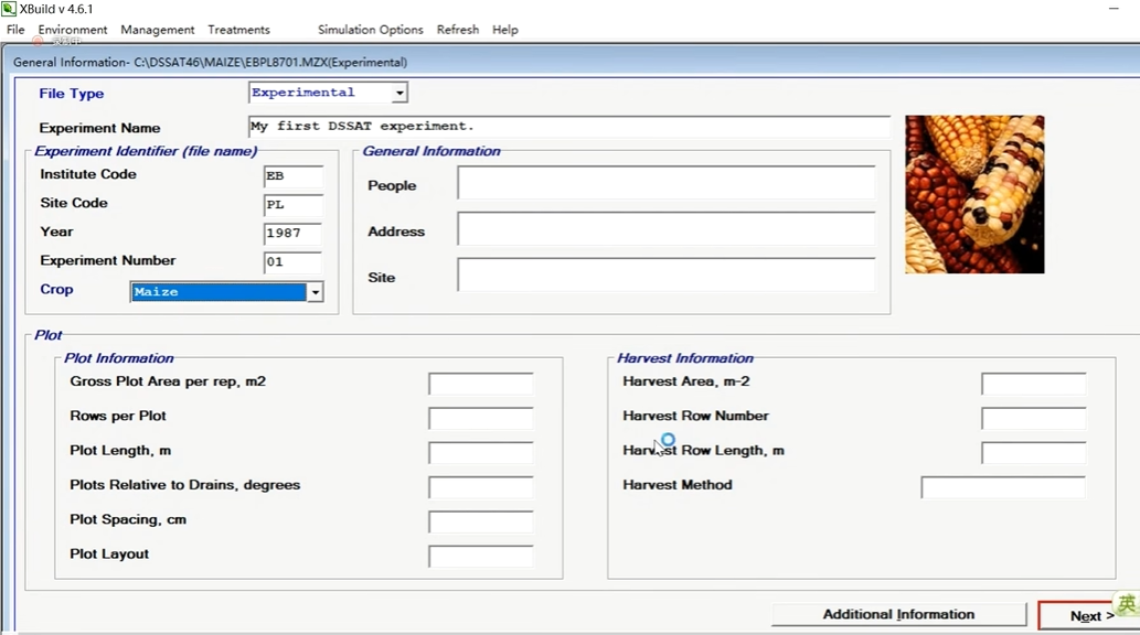
EXPERIMENT : EBPL8701 MZ MY FIRST DSSAT EXPERIMENT.
DATA PATH : C:\DSSAT48\Maize\
TREATMENT 1 : Treatment 1 MZCER048
EBPL8701.MZX, Trt 1
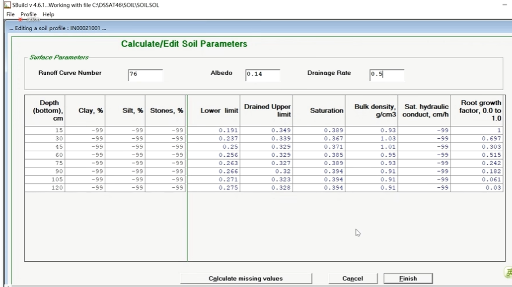
Saturated water content (SAT) is LESS than drained upper limit. Fix input file
.
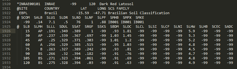
File: SOIL.SOL Line: 1926 Error key: IPSOIL
Additional information may be available in WARNING.OUT file.
RunList.OUT文件:
 NREP  EXP  TRT  NYR FILEX        DESCRIPTION
    1    1    1    1 EBPL8501.MZX
    2    1    2    1 EBPL8501.MZX
    3    1    3    1 EBPL8501.MZX
    4    1    4    1 EBPL8501.MZX
WARNING.OUT文件:
*WARNING DETAIL FILE

******************************************************************************

*DSSAT Cropping System Model Ver. 4.8.0.027 -release  JUL 03, 2023 17:47:26

*RUN   1        : Treatment 1                        EBPL8701    1

 EXPERIMENT     : EBPL8701 MZ MY FIRST DSSAT EXPERIMENT.
 DATA PATH      : C:\DSSAT48\Maize\
 TREATMENT  1   : Treatment 1


 IPEXP   YEAR DOY =    0   0
 Photosynthesis method (PHOTO in FILEX) has been changed
 from "L" to "C" for compatibility with crop model, MZCER.

 IPSOIL  YEAR DOY =    0   0
 Saturated water content (SAT) is LESS than drained upper limit.  Fix input fi
 File: SOIL.SOL
    Line:  1926
    Error key: IPSOIL
 Simulations terminated.
chatGPT给出的分析:
错误类型: Saturated water content (SAT) is LESS than drained upper limit. 错误文件: SOIL.SOL 错误行号: 1926 错误代码: IPSOIL
根据错误信息,饱和含水量 (SAT) 小于排水上限 (drained upper limit)。这可能表示在 SOIL.SOL 文件的第 1926 行存在问题。您需要检查该行的输入值,确保饱和含水量不低于排水上限。您可以打开 SOIL.SOL 文件,查找第 1926 行并检查相关的数值。
此外,根据 WARNING.OUT 文件的内容,还有一个警告信息指出光合作用方法 (Photosynthesis method) 已从 "L" 更改为 "C",以与作物模型 MZCER 兼容。
请注意,还提供了 RunList.OUT 文件,其中列出了运行列表中的实验、处理和文件名。这些信息可能对进一步分析有用。
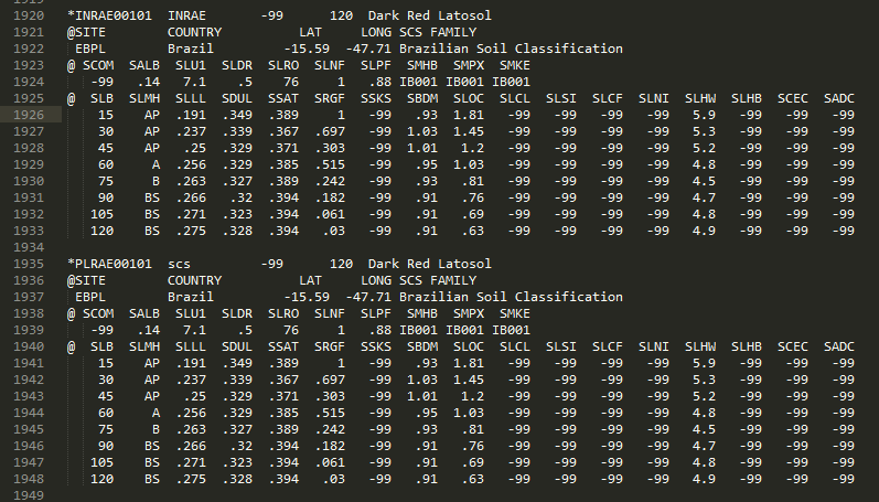
SOIL.SOL文件:
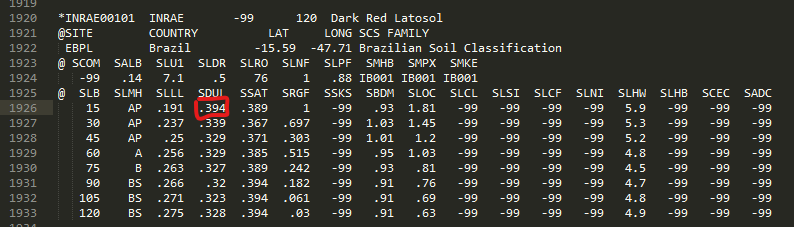
我们发现此处应该为0.349,而不是0.394
再次运行DSSAT模型后发现实验输出文件一致。
接下来分析出错原因:
先附上代码解释:
SOIL.CDE文件:
LAT      Latitude, degrees (decimals;+ve north)
LONG     Longitude, degrees (decimals;+ve east)
SCSFAM   Family, US NRCS system, formerly SCS
SCOM     Color, moist, Munsell hue
SALB     Albedo, fraction
SLU1     Stage 1 evaporation limit, mm
SLDR     Drainage rate, fraction day-1
SLRO     Runoff curve no. [Soil Conservation Service/NRCS]
SLNF     Mineralization factor, 0 to 1 scale
SLPF     Soil fertility factor, 0 to 1 scale [for soil factors not simulated by the model]
SMHB     pH in buffer determination method, code
SMPX     Phosphorus determination code
SMKE     Potassium determination method, code


SLB      Depth, base of layer, cm
SLMH     Master horizon
SLLL     Lower limit of plant extractable soil water, cm3 cm-3
SDUL     Drained upper limit, cm3 cm-3
SSAT     Upper limit, saturated, cm3 cm-3
SRGF     Root growth factor, soil only, 0.0 to 1.0
SSKS     Sat. hydraulic conductivity, macropore, cm h-1
SBDM     Bulk density, moist, g cm-3
SLOC     Organic carbon, %
SLCL     Clay (<0.002 mm), %
SLSI     Silt (0.05 to 0.002 mm), %
SLCF     Coarse fraction (>2 mm), %
SLNI     Total nitrogen, %
SLHW     pH in water
SLHB     pH in buffer
SCEC     Cation exchange capacity, cmol kg-1
SADC     Anion adsorption coefficient (reduced nitrate flow), cm3 (H2O) g [soil]-1

LAT 纬度, 度数(小数;北向)
LONG 经度,度数(小数;+东经)。
SCSFAM 系列,美国 NRCS 系统,以前是 SCS。
SCOM 颜色,潮湿,Munsell色调
SALB 反照率,分数
SLU1 第一阶段蒸发极限,毫米
SLDR 排水率,分量日-1
SLRO 径流曲线No. [土壤保护局/NRCS]
SLNF 矿化系数,0-1比例
SLPF 土壤肥力系数,0到1的比例[用于模型未模拟的土壤因素] 。
SMHB 缓冲区内 pH 值测定方法,代码
SMPX 磷测定代码
SMKE 钾测定法,代码

SLB 深度,层底,厘米
SLMH 主地层
SLLL 植物可提取土壤水分的下限,cm3 cm-3
SDUL 排水上限,cm3 cm-3
SSAT 饱和的上限,cm3 cm-3
SRGF 根系生长因子,仅土壤,0.0至1.0
SSKS 饱和导水率,大孔,cm h-1
SBDM 体积密度,湿润,g cm-3
SLOC 有机碳,百分比
SLCL 粘土(小于0.002毫米),百分比
SLSI 淤泥(0.05 至 0.002 毫米),%。
SLCF 粗粒部分(>2毫米),百分比
SLNI 总氮,百分比
SLHW 水中的pH值
SLHB 缓冲液中的pH值
SCEC 阳离子交换能力,cmol kg-1
SADC 阴离子吸附系数(硝酸盐流量减少),cm3(H2O)g[土壤]-1
SDUL和SSAT之间存在密切联系,它们都是描述土壤水分特性的参数,但从不同的角度进行描述。
-
SDUL(排水上限):它表示土壤在饱和状态下可以排出的剩余水分量。换句话说,当土壤处于饱和状态时,SDUL表示剩余在土壤孔隙中的水分量。SDUL通常比SSAT小,因为它考虑了土壤中存在的排水能力。
-
SSAT(饱和的上限):它表示土壤的最大容水量,即土壤完全饱和状态下所能容纳的水分量。SSAT通常大于SDUL,因为它考虑了土壤孔隙的总容积。
可以说,SDUL是饱和状态下土壤中的剩余水分量,而SSAT是土壤中总的可容纳水分量。它们一起描述了土壤的水分保持能力和排水能力。
根据错误信息,饱和含水量 (SAT) 小于排水上限 (DUL,drained upper limit),即0.389(SSAT) < 0.394(SDUL)
经过检查发现SDUL应该为0.349 < 0.389(SSAT)
Tips
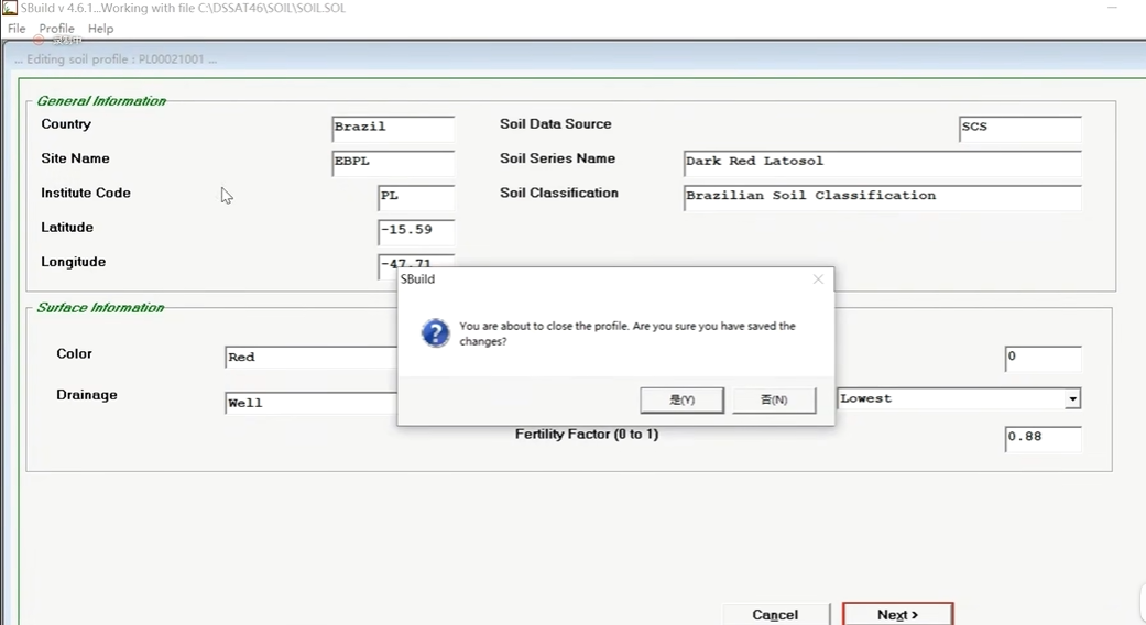
更改实验数据时,最好不要在shell软件中更改,它可能会导致(不知名原因)创建一个新的实验文件!所以最好直接在底层文件中进行更改。
DSSAT模型如何产出农事处方图
DSSAT模型可以通过以下步骤产出农事处方图:
-
数据收集与准备:收集所需的土壤数据、气象数据、作物品种特性和管理实践等相关数据。确保数据准确性和完整性。
-
模型设置:使用DSSAT模型的相应软件(如DSSAT-CSM)进行模型设置。输入土壤、气象、作物和管理数据,包括土壤性质、种植日期、施肥计划、灌溉方案等。
-
模拟运行:运行DSSAT模型进行模拟。根据设定的参数和管理措施,模型将模拟作物的生长、发育、产量和其他农艺特性。
-
结果分析:分析模拟结果,包括作物产量、水分利用效率、养分利用效率等。通过对比不同管理方案的模拟结果,评估其对作物产量和农艺特性的影响。
-
农事处方图生成:根据模拟结果,生成农事处方图。农事处方图可以包括作物种植日期、施肥量、灌溉量、病虫害防治策略等农事管理建议。这些建议是根据模拟结果和特定的土地条件、作物品种来推荐的。
-
解读与应用:解读农事处方图,并根据实际情况进行调整和应用。根据农田实际的土壤状况、气象变化和管理能力等因素,调整农事处方图中的参数和建议。
需要注意的是,DSSAT模型的准确性和可靠性取决于输入数据的质量和模型参数的准确性。因此,在使用DSSAT模型进行农事处方图生成之前,确保收集准确的数据并进行适当的参数化和校准是非常重要的。
此外,DSSAT模型还提供了丰富的图形和统计功能,可用于进一步分析和展示模拟结果。这些工具可以帮助农户、农业专家和决策者更好地理解模拟结果并做出相应的农事管理决策。
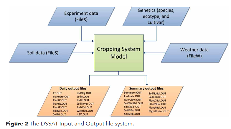
DSSAT模型/CSM的输入与输出
* file or section heading 文件或章节标题
@ header line specifying variables occurring below 标题行指定下面出现的变量
! Comment line. 注释行
Extensions
.WTH Weather data file
.SOL Soil profile data file
.CUL Cultivar/variety specific coefficient file
.ECO Ecotype specific coefficient file
.SPE Crop (species) specific coefficient file
.OUT Output file generated by the crop model
.LST A list file - provides a list of either experiments, weather data sets or soil data sets
.ccX Experiment details file (i.e., FILEX)
.ccA Average values of observation data
.ccT Time course data (averages)
The ‘cc’ in the above extensions indicates a crop code (e.g., WH)
Prefixes
For most model input files and experiment observation files, the prefix is constructed from an institute code (2 characters), a site code (2 characters), the year of the experiment (2 characters) and an experiment number (2 characters). For example, an experiment conducted by the University of Florida (UF) at Gainesville (GA) in 1988 (88) would yield a file prefix of UFGA8801. The file prefix conventions used for output files and genotype coefficient files are shown in Table 1.
输入数据
模型运行所需输入数据
气象数据 FileW
Weather Data:****(气象数据)
The weather data were recorded daily at the site. The weather file EBPL is already part of distribution version of DSSAT Version 4.5. View the file and check the information. Alternatively you can enter the weather data in WeatherMan. Make sure to name the station EBPP!
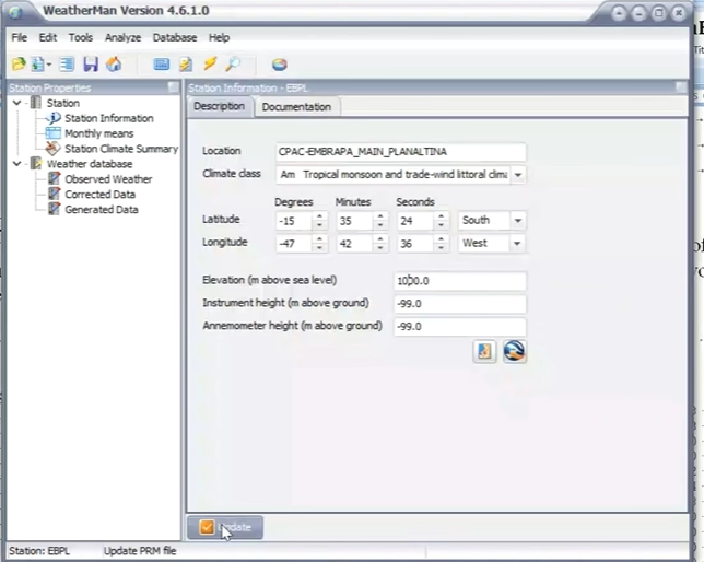
CPAC-EMBRAPA_MAIN_PLANALTINA; Latititude -15.590 longitude -47.710 elevation: 1000 (气象站、纬度、经度、海拔高度)
Date SRAD TMax Tmin Rain
87001 15.5 28.6 18.2 3.1 87150 15.2 27.8 14.4 0.0 87299 16.1 30.2 16.8 0.0
87002 19.0 28.8 17.5 0.0 87151 16.1 27.2 12.8 0.0 87300 20.6 32.8 16.8 0.0
87003 21.3 30.8 18.4 0.0 87152 16.1 27.4 11.4 0.0 87301 20.5 33.2 16.0 0.0
......
EBPL8701.WTH
WEATHER.CDE
$WEATHER DATA : CPAC-EMBRAPA_MAIN_PLANALTINA

@ INSI      LAT     LONG  ELEV   TAV   AMP REFHT WNDHT
  EBPL   14.410   46.290  1000   0.0   0.0 -99.0 -99.0
@  DATE  SRAD  TMAX  TMIN  RAIN
1987001  15.5  28.6  18.2   3.1
1987002  19.0  28.8  17.5   0.0
1987003  21.3  30.8  18.4   0.0
...
  87365  16.1  29.4  17.9   1.8
...........................................................
INSI     Institute and site code    INSI 研究所和站点代码
LAT      Latitude, degrees (decimals)   纬度,度数(小数)
LONG     Longitude, degrees (decimals)  经度,度数(小数)
ELEV     Elevation, m     海拔高度,米
TAV      Temperature average for whole year [long-term], C  全年平均温度[长期],摄氏度
REFHT    Reference height for weather measurements, m  气象测量的参考高度,米
WNDHT    Reference height for windspeed measurements, m   用于风速测量的参考高度,m
DATE     Date, year + days from Jan. 1   日期,从1月1日起算的年+日
SRAD     Daily solar radiation, MJ m-2 day-1     每日太阳辐射,MJ m-2 day-1
TMAX     Daily temperature maximum, C   每日最高温度,C
TMIN     Daily temperature minimum, C   每日最低温度,C
RAIN     Daily rainfall (incl. snow), mm day-1   日降雨量(包括雪),毫米日-1
操作
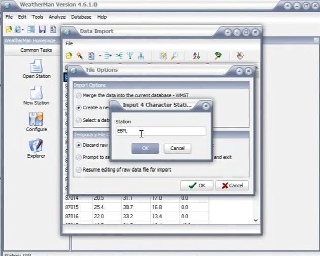
Weather Data -> File -> New Station -> Input or import raw weather data and then save as a new station -> go -> open file -> Weather data.txt(自己创建的气象文件) -> 右键 给参数命名 -> File -> Import data into WM

需要update!
File -> Save Station -> Write File 此时会创建成功创建"C:\DSSAT48\Weather\EBPL8701.WTH"
此处出错误!1.0没有改。。。multiplier没改
土壤数据 FileS
Soil Profile:
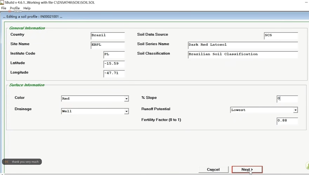
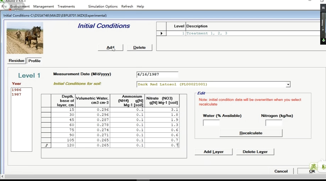
The soil at the site is classified as a Dark Red Latosol(砖红土) in the Brazilian Soil Classification system. The DUL and LL were estimated in the field. The properties of the soil are given below:
(地表信息:)
Albedo (SALB) = 0.14(反射率), Upper limit constant (SLU1) = 7.1(上限常量)
SWCON (SLDR) = 0.5(蒸发上限), Runoff curve number (SLRO) = 76.0(地表径流曲线数)
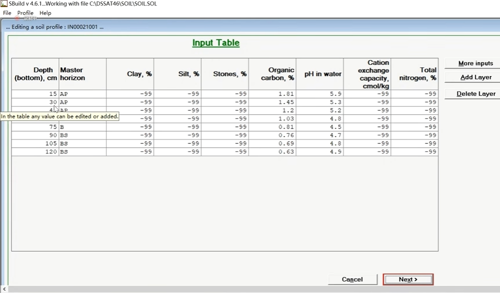
(土壤剖面信息:创建土壤数据时使用)
SLB  SLMH SLLL SDUL SSAT SRGF SBDM  SLOC SLHW

 15 0.00 0.191 0.349 0.389 1.000 0.93 1.81  5.9

 30 0.00 0.237 0.339 0.367 0.697 1.03 1.45  5.3

 45 0.00 0.250 0.329 0.371 0.303 1.01 1.20  5.2

 60 0.00 0.256 0.329 0.385 0.515 0.95 1.03  4.8

 75 0.00 0.263 0.327 0.389 0.242 0.93 0.81  4.5

 90 0.00 0.266 0.320 0.394 0.182 0.91 0.76  4.7

105  0.00 0.271 0.323 0.394 0.061 0.91 0.69  4.8

120  0.00 0.275 0.328 0.394 0.030 0.91 0.63  4.9
"C:\DSSAT48\Soil\SOIL.SOL"
LAT      Latitude, degrees (decimals;+ve north)
LONG     Longitude, degrees (decimals;+ve east)
SCSFAM   Family, US NRCS system, formerly SCS
SCOM     Color, moist, Munsell hue
SALB     Albedo, fraction
SLU1     Stage 1 evaporation limit, mm
SLDR     Drainage rate, fraction day-1
SLRO     Runoff curve no. [Soil Conservation Service/NRCS]
SLNF     Mineralization factor, 0 to 1 scale
SLPF     Soil fertility factor, 0 to 1 scale [for soil factors not simulated by the model]
SMHB     pH in buffer determination method, code
SMPX     Phosphorus determination code
SMKE     Potassium determination method, code


SLB      Depth, base of layer, cm
SLMH     Master horizon
SLLL     Lower limit of plant extractable soil water, cm3 cm-3
SDUL     Drained upper limit, cm3 cm-3
SSAT     Upper limit, saturated, cm3 cm-3
SRGF     Root growth factor, soil only, 0.0 to 1.0
SSKS     Sat. hydraulic conductivity, macropore, cm h-1
SBDM     Bulk density, moist, g cm-3
SLOC     Organic carbon, %
SLCL     Clay (<0.002 mm), %
SLSI     Silt (0.05 to 0.002 mm), %
SLCF     Coarse fraction (>2 mm), %
SLNI     Total nitrogen, %
SLHW     pH in water
SLHB     pH in buffer
SCEC     Cation exchange capacity, cmol kg-1
SADC     Anion adsorption coefficient (reduced nitrate flow), cm3 (H2O) g [soil]-1

LAT 纬度, 度数(小数;北向)
LONG 经度,度数(小数;+东经)。
SCSFAM 系列,美国 NRCS 系统,以前是 SCS。
SCOM 颜色,潮湿,Munsell色调
SALB 反照率,分数
SLU1 第一阶段蒸发极限,毫米
SLDR 排水率,分量日-1
SLRO 径流曲线No. [土壤保护局/NRCS]
SLNF 矿化系数,0-1比例
SLPF 土壤肥力系数,0到1的比例[用于模型未模拟的土壤因素] 。
SMHB 缓冲区内 pH 值测定方法,代码
SMPX 磷测定代码
SMKE 钾测定法,代码

SLB 深度,层底,厘米
SLMH 主地层
SLLL 植物可提取土壤水分的下限,cm3 cm-3
SDUL 排水上限,cm3 cm-3
SSAT 饱和的上限,cm3 cm-3
SRGF 根系生长因子,仅土壤,0.0至1.0
SSKS 饱和导水率,大孔,cm h-1
SBDM 体积密度,湿润,g cm-3
SLOC 有机碳,百分比
SLCL 粘土(小于0.002毫米),百分比
SLSI 淤泥(0.05 至 0.002 毫米),%。
SLCF 粗粒部分(>2毫米),百分比
SLNI 总氮,百分比
SLHW 水中的pH值
SLHB 缓冲液中的pH值
SCEC 阳离子交换能力,cmol kg-1
SADC 阴离子吸附系数(硝酸盐流量减少),cm3(H2O)g[土壤]-1
精修操作
Soil Data -> Profile -> edit -> 选择列表最后一个ID标号为INRAE00101 :
Profile -> Save
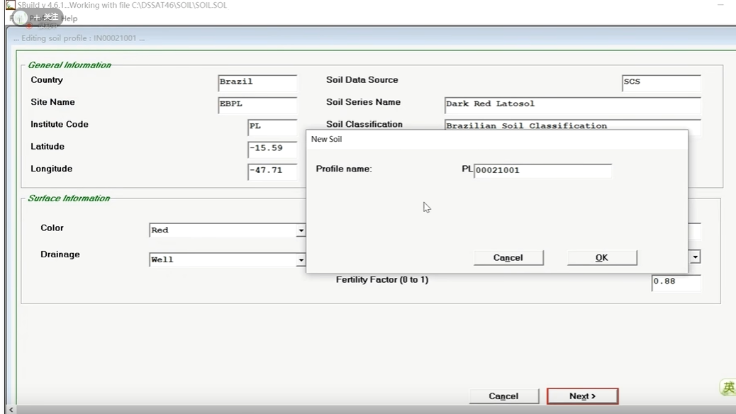
Profile -> close
此时修改内容并未保存到 Soil.SOL文件中,需要再度保存: File -> Save -> exit
作物品种 Genetics(species,ecotype,cultivar) FileC
Planting Information:
The experiment was conducted in 1987 during the dry season with irrigation supplied using sprinklers(灌溉方式 喷灌).
Variety Planted: Cargill 222s(作物品种) (The genetic coefficients for this variety were estimated from a separate experiment; P1 = 390, P2 = 0, P5 = 990, G2 = 770, and G3 = 5, PHINT = 38.90(CUL文件中的参数:P1 从出苗到幼年期结束的度日(基数 8oC) P2 光周期敏感系数(0-1.0) P5 从抽穗到生理成熟的度日(基数 8oC) G2 潜在内核数。G3 潜在果核增长率 mg/(kernel d) PHINT 叶尖萌发所需的度日(植物学间隔)(℃ d)))
Planting Date: 29 April 1987(播种时间)
Planting Depth: 7 cm(播种深度)
Plant Population: 7.0 plants/m2(播种密度)
Row Spacing: 80 cm(行距)
"C:\DSSAT48\Genotype\MZCER048.CUL"
@VAR#  VRNAME.......... EXPNO   ECO#    P1    P2    P5    G2    G3 PHINT
!Coeffient #                             1     2     3     4     5     6
!Calibration                             P     P     P     G     G     N
IB0170 CARGILL 222S         . IB0001 390.0 0.000 990.0 770.0  5.00 38.90
.....................................................................................
! COEFF       DEFINITIONS
! ========    ===========
! VAR#        Identification code or number for a specific cultivar	特定栽培品种的识别码或编号
! VAR-NAME    Name of cultivar	栽培品种的名称
! EXPNO       Number of experiments used to estimate cultivar parameters	用来估计栽培品种参数的实验数

! ECO#        Ecotype code of this cultivar, points to the Ecotype in the
!             ECO file (currently not used).	该栽培品种的生态型代码,指向ECO文件中的生态型(目前未使用)

! P1          Thermal time from seedling emergence to the end of the juvenile
!             phase (expressed in degree days above a base temperature of 8 deg.C)
!             during which the plant is not responsive to changes in
!             photoperiod.	从出苗到幼年期结束的度日(基数 8oC)	从出苗到幼年期结束的热量时间(以高于8摄氏度的基础温度的度日表示),在此期间植物对光周期的变化没有反应。

! P2          Extent to which development (expressed as days) is delayed for
!             each hour increase in photoperiod above the longest photoperiod
!             at which development proceeds at a maximum rate (which is
!             considered to be 12.5 hours).	发育的程度(以天数表示),光照时间每增加一小时,发育就会推迟,在最长的光照时间内,发育速度最快(被认为是12.5小时)

! P5          Thermal time from silking to physiological maturity (expressed
!             in degree days above a base temperature of 8 deg.C).	从抽丝到生理成熟的热量时间(以高于8摄氏度的基准温度的度日表示)

! G2          Maximum possible number of kernels per plant.	 每株植物可能的最大果粒数。
! G3          Kernel filling rate during the linear grain filling stage and
!             under optimum conditions (mg/day).	线性籽粒充填阶段和最佳条件下的籽粒充填率(毫克/天)。

! PHINT       Phylochron interval; the interval in thermal time (degree days)
!             between successive leaf tip appearances. Phylochron间隔;连续出现叶尖的热时间间隔(度日)。 株间的热时间间隔(度日)
实验的管理信息 FileX
记录了要模拟的每个“实验”的模型输入。每个实验可以是真实的实验,有相应的观测到的现场数据,也可以是为模拟定义的假设实验。因此,可以存储许多真实和假设实验的输入以供记录并在不同时间使用。文件标题包含实验代码和名称、处理组合以及实验条件的详细信息(田间特征、土壤分析数据、初始土壤水和无机氮条件、苗床准备和种植几何形状、灌溉和水管理、肥料管理、有机残留物应用、化学品应用、耕作操作、环境改造、收获管理)和模拟控制。实验代码使用与文件命名系统相同的约定来提供有关机构、地点、种植年份、实验编号和作物的信息。例如:UFGA8201MZ,是玉米实验‘01’的代码,由 UF(佛罗里达大学)指定的研究所于 1982 年在 GA 地点(盖恩斯维尔)种植。该文件还可以包含提供实验中使用的数据集的人员的姓名以及有关绘图大小的信息等。
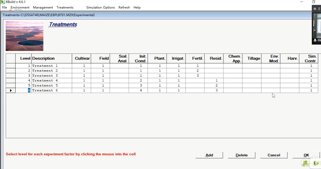
Treatments:
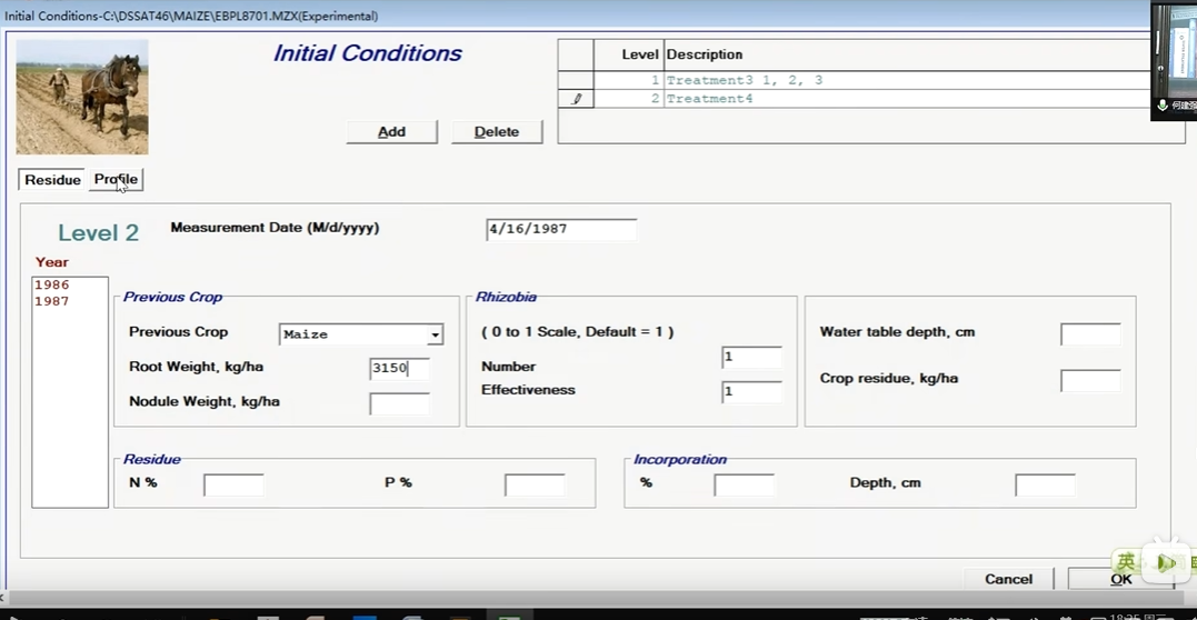
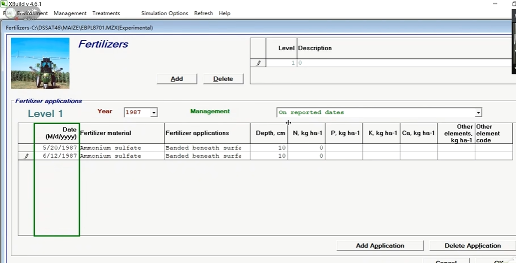
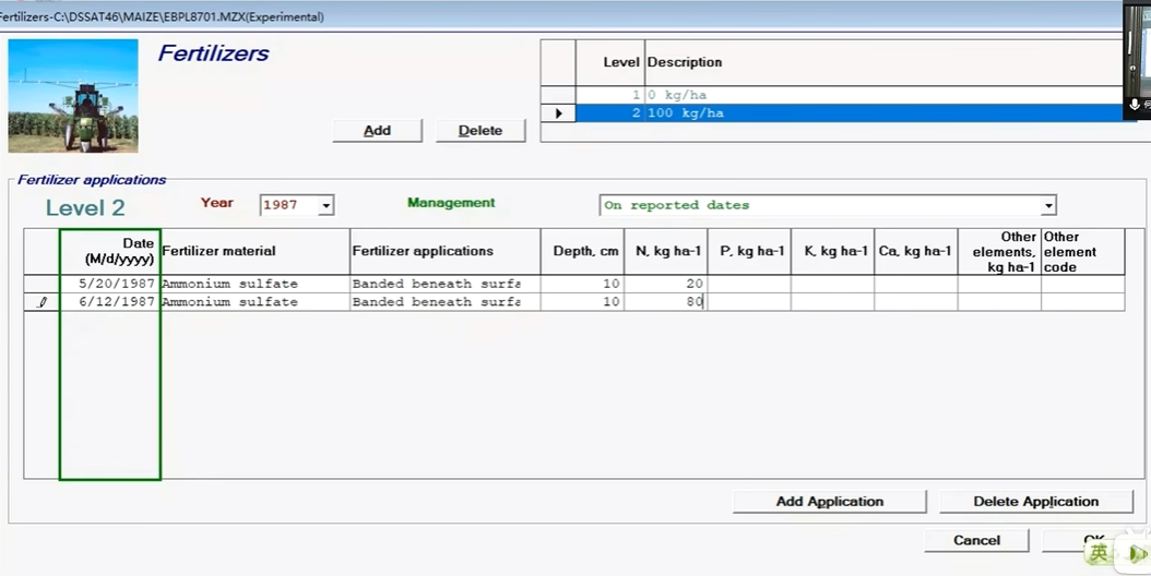
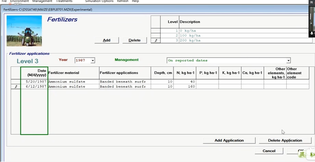
There were six treatments(需要创建6个处理) with varying amounts of N fertilizer or legume green manure applied.
Treatment 1: 0 nitrogen, 0 legume green manure(既不施氮、也不施绿肥)
Treatment 2: l00 kg N/ha applied as ammonium sulfate in two splits: 20 kg applied 21 days after planting and 80 kg applied 44 days after planting, with both banded 10 cm below the surface.(施100公斤/公顷的硫铵分两次:第一次是播后21天。。。)
Treatment 3: 200 kg N/ha applied as ammonium sulfate in two splits: 40 kg applied 21 days after planting and 160 kg applied 44 days after planting, with both banded 10 cm below the surface.
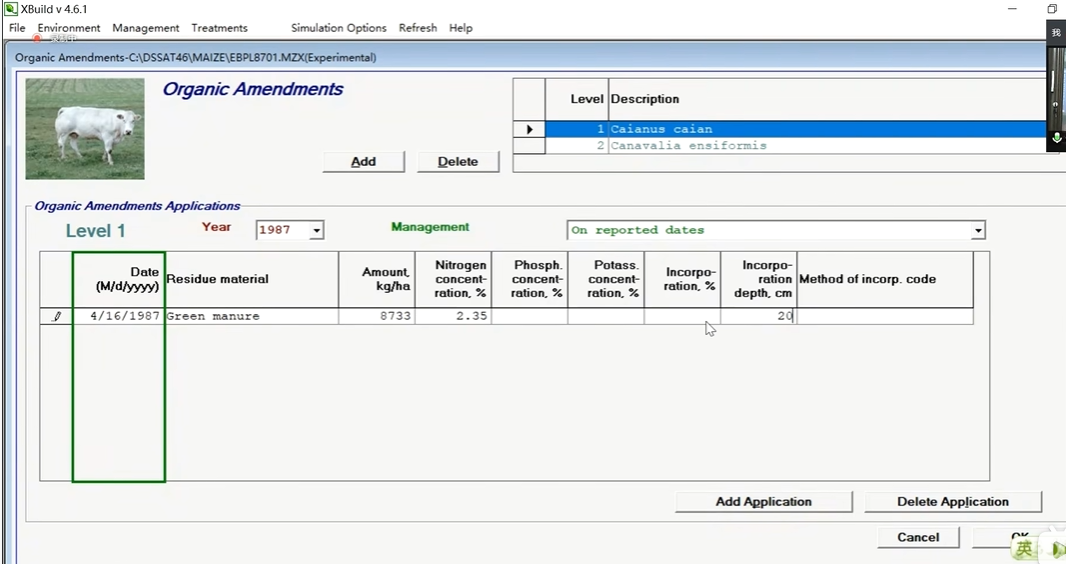
Treatment 4: *Caianus caian* *(木豆)* incorporated to a depth of 20 cm.(混合到地下20cm)
Incorporation date = 16 April 1987(模型模拟应该在4月16号以前)
Dry matter = 8733 kg/ha(干重)
N concentration = 2.35 %(氮素含量)
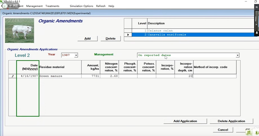
Treatment 5: *Canavalia ensiformis* *(刀豆)*incorporated to 20 cm.
Incorporation date = 16 April 1987
Dry matter = 7731 kg/ha
N concentration = 2.68 %
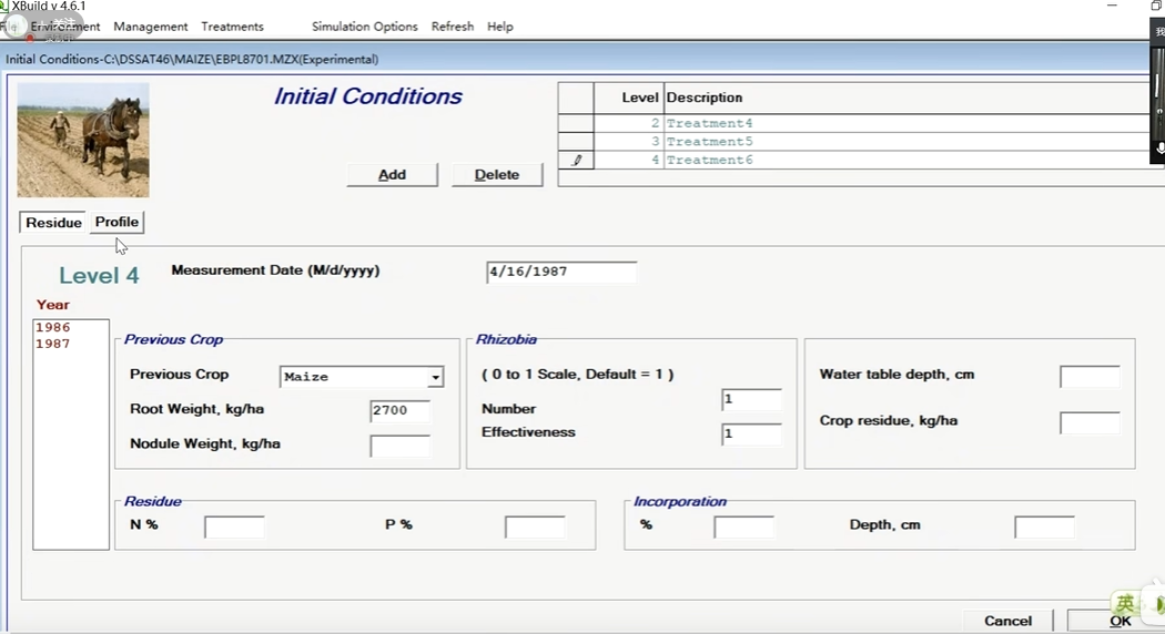
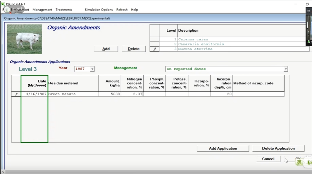
Treatment 6: *Mucuna aterrima* *(油麻藤)* incorporated to 20 cm.
Incorporation date = 16 April 1987
Dry matter = 5638 kg/ha
N concentration = 2.37 %
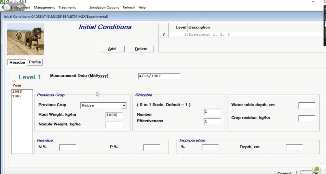
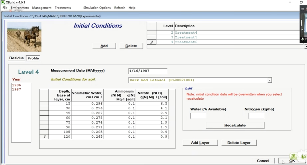
Initial Conditions:
Sampling of the soil for initial conditions was done on 16 April 1987. The amount of root residue for plots with treatments 1, 2 and 3 was 1000 kg/ha, 3150 kg/ha for treatment 4, 3260 kg/ha for treatment 5, and 2700 kg/ha for treatment 6. Soils were sampled for soil water content, ammonium, and nitrate in successive 15 cm increments to a depth of 1.2 m. The results are given below.
Treatments 1, 2, and 3:
土壤剖面
ICBL SH20 SNH4 SNO3 (both SNH4 and SNO3 are in mg/kg)
15 0.296 0.1 3.1
30 0.296 0.1 1.8
45 0.287 0.1 1.9
60 0.278 0.1 1.3
75 0.274 0.1 0.6
90 0.271 0.1 0.6
105 0.265 0.1 0.7
120 0.265 0.1 0.7
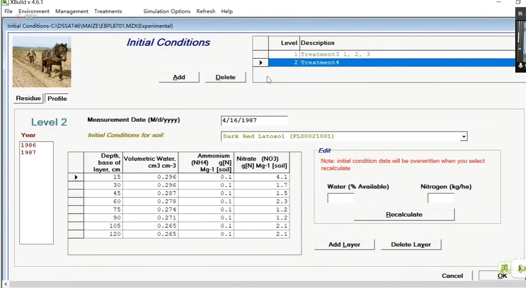
Treatment 4:
ICBL SH20 SNH4 SNO3
15 0.296 0.1 4.1
30 0.296 0.1 1.7
45 0.287 0.1 1.5
60 0.278 0.1 2.3
75 0.274 0.1 1.2
90 0.271 0.1 1.2
105 0.265 0.1 2.1
120 0.265 0.1 2.1
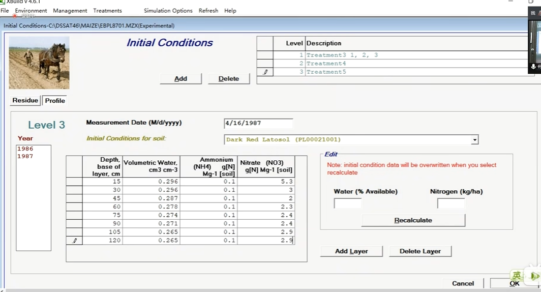
Treatment 5:
ICBL SH20 SNH4 SNO3
15 0.296 0.1 5.3
30 0.296 0.1 3.0
45 0.287 0.1 2.0
60 0.278 0.1 2.3
75 0.274 0.1 2.4
90 0.271 0.1 2.4
105 0.265 0.1 2.9
120 0.265 0.1 2.9
Treatment 6:
ICBL SH20 SNH4 SNO3
15 0.296 0.1 6.5
30 0.296 0.1 4.1
45 0.287 0.1 2.9
60 0.278 0.1 2.1
75 0.274 0.1 1.9
90 0.271 0.1 1.9
105 0.265 0.1 0.9
120 0.265 0.1 0.9
ICBL     Depth, base of layer, cm    深度,层底,厘米
SH2O     Water, cm3 cm-3      土壤含水量
SNH4     Ammonium, KCl, g elemental N Mg-1 soil   铵,氯化钾,克元素N Mg-1土壤
SNO3     Nitrate, KCl, g elemental N Mg-1 soil   硝酸盐,KCl,g元素N Mg-1土壤
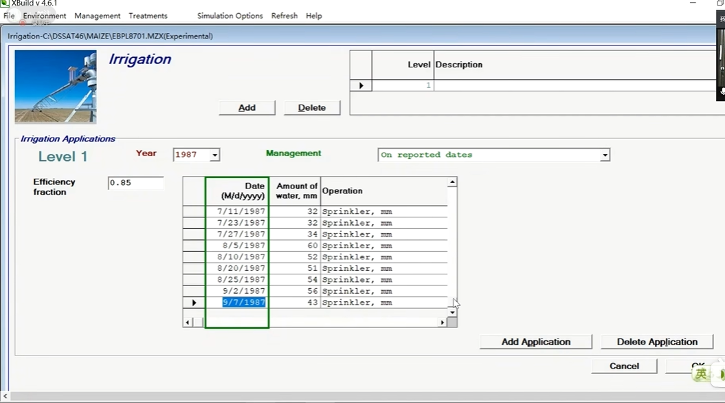
Irrigation: (Irrigation efficiency was estimated at 85%)
@I IDATE IROP IRVAL
1 87132 IR004 32 (5/12/1987)
1 87138 IR004 18 (5/18/1987)
1 87153 IR004 33 (6/02/1987)
1 87162 IR004 20 (6/11/1987)
1 87167 IR004 23 (6/16/1987)
1 87172 IR004 12 (6/21/1987)
1 87178 IR004 20 (6/27/1987)
1 87187 IR004 34 (7/06/1987)
1 87192 IR004 32 (7/11/1987)
1 87204 IR004 32 (7/23/1987)
1 87208 IR004 34 (7/27/1987)
1 87217 IR004 60 (8/05/1987)
1 87222 IR004 52 (8/10/1987)
1 87232 IR004 51 (8/20/1987)
1 87237 IR004 54 (8/25/1987)
1 87245 IR004 56 (9/02/1987)
1 87250 IR004 43 (9/07/1987)
IDATE    Irrigation date, year + day or days from planting 	灌溉日期,年+日或种植后的天数
IROP     Irrigation operation, code     灌溉操作,代码
IRVAL    Irrigation amount, depth of water/watertable, etc., mm    灌溉量、水深/水位等,毫米

*Methods - Irrigation and Water Management (Units for associated data)
@CDE     DESCRIPTION
IR001    Furrow, mm                         沟槽
IR002    Alternating furrows, mm            交替沟渠
IR003    Flood, mm                          漫灌
IR004    Sprinkler, mm                      洒水器
IR005    Drip or trickle, mm                滴灌或涓流
IR006    Flood depth, mm                    漫灌深度
IR007    Water table depth, mm              地下水位深度
IR008    Percolation rate, mm day-1         渗漏率
IR009    Bund height, mm                    盆地高度
IR010    Puddling (for Rice only)           水坑
IR011    Constant flood depth, mm           恒定漫灌深度
操作
Crop Management Data -> New (Management -> Cultivar品种)
Cultivar -> Refresh 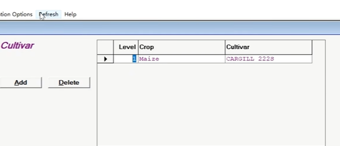
Environment -> Fields:(土壤+气象站)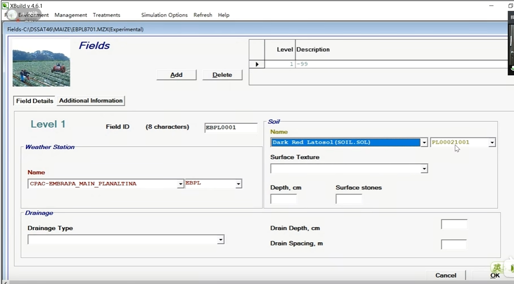
Management -> Planting(播种)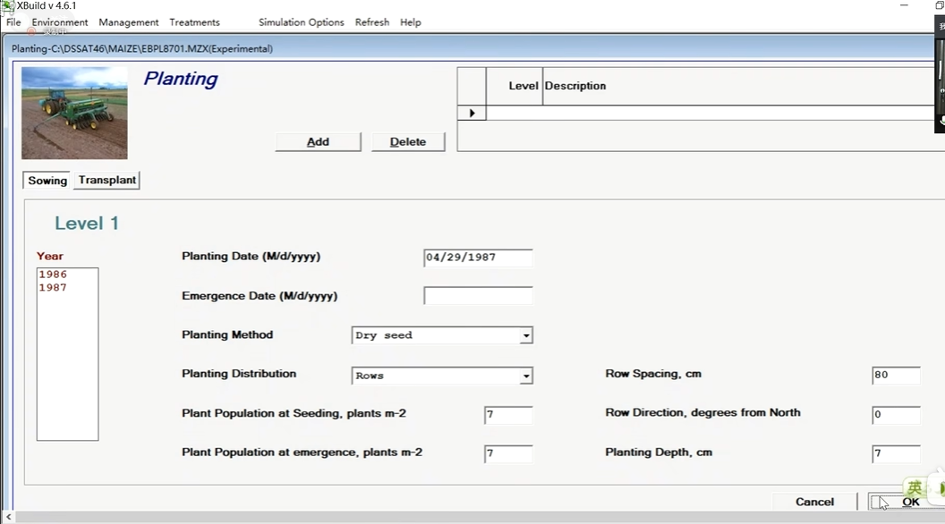
Environment -> Initial Conditions
treatment1,2,3
treatment4
treatment5
treatment6
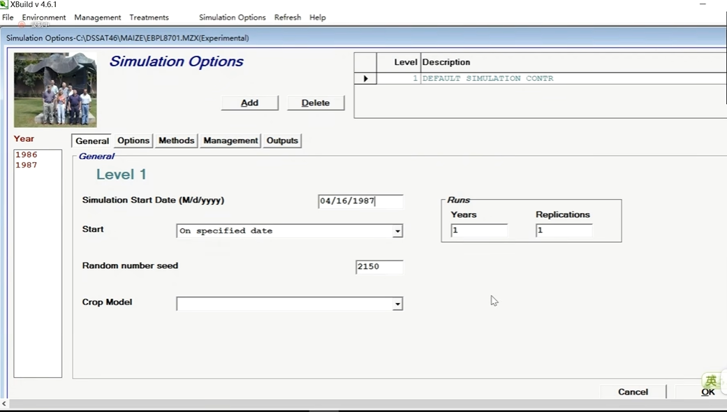
Simulation Options
Management -> Fertilizers(施肥)
Level 1
Level 2
Level 3
Management -> Organic Amendments(有机肥)
Level 1
Level 2
Level 3
Management -> Irrigation(灌溉)
Treatments
观测对比数据/实验数据管理文件
原始数据 -> Experimental Data
A文件 FileA(Average Summary Data)
一个季节里只有一个观测值的观测数据
Observed data for FILEA:

最终产量观测值  成熟时期地上部生物量
@TRNO  HWAM  CWAM  BWAH ADAT MDAT  GN%M  CNAM SNAM  GNAM
     1 3271  9652  6381	207	273	1.37	 69.0 24.3  44.7
     2 5965 15610  9645	207	273	1.42	119.4 34.5  84.9
     3 7213 19224 12011	207	273	1.86	198.4 64.0 134.4
     4 6959 18991 12032	207	273	1.48	149.4 46.2 103.2
     5 6431 18595 12164	207	273	1.80	177.0 61.2 115.8
     6 6276 16225  9949	207	273	1.50	130.2 36.2  94.0
最终产量观测值 成熟时期地上部生物量
TRNO:Treatment number  处理序号
HWAM:Yield at harvest maturity (kg [dm]/ha)  收获成熟期的产量(公斤[分米]/公顷)
CWAM: Tops weight at maturity (kg [dm]/ha)    成熟时的顶部重量(公斤[分米]/公顷)
BWAH :By-product removed during harvest (kg [dm]/ha) 收获期间去除的副产品(公斤[分米]/公顷)
ADAT :Anthesis date (YrDoy)      花期(一年的第多少天)
MDAT : Physiological maturity date (YrDoy) 生理成熟期(YrDoy)
GN%M : Grain N at maturity (%)    成熟时的谷物氮含量(%)
CNAM:  Tops N at maturity (kg/ha)    成熟时的顶部氮(公斤/公顷)
SNAM : Stem N at maturity (kg/ha)   成熟期的茎氮(公斤/公顷)
GNAM: Grain N at maturity (kg/ha)  成熟期的谷物氮(公斤/公顷)
T文件 FileT(Average Time Course Data)
一个季节里有多个观测值
Observed data for FILET:

Growth components:(生长有关的观测值)(每个处理观测8次)

      @TRNO	DATE 	 CWAD	SWAD	GWAD	LWAD	CNAD
1	87150 	  180	0	0	0	6.8
1	87163	   475	0	0	0	14.0
1	87178	  2321	0	0	0	45.2
1	87192	  3525	0	0	0	41.2
.......
Soil moisture measurements:(土壤水分含量的观测值)(每个处理观测4次)

	@TRNO		DATE	W115	W215	W315	W415
			            (SW2D)       (SW3D) (SW4D)  (SW5D)
1		87131	0.27	0.29	0.28	-99
1		87204	0.23	0.25	0.24	0.23
1		87244	0.25	0.26	0.25	0.25
1		87281	0.25	0.28	0.27	0.26
2		87131	0.27	0.29	0.28	-99
2		87204	0.23	0.25	0.24	0.23
.........
Soil inorganic N components:(土壤中有机氮的含量)(每个处理观测4次)

@TRNO		DATE	N115	N215	N315	N415	N515	N615	N715	N815
                                 (NI2D)  (NI3D)   (NI4D)  (NI5D)   (NI6D)  (NI7D)   (NI8D)   (NI9D)
	1	87131	7.6	6.0	2.0	-99	-99	-99	-99	-99
	1	87204	1.2	0.1	0.1	0.3	0.1	0.1	0.1	0.1
	1	87244	0.5	0.5	2.4	2.4	0.9	0.9	1.4	1.4
	1	87281	2.3	1.4	0.6	1.8	0.8	0.8	0.6	0.6
	2	87131	7.6	6.0	2.0	-99	-99	-99	-99	-99
.........
Growth components:(生长有关的观测值)
CWAD:	 Tops weight (kg [dm]/ha)   顶端重量(公斤[分米]/公顷)
SWAD:	 Stem weight (kg [dm]/ha)     茎重(公斤[分米]/公顷)
GWAD:	 Grain weight (kg [dm]/ha)    粒重(公斤[分米]/公顷)
LWAD:	 Leaf weight (kg [dm]/ha)   叶重(公斤[分米]/公顷)
CNAD:    Tops N (kg/ha)      顶部的氮(公斤/公顷)
Soil moisture measurements:(土壤水分含量的观测值)
W115(SW2D)	不同土层   Soil water, soil layer 2 (cm3/cm3)  土壤水,土壤层2(cm3/cm3)。
W215 (SW3D)
W315(SW4D)
W415(SW5D)
Soil inorganic N components:(土壤中无机氮的含量)
N115 (NI2D)	无机氮第二层
N215 (NI3D)	 NO3, soil layer 3 (ug [N]/g [soil])     NO3,土壤层3(微克[N]/克[土壤])。
N315 (NI4D)
N415 (NI5D)
N515 (NI6D)
N615 (NI7D)
N715 (NI8D)
N815 (NI9D)
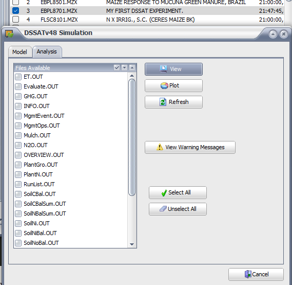
输出数据
Daily output files
OUTPUT.CDE
@NAME... CDE ... Description........
ET.OUT
EB Daily soil-plant-atmosphere output file 土壤-植物-大气的每日输出文件
PlantGro.OUT
PG Daily plant growth output file 每日植物生长输出文件
PlantC.OUT
PC Daily plant carbon output file 每日植物碳输出文件
PlantN.OUT
PN Daily plant nitrogen output file 每日植物氮素输出文件
PlantP.OUT
PP Daily plant phosphorus output 每日植物磷产量
SoilDyn.OUT
Daily soil dynamics output file (temp) 每日土壤动力学输出文件(临时)
SoilNi.OUT
SN Daily inorganic soil N output file 每日无机土壤氮输出文件
SoilOrg.OUT
SC Daily soil carbon output file 每日土壤碳输出文件
SoilPi.OUT
SP Daily inorganic soil phosphorus output file 每日无机土壤磷输出文件
SoilKi.OUT
SK Daily inorganic soil potassium output file 每日无机土壤钾输出文件
SoilTemp.OUT
TS Daily soil temperature output file 每日土壤温度输出文件
SoilWat.OUT
SW Daily soil water output file 每日土壤水分输出文件
Weather.OUT
WE Daily weather output file 每日气象输出文件
N2O.OUT
NO Soil N2O and N2 daily emissions output 土壤N2O和N2的日排放量输出
GHG.OUT
Greenhouse gas emissions report 温室气体排放报告
Mulch.OUT
Daily surface mulch output file 每日表面覆盖物的输出文件
Seasonal Summary output files
Summary.OUT
SU Seasonal summary output file 季节性总结输出文件
Evaluate.OUT
EV Evaluation output file (simulated vs. measured) 评价输出文件(模拟与测量的对比)
Overview.OUT
OV Seasonal overview output file 季节性概述输出文件
SoilWatBal.OUT
Seasonal soil water balance 季节性土壤水分平衡
SoilNiBal.OUT
Seasonal inorganic soil N balance 季节性的土壤无机氮平衡
SoilPiBal.OUT
Seasonal inorganic soil P balance 季节性无机土壤P平衡
SoilKiBal.OUT
Seasonal inorganic soil K balance 季节性无机土壤K平衡
SoilNoBal.OUT
Seasonal organic soil N balance 季节性的土壤有机氮平衡
SoilPoBal.OUT
Seasonal organic soil P balance 季节性有机土壤P平衡
PlantCBal.OUT
Not currently operational 目前尚未投入使用
PlantNBal.OUT
Plant nitrogen balance 植物的氮平衡
PlantPBal.OUT
Plant phosphorus balance 植物磷平衡
MgmtEvent.OUT
ME Management event output file 管理事件输出文件
MgmtOpsSum.OUT
OP Operations summary output file 业务总结输出文件
Information files:
ERROR.OUT Error messages 错误信息
INFO.OUT Information output file 信息输出文件
WARNING.OUT Warning messages 警告信息
WORK.OUT CSCER, CSP information output file CSCER,CSP信息输出文件
CSCER wheat/barley – Tony to summarize improvements

 浙公网安备 33010602011771号