
[原][OE][官方例子]osgearth_features OE地球添加shp文件(特征标识)
官方示例代码
/* -*-c++-*- */
/* osgEarth - Dynamic map generation toolkit for OpenSceneGraph
* Copyright 2016 Pelican Mapping
* http://osgearth.org
*
* osgEarth is free software; you can redistribute it and/or modify
* it under the terms of the GNU Lesser General Public License as published by
* the Free Software Foundation; either version 2 of the License, or
* (at your option) any later version.
*
* THE SOFTWARE IS PROVIDED "AS IS", WITHOUT WARRANTY OF ANY KIND, EXPRESS OR
* IMPLIED, INCLUDING BUT NOT LIMITED TO THE WARRANTIES OF MERCHANTABILITY,
* FITNESS FOR A PARTICULAR PURPOSE AND NONINFRINGEMENT. IN NO EVENT SHALL THE
* AUTHORS OR COPYRIGHT HOLDERS BE LIABLE FOR ANY CLAIM, DAMAGES OR OTHER
* LIABILITY, WHETHER IN AN ACTION OF CONTRACT, TORT OR OTHERWISE, ARISING
* FROM, OUT OF OR IN CONNECTION WITH THE SOFTWARE OR THE USE OR OTHER DEALINGS
* IN THE SOFTWARE.
*
* You should have received a copy of the GNU Lesser General Public License
* along with this program.  If not, see <http://www.gnu.org/licenses/>
*/

#include <osg/Notify>
#include <osgGA/StateSetManipulator>
#include <osgViewer/Viewer>
#include <osgViewer/ViewerEventHandlers>
#include <osgEarth/Map>
#include <osgEarth/MapNode>
#include <osgEarth/ImageLayer>
#include <osgEarth/ModelLayer>
#include <osgEarthUtil/ExampleResources>
#include <osgEarthUtil/EarthManipulator>
#include <osgEarthUtil/AutoClipPlaneHandler>

#include <osgEarthSymbology/Style>
#include <osgEarthFeatures/FeatureModelLayer>
#include <osgEarthFeatures/ConvertTypeFilter>

#include <osgEarthDrivers/engine_rex/RexTerrainEngineOptions>
#include <osgEarthDrivers/gdal/GDALOptions>
#include <osgEarthDrivers/feature_ogr/OGRFeatureOptions>
#include <osgEarthDrivers/agglite/AGGLiteOptions>
#include <osgEarthDrivers/model_feature_geom/FeatureGeomModelOptions>

#include <osgDB/WriteFile>

using namespace osgEarth;
using namespace osgEarth::Features;
using namespace osgEarth::Drivers;
using namespace osgEarth::Symbology;
using namespace osgEarth::Util;

int usage(const std::string& app)
{
    OE_NOTICE "\n" << app << "\n"
        << "    --rasterize           : draw features as rasterized image tiles \n"
        << "    --overlay             : draw features as projection texture \n"
        << "    --mem                 : load features from memory \n"
        << "    --labels              : add feature labels \n"
        << "\n"
        << MapNodeHelper().usage();

    return -1;
}

//
// NOTE: run this sample from the repo/tests directory.
//
int main(int argc, char** argv)
{
    osg::ArgumentParser arguments(&argc, argv);

    if (arguments.read("--help"))
        return usage(argv[0]);

    bool useRaster = arguments.read("--rasterize");
    bool useOverlay = arguments.read("--overlay");
    bool useMem = arguments.read("--mem");
    bool useLabels = arguments.read("--labels");


    osgViewer::Viewer viewer(arguments);

    // Start by creating the map:
    Map* map = new Map();

    // Start with a basemap imagery layer; we'll be using the GDAL driver
    // to load a local GeoTIFF file:
    GDALOptions basemap;
    basemap.url() = "E:/temp/OE/data/world.tif";
    map->addLayer(new ImageLayer(ImageLayerOptions("basemap", basemap)));

    // Next we add a feature layer.
    OGRFeatureOptions ogrData;
    if (!useMem)
    {
        // Configures the feature driver to load the vectors from a shapefile:
        ogrData.url() = "E:/temp/OE/data/world.shp";
    }
    else
    {
        // the --mem options tells us to just make an in-memory geometry:
        Ring* line = new Ring();
        line->push_back(osg::Vec3d(-60, 20, 0));
        line->push_back(osg::Vec3d(-120, 20, 0));
        line->push_back(osg::Vec3d(-120, 60, 0));
        line->push_back(osg::Vec3d(-60, 60, 0));
        ogrData.geometry() = line;
    }

    // Make a feature source layer and add it to the Map:
    FeatureSourceLayerOptions ogrLayer;
    ogrLayer.name() = "vector-data";
    ogrLayer.featureSource() = ogrData;
    map->addLayer(new FeatureSourceLayer(ogrLayer));

    // Define a style for the feature data. Since we are going to render the
    // vectors as lines, configure the line symbolizer:
    Style style;

    LineSymbol* ls = style.getOrCreateSymbol<LineSymbol>();
    ls->stroke()->color() = Color::Yellow;
    ls->stroke()->width() = 2.0f;

    // That's it, the map is ready; now create a MapNode to render the Map:
    osgEarth::Drivers::RexTerrainEngine::RexTerrainEngineOptions rex;

    MapNodeOptions mapNodeOptions;
    mapNodeOptions.enableLighting() = false;
    mapNodeOptions.setTerrainOptions(rex);
    MapNode* mapNode = new MapNode(map, mapNodeOptions);

    osg::Group* root = new osg::Group();
    root->addChild(mapNode);
    viewer.setSceneData(root);
    viewer.setCameraManipulator(new EarthManipulator());

    // Process cmdline args
    MapNodeHelper().parse(mapNode, arguments, &viewer, root, new LabelControl("Features Demo"));

    if (useRaster)
    {
        AGGLiteOptions rasterOptions;
        rasterOptions.featureOptions() = ogrData;
        rasterOptions.styles() = new StyleSheet();
        rasterOptions.styles()->addStyle(style);
        map->addLayer(new ImageLayer("My Features", rasterOptions));
    }
    else //if (useGeom || useOverlay)
    {
        FeatureModelLayerOptions fml;
        fml.name() = "My Features";
        fml.featureSourceLayer() = "vector-data";
        fml.styles() = new StyleSheet();
        fml.styles()->addStyle(style);
        fml.enableLighting() = false;

        map->addLayer(new FeatureModelLayer(fml));
    }

    if (useLabels)
    {
        // set up symbology for drawing labels. We're pulling the label
        // text from the name attribute, and its draw priority from the
        // population attribute.
        Style labelStyle;

        TextSymbol* text = labelStyle.getOrCreateSymbol<TextSymbol>();
        text->content() = StringExpression("[cntry_name]");
        text->priority() = NumericExpression("[pop_cntry]");
        text->size() = 16.0f;
        text->alignment() = TextSymbol::ALIGN_CENTER_CENTER;
        text->fill()->color() = Color::White;
        text->halo()->color() = Color::DarkGray;

        // and configure a model layer:
        FeatureModelLayerOptions fml;
        fml.name() = "Labels";
        fml.featureSourceLayer() = "vector-data";
        //fml.featureSource() = featureOptions;
        fml.styles() = new StyleSheet();
        fml.styles()->addStyle(labelStyle);

        map->addLayer(new FeatureModelLayer(fml));
    }


    // add some stock OSG handlers:
    viewer.addEventHandler(new osgViewer::StatsHandler());
    viewer.addEventHandler(new osgViewer::WindowSizeHandler());
    viewer.addEventHandler(new osgGA::StateSetManipulator(viewer.getCamera()->getOrCreateStateSet()));


    osg::ref_ptr<osg::GraphicsContext::Traits> traits = new osg::GraphicsContext::Traits;
    traits->x = 200;
    traits->y = 200;
    traits->width = 800;
    traits->height = 680;
    traits->windowDecoration = true;
    traits->doubleBuffer = true;
    traits->sharedContext = 0;

    osg::ref_ptr<osg::GraphicsContext> gc = osg::GraphicsContext::createGraphicsContext(traits.get());

    osg::ref_ptr<osg::Camera> camera = new osg::Camera;
    camera->setGraphicsContext(gc.get());
    camera->setViewport(new osg::Viewport(0, 0, traits->width, traits->height));
    GLenum buffer = traits->doubleBuffer ? GL_BACK : GL_FRONT;
    camera->setDrawBuffer(buffer);
    camera->setReadBuffer(buffer);
    viewer.addSlave(camera);

    return viewer.run();
}
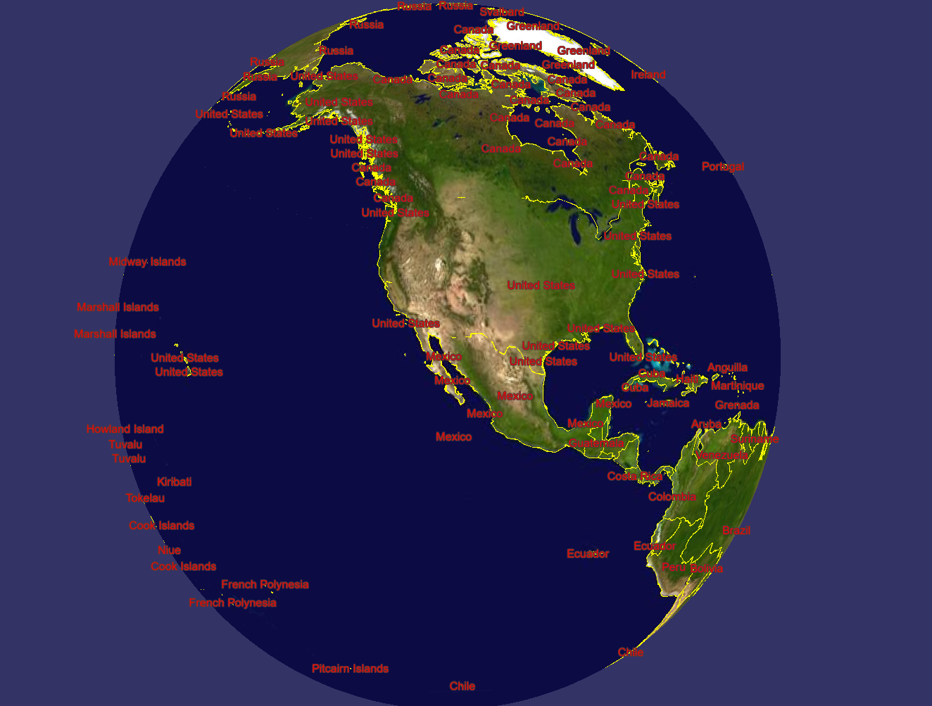
开启"--labels" 标注的图元信息,这些是读取shp中的字段加载的!
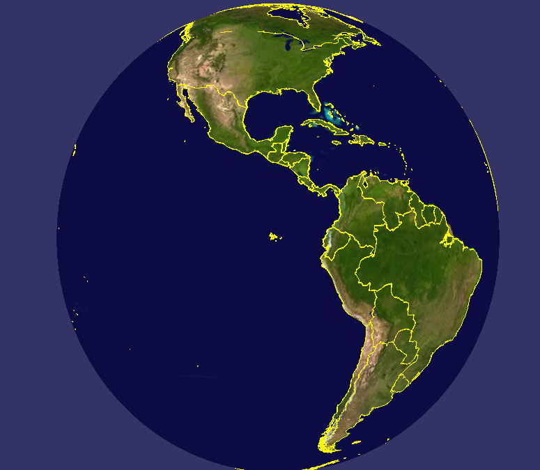
        Ring* line = new Ring();
        line->push_back(osg::Vec3d(-60, 20, 0));
        line->push_back(osg::Vec3d(-120, 20, 0));
        line->push_back(osg::Vec3d(-120, 60, 0));
        line->push_back(osg::Vec3d(-60, 60, 0));
        ogrData.geometry() = line;
开启"--mem"代码绘制
开启"--mem"代码绘制
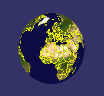
开启栅格化"--rasterize"
